Roberta Gilchrist and Hella Eckardt nominated in Current Archaeology Awards!

RobertaGilchrist_3283-e (1)Professor Roberta Gilchrist has been nominated for ‘Archaeologist of the Year’ in the 8th Annual Current Archaeology Awards.

Roberta’s nomination recognises her work as a pioneer of social approaches to medieval archaeology, a champion of equal opportunities, and her work with Norwich Cathedral and Glastonbury Abbey. The full nomination reads:

“Roberta Gilchrist is Professor of Archaeology at the University of Reading.  She has pioneered social approaches to medieval archaeology, opening up new questions on gender and age and publishing important studies on medieval nunneries, hospitals, castles, and burials. Roberta has been a champion for equal opportunities, promoting women in archaeology and leading initiatives to integrate disability into the teaching of archaeological fieldwork. She was archaeologist to Norwich Cathedral and published a major study of Norwich Cathedral Close. Her monograph on the excavations at Glastonbury Abbey (1904–79) has just been published, making the results of 36 seasons of antiquarian excavations available for the first time. She is currently working with the Abbey on digital reconstructions and educational resources to make this work accessible to visitors.”


Objects-and-Identities_opt-195x300

Dr Hella Eckardt’s book ‘Objects and Identities: Roman Britain and the North-Western Provinces’ has been nominated for ‘Book of the Year’!

“Every object, however humble, has a tale to tell, and in this fascinating book carefully-chosen case studies tease out the ways that artefacts reflect their owners’ values and aspirations. From utilitarian kit to imported luxury goods, the items examined paint a vivid picture of regional variation, and approaches to consumption and display.”


You can cast your vote for both nominees here.

Silchester – Summer Excavations Updates

This summer, the Silchester team(s) were back in the field again for both the Insula III project and the Environs Iron Age project. Amanda Clarke and Dr Cathie Barnett give their updates below…

Never say Never Again: further excavations at Silchester Roman Town

By Amanda Clarke

Professor Michael Fulford, CBE and Archaeologist of the Year, is as near as our profession will get to having Royal Navy Commander James Bond on its books. And, in true 007 style, and with reference to the 1983 Bond film of that name, we have learnt that The Commander will Never say Never Again.

Mike and I had left a hole in the ground (and in our hearts…..) at Insula IX in August 2014, and had walked away, olive trees in hand (our farewell presents from the participants), never thinking we would be back.

Groundhog Day

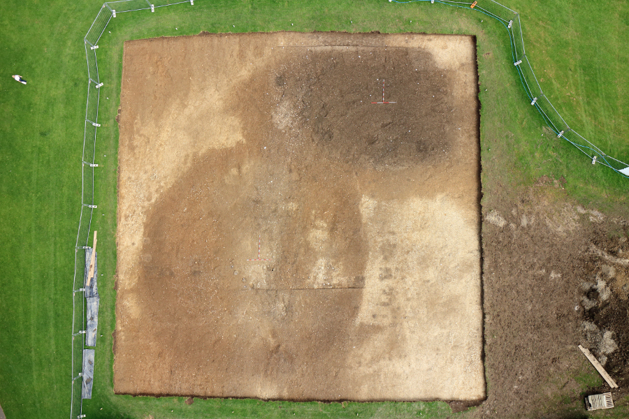
Now here I was, returning to Silchester in August of 2015, to set up and run a 4-week project to excavate a 15m by 20m trench in the north-east corner of Insula 111 in the heart of the Roman Town.
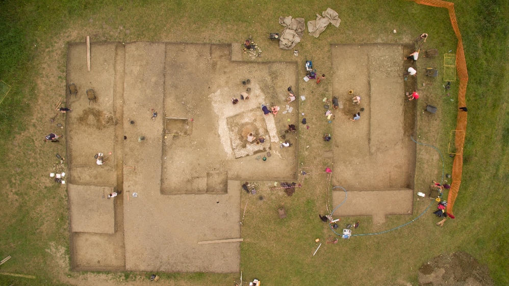
The Insula III team

The Insula III team

What could possibly lure us back? Insula III has been pivotal to our research excavations at Silchester for several years now. In 2013 and 2014 we opened an area 30m by 30m in the south-east of Insula III with the aim of re-excavating the Victorian trenches (dug in 1891) to reveal the structure the Victorians had thought – excitingly – to be a bath house. This methodology – of walking and digging in Victorian footsteps – proved to be an extremely successful one and allowed us, with the minimum of new excavation, to understand further the Victorian campaigns and methods of excavation, as well as determining at least 3 phases of Roman and post-Roman occupation of this part of the insula.

Palaces and Promises

We returned in 2015 to the north-east corner of Insula III as we hoped, by implementing our established methodology of Victorian shadowing, to uncover further evidence for the early Roman palatial structure (misidentified by the Victorians as a ‘bath house’) we had exposed in 2013 and 2014. This would lead our research in a new and exciting direction, promising an early Roman template of town planning, possibly under the auspices of the Emperor Nero.

Victorian mayhem

The first week of excavation in 2015 revealed several things fairly rapidly to our team of volunteers, Silchester ‘old-hands’ and aspiring 1st, 2nd and 3rd year students. For a start, the Victorians had been fairly brutal in their excavation techniques and had employed a methodology which resembled the path of a modern-day bulldozer. However, silver linings and all that, as the excavators of 1893 had avoided and outlined the extent of the spoil heap of the Basilica-Forum excavators of the 1860’s, who had placed an enormous and intimidating mound of soil from their forum excavations all along the western edge of the North-South Roman street, extending into the north-east area of Insula III. This meant that preserved intact beneath the outline of this spoil heap were undisturbed late Roman and potentially post Roman deposits – something of a holy grail for Silchester archaeologists who have been long intent on illuminating the final years of the Roman town.

webbedfeet&waterproofs

Sadly however there was no evidence for the continuation of the large palatial building located in the south-east of the insula – instead a packed stratigraphy visible in the sides of the Victorian trenches promised a different story.

Our second week on site proved an enormous challenge on many fronts; we had to re-employ our JCB to remove the huge depth of Victorian backfill we were confronted with, as we recognised that this Victorian-sorted soil would only enhance our muscles, and not our minds. As well as this, it rained – very hard. For days on end.

A Case of Mistaken Identity

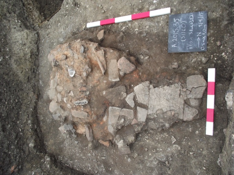
By the start of the third week, the Victorian interventions had been emptied, mapped and plotted, and we now had time to look at what they had left behind. The Victorian plan was a red herring – nothing recorded on it was as we found it – but we did gain further insight into the Victorian psyche. For example, a feature recorded on their plan as ‘HYP’ (hypocaust) and left in situ, turned out to be an early Roman hearth, pedestalled and separated from its context – but still intact, beautiful, and able to be sampled and studied.

The early Roman Hearth

The early Roman Hearth

Targeted excavation

The Victorian excavators had not reached the natural ground surface but had instead stopped at an extensive spread of gravel of early Roman date. So, our methodology was to extend downwards from some areas of the Victorian intervention to see if we could stratigraphically uncover the earliest occupation on this part of the insula. This we did, revealing a number of Iron Age features at the base of the sequence.

It’s all in the section

The strategy for the fourth week on site was simple: to record and sample the sides of the Victorian trenches – which contained the story of Insula III from earliest to latest – and to begin stratigraphic excavation of the late Roman tabernae, or small shops which fronted onto the north-south and east-west streets, and lay beneath the dark soils. The remains of these buildings had eluded the Victorians but we were able to recognise them as flint and gravel founded buildings with clay floors, and backyards consisting of gravelled areas delineated by post pads.


Final Thoughts

After 4 weeks on site we ended with a very successful Open Day and were able to present our many visitors with a coherent story about the development of the north-east corner of Insula III. Our work has revealed a complexity of occupation on this central insula, and has provided a tantalising glimpse of the richness of the archaeological record here. Now follows a winter of post excavation to establish the chronology of the area, and the chance to assess the many finds left behind by the Victorians – which included more than 66 coins. See you next year!


Pond Farm

By Dr Catherine Barnett

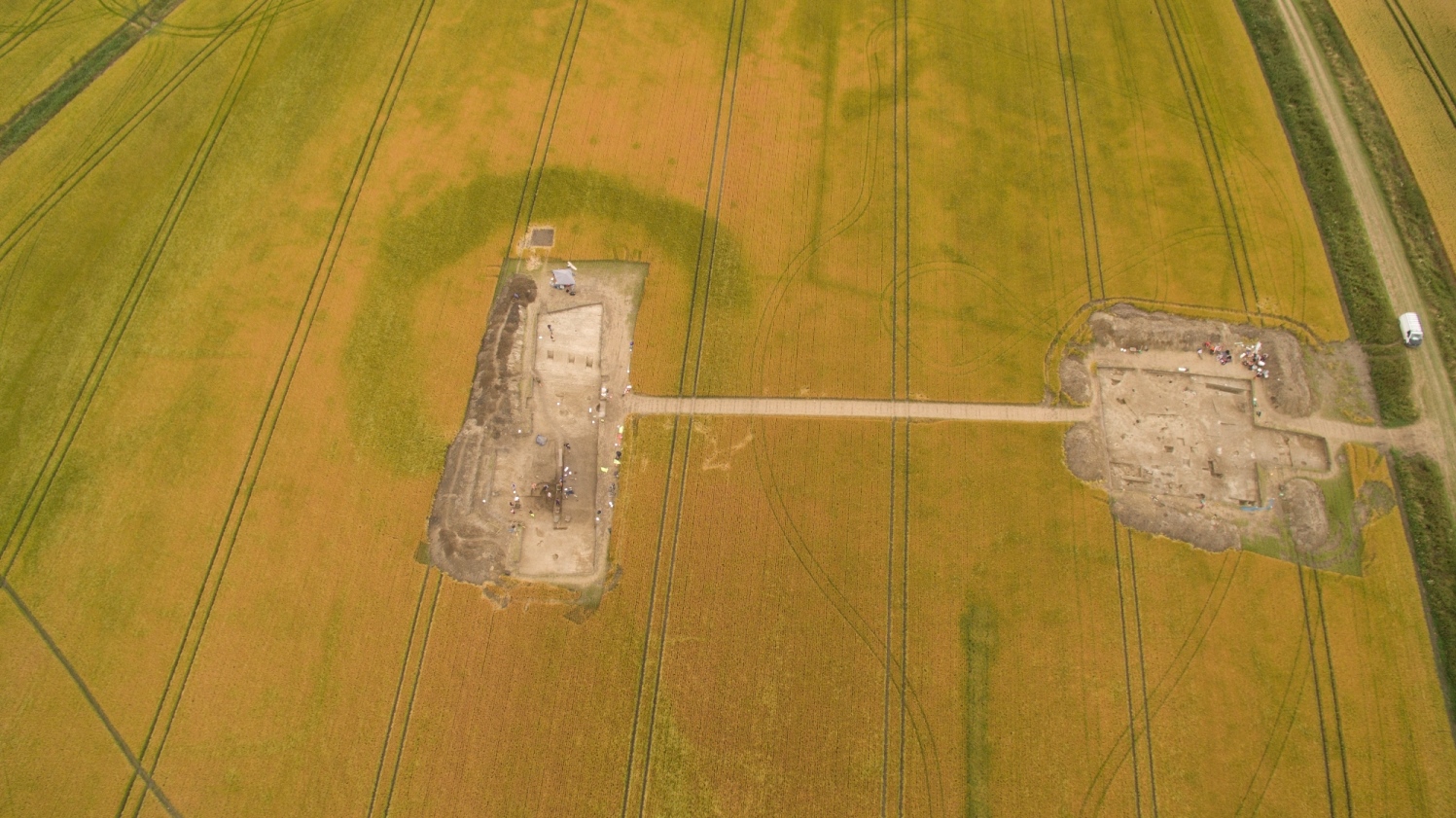
A team of 15 hardy professional, student and volunteer archaeologists, led by project officer Nick Pankhurst, ignored the August-September monsoon season to tackle the site of Pond Farm. The site was suspected to be an Iron Age univallate hillfort and had been chosen as the first in a series of sites to investigate under the new Silchester Environs project led by Prof Michael Fulford.

Four 20x20m trenches were opened up across the site, positioned according to the results of geophysical and coring surveys undertaken earlier this year. Key aims were to date the site and to gauge whether it had a chronological relationship with the nearby Iron Age oppidum that underlies Silchester Roman Town. We also wanted to find out what the site was used for and for how long. Artefacts proved sparse but appeared in just the right places, including a piece of Late Iron Age pedestal beaker recovered from a palisade trench at the end of the defensive encircling bank. The lack of internal structures yet evidence of several phases of earthwork and ditch recutting leads us to suspect that this was not a permanently settled site but one periodically visited over a long time, perhaps as part of a stock management system, with the huge defensive earthworks there to protect valuable livestock.

Much of our understanding  will however come from the post-excavation analysis and radiocarbon dating of samples collected during the dig. These are currently being processed, and we’ll let you know what we find in a future post.

For further information on the Environs project please see the Silchester website or email Dr Catherine Barnett at c.m.barnett@reading.ac.uk.  


You can also follow Silchester on Facebook and Twitter for the latest updates!

Uncovering the secrets of ‘the Blob’: a spectacular finale to the Lyminge excavations

By Dr Gabor Thomas

1.View over 2014 excavations with the Blob in the foreground trench and the Coach and Horses pub in the background overlooked by Lyminge church

View over 2014 excavations with the Blob in the foreground trench and the Coach and Horses pub in the background overlooked by Lyminge church

In September of this year the curtain closed on one of the department’s flagship fieldwork projects: a seven-year programme of excavation targeting an Anglo-Saxon settlement preserved under the village of Lyminge in south-east Kent.  Fieldwork projects of this scale and complexity nearly always run out of time and Lyminge is no exception.  2014 was supposed to be the final season of a three-year campaign funded by the Arts and Humanities Research Council designed to investigate a large open space in the middle of the village called Tayne Field.  In the event, the new discoveries made that year were so unprecedented that it was impossible to examine the evidence satisfactorily in the six weeks available.  With the realisation that more work was needed, plans for a return season soon began to be hatched; by the following spring funds for a pared-down excavation had been secured from several sources, including a generous donation from a member of the Sutton Hoo Society who visited us in 2014.  Game on!

The cause of our extended season was first identified in a geophysical survey completed by Dave Thornley in 2012.

Aerial view of the Blob and adjacent ring-ditch after initial cleaning in 2014.

Aerial view of the Blob and adjacent ring-ditch after initial cleaning in 2014.

The ‘Blob’, as it soon became known amongst the excavation team, appeared as a large (18m by 12m) ovoid anomaly straddling the ring-ditch of a Bronze Age barrow.  Both features lay at the northern margins of a dense array of Anglo-Saxon settlement remains which had formed the principal target of excavations in 2012-13.  When uncovered for the first time in 2014, the feature stood out like a sore thumb: an expanse of charcoal-rich sediment crammed with animal bone and artefacts immediately recognisable as Anglo-Saxon.  Gold dust – we were staring at a huge, and as we would later find out, very deep, Anglo-Saxon midden!  Because all of the material removed from the Blob was dry sieved, progress was slow going and it soon became apparent that we could only investigate a small sample in the time available.  We therefore limited our window to a pair of 1m-wide perpendicular transects positioned across the maximum girth of the Blob.  Each of these slices produced a vivid layer-cake of dumped deposits punctuated by burnt horizons and, in one particular locale, an in situ hearth.  By the beginning of the final week both transects had been excavated to a depth of 1.80m, but with no sign of a bottom.  Then, in the final few days, we broke through the earliest of the Anglo-Saxon dumps to reveal a horizontal layer of flint nodules.  Time was up and we were left to ponder the hard-won evidence: what was the origin of the large crater used as a dumping ground by the Anglo-Saxons? And what was the function and age of the enigmatic flint layer?

These questions were foremost as a skeleton team reassembled to take on the Blob with renewed vigour in 2015.  Our strategy involved re-opening 2014’s transects to investigate the lower levels of the Blob (where possible) with further hand excavation, leaving the deepest portions for coring.  In addition, we planned to excavate a new 2m-wide transect across the unexplored northern sector of the Blob with the aim of exposing the full extent of the layer of flint nodules.  So what did we find?  The upper horizons of the midden sampled by the new transect proved to be as productive in Anglo-Saxon cultural material as in 2014, yielding a further 200 sherds of vessel glass, an array of brooches and other diagnostic metalwork and prodigious volumes of pottery and animal bone.  The new transect also revealed the full extent of the flint layer demonstrating that it formed a sloping ramp extending from the northern rim of the Blob down into its murky depths where it was first exposed in 2014 at depth of nearly 2m. Further excavation and coring in the previous season’s transects produced equally rewarding results.  We now know that the original cut of the Blob has a strongly asymmetrical profile and that its lower stratigraphy comprises clay-rich sediments deposited during later prehistory under natural processes.

Kevin Williams from QUEST assisted by Simon Maslin get stuck into some coring.

Kevin Williams from QUEST assisted by Simon Maslin get stuck into some coring.

So what does all this evidence add up to?  I would be lying if I said we had a definitive answer so soon after the excavation, but a compelling story is starting to emerge.  It goes something like this.  The Blob started life as a natural feature – a solution hollow, or to give it its correct label, a doline, produced by the erosion of soluble bedrock.  This particular example may have opened up early in prehistory and, as a significant landscape feature, could have acted as a focus for the construction for the adjacent Bronze Age barrow (such associations have been documented in other prehistoric chalklands, including the Dorset ridgeway).  When an Anglo-Saxon settlement was established in Lyminge in the 5th century A.D., the doline was reappropriated, commencing with the construction of the flint ramp to provide access into the deepest portion of the feature.  This may have been to facilitate the extraction of clay for the making of pottery and daub for buildings and furnaces, but alternative, potentially ritualistic, uses cannot be discounted.  Subsequently, as the Anglo-Saxon population expanded and economic activity intensified, midden material collected from various domestic and industrial contexts was systematically dumped into the cavity.  This process of infilling extended into the second half of the 6th century, but was punctuated by episodes of stabilisation when the hollow was used for industrial processes such as iron smelting reflected archaeologically in hearths and associated dumps of slag and furnace lining.

Although compelling, there are parts of this story which will remain speculative until the evidence has been carefully evaluated by professional geologists.  However, if the hypothesised sequence turns out to be correct in its essentials, then this will be the first example of an archaeologically-attested doline in the UK with evidence for Anglo-Saxon exploitation.  Irrespective of the final attribution, the investigation of this remarkable feature has transformed our understanding of Lyminge’s formative development as an Anglo-Saxon settlement.  Should you be fortunate enough to encounter a Blob on your own excavation, be sure to go back for a second season!

Diagnostic Anglo-Saxon jewellery recovered in 2015.  The gilding and decorative detail on these artefacts will show up beautifully when professionally conserved.

Diagnostic Anglo-Saxon jewellery recovered in 2015. The gilding and decorative detail on these artefacts will show up beautifully when professionally conserved.

With thanks to my Co-Director, Alex Knox, Lyminge Project PhD and Data Manager, Simon Maslin, Finds Supervisors, Helen Harrington, Emily Harwood, Alex Miller and Jessica Barnsley, QUEST technician, Kevin Williams, not forgetting a clutch of dedicated students from Reading and UCL and our regular local volunteers.  The 2015 excavation could not have happened without the generous support of Sue Banyard, the ‘Up on Downs’ Landscape Partnership Scheme and our principal funders, the Arts and Humanities Research Council.

For more information please visit the project website: www.lymingearchaeology.org

Gabor Thomas, Director of the Lyminge Project

Summer 2015 in the Vale of Pewsey

By Dr Jim Leary

This summer the University of Reading Field School excavated within the landscape between the famous prehistoric monuments of Avebury and Stonehenge in the Vale of Pewsey in Wiltshire. Our excavations focused on two prehistoric henge monuments (Marden and Wilsford) and, with Historic England, a Roman settlement. We also surveyed part of medieval Marden village.

DJI_0181

Marden henge is a truly huge monument, enclosing an area of 15.7 hectares, making it the largest Neolithic henge in Britain. Our excavations focused to the south end of the monument and we uncovered an extraordinarily well-preserved Neolithic building surface. The complete surface was rectangular with a central sunken area, which was dominated by a large hearth. On the floor were flint flakes still lying untouched in the same position they had been left in, and this is one of the best preserved Neolithic buildings in England. Close to the building were spreads of Neolithic rubbish, which incorporated elegant bone needles, as well as flint flakes and decorated ‘Grooved Ware’ pottery. In one area was an assemblage of bones from numerous pigs, clearly representing the remains of a feast. Analysis of the building is ongoing and we do not yet know what it was used for, although we have suggested that it may have been a sweat lodge type building.

We also excavated the Wilsford henge on the other side of the river. This is a much smaller monument and completely flattened by ploughing over the centuries. We excavated through the end of the ditch, next to the entrance of the henge, and discovered that the ditch was amazingly deep – over three metres! Near the bottom was a very well preserved early Bronze Age burial of a teenager wearing an amber spacer necklace.

DJI_0881

The striking feature about these monuments is their relationship with the River Avon, which runs between them. Both monuments face the river, as if access or good views of this part of the river were important, and Marden henge in particular sits within a large sweeping meander of the river. The relationship between these monuments and water was evidently a close one and likely to be key to understanding them. To this end and in order to better understand the hydrology of the river in the past, we undertook a geoarchaeological project along the river valley. This work has produced some very exciting results, including thick layers of peat, and will no doubt add significantly to our knowledge.

Under the guidance of staff from Historic England we also undertook a detailed topographic survey of an earthwork site located within Marden village. The grass-covered site comprises a series of enclosures of varying size, within which a number of building platforms and a network of tracks or hollow-ways have been identified. The enclosures clearly represent multiple phases of activity, with some of the enclosure banks overlying or reusing earlier features. At the eastern end of the site, two small terraced building platforms were recorded associated with a number of small compounds; these earthworks probably represent the remains of a small deserted medieval farmstead. This site is clearly complex and multifaceted, and interpretation work is ongoing.

Field school weeks 5 and 6_284

The area around Marden henge has seen very little archaeological work, particularly compared to the famous sites of Avebury and Stonehenge to the north and south. However, we now know that there are many other monuments preserved in the Vale of Pewsey, particularly along the upper reaches of the River Avon. These monuments will all be investigated over the coming seasons. There is clearly much more work to be done in the Vale of Pewsey and as we work through the post-excavation over the winter, we look forward to going back next summer.


Visit the Field School website, or follow us on Facebook and Twitter.


Dr Jim Leary explores the prehistoric human experience of rising sea-levels

Footage of flooded houses and landscapes provide us with some of the most striking and immediate images of sea-level rise, bringing home the drastic consequences of modern climate change. Sea-level rise threatens humanity, but we have been through it before – many times. Sea-level rise happened in the past, particularly in the centuries after the last Ice Age.

In 1931, a lump of peat was dredged from the depths of the southern North Sea by the fishing trawler ‘Colinda’. Contained within it was a barbed bone point – an elegant artefact that was once one half of the head of a fishing spear, known as a leister. It is an archetypal implement of Stone Age hunter gatherers that lived in Britain after the last Ice Age.

With striking resonance for us today, these hunter gatherers lived through a singularly profound process. For this period saw rapid environmental change. During this time, sea-levels rose quickly, inundating vast tracts of the landscape, leading to the displacement of communities as land was lost altogether. One such area now lies beneath the North Sea – a prehistoric land larger than the United Kingdom, and which joined Britain with mainland Europe. It was an area that was lived in – people hunted in it, told stories, raised children, and we know from the leister, fished there. And yet this landscape became submerged and entirely lost; hidden now under a sea.

In a newly published book, Dr Jim Leary explores this process of sea-level rise. Not the recording of it, but the human experience – what it felt like, what affect it had on people’s everyday life. What were the consequences of sea-level rise and the loss of land, and what were people’s responses to it? What happened when their houses, hunting grounds and ancestral lands were lost under an advancing tide? And importantly for us, what can we learn from these past experiences as we face modern climate change. The book seeks to understand how these people viewed and responded to their changing environment, suggesting that people were not struggling against nature, but simply getting on with life – with all its trials and hardships, satisfactions and pleasures, and with a multitude of choices available. At the same time, this loss of land – the loss of places and familiar locales where myths were created and identities formed – would have profoundly affected people’s sense of being. This book moves beyond the static approach normally applied to environmental change in the past to capture its nuances. Through this, a richer and more complex story of past sea-level rise develops; a story that may just be useful to us today.

jim

The Remembered Land. Surviving Sea-level Rise after the Last Ice Age.

By: Jim Leary

Bloomsbury Academic

10 bw illus

RRP: £14.99

ISBN: 9781474245906

Published: 22-10-2015


See more at: http://www.bloomsbury.com/uk/the-remembered-land-9781474245906/

Read the first chapter here: http://bloomsburycp3.codemantra.com/widgets/9781474245937/Rememberedland.html

Glastonbury Abbey: myths, legends and reinterpretation

Fig 3_6Glastonbury Abbey is world-renowned, an ancient location tied to British myth and legend. The site of various archaeological investigations for 75 years, the Abbey’s prominent reputation and long history have served to maintain the public’s fascination for years. A new book from Professor Roberta Gilchrist and Dr Cheryl Green gathers all the archaeological evidence over the past century and reinterprets it to discover the truth behind the mythology, including the suggestions of a deliberate strategy of antiquated architectural choices, challenging the discovery of King Arthur’s grave, and finding evidence of occupation of the site long before the earliest Christian settlements.


Glastonbury Abbey was renowned in the middle ages as the reputed burial place of the legendary King Arthur and  is the site of the earliest Church in Britain thought to have been founded by Joseph of Arimathea. The aim of these legends was to establish Glastonbury as the pre-eminent monastery in England and attract thousands of pilgrims and wealth to the abbey. This strategy proved successful; Glastonbury became a major pilgrimage centre and was the second richest monastery in England at the Dissolution.

Fig 8_60

The Abbey has undergone no less than 36 seasons of excavation from 1904 to 1979 under 8 different directors. The most significant excavations were carried out by Dr Courtenay Arthur Ralegh Radford in the 1950’s and 1960’s; he was interested in finding evidence for Arimathea’s early church and also claimed to have found the shared grave of Arthur and Guinevere. Glastonbury’s central importance to archaeological scholarship stems from the interim report published by Radford in 1981. Due to his findings, Glastonbury has become a ‘type’ site against which the evidence of all early monasteries is appraised. However, none of the results of these important excavations have been published in their entirety. That is, however, until now!


A new 500- page, colour monograph, Glastonbury Abbey: archaeological investigations 1904-79, co-authored by Prof. Roberta Gilchrist and Dr. Cheryl Green and published by the Society of Antiquaries, lays out the results of the re-examination of the antiquarian excavation archive and the archaeological collections. The monograph harnesses modern scientific methods, such as radiocarbon dating, chemical analysis of glass and digital analysis of plans, to bring the archaeology of this important medieval monastic site into the public domain. The complete dataset is also available to the public through a digital archive hosted by the Archaeology Data Service.

Blue lias carving fragments

Blue lias carving fragments

The main aim of the monograph was to set aside previous assumptions based on the myths and legends and to provide a rigorous reassessment of the excavation archive. Research revealed that some of the best known archaeological ‘facts’ about Glastonbury are themselves myths perpetuated by the abbey’s excavators.

The key findings were:

  • Evidence was discovered for prehistoric and Roman occupation pre-dating the earliest Christian settlement at Glastonbury.
  • New evidence for occupation on the site of the Abbey in the 5th to 6th centuries, pre-dating the earliest documented Saxon monastery at Glastonbury.
  • Excavations in the 1920s revealed three phases of a Saxon stone church with detached burial crypt to the east.
  • An excavated complex of five glass furnaces represents amongst the earliest and most substantial evidence for glass-working in Saxon England. It was radiocarbon dated to the late seventh or early eighth centuries, refuting Radford’s earlier conclusions that it dated to the tenth century.
  • Several details of Radford’s interpretation of the early monastery are challenged, including the existence of a pre-Christian ‘British’ cemetery and the discovery of Arthur’s grave.
  • Re-examination of the records has confirmed evidence for the Norman and later medieval monastic ranges and revealed the sequence for the replacement of the Saxon and Norman buildings.
  • Evidence for the Dissolution includes iconoclasm targeted on sculpted images, salvage activities and possible evidence associated with a short-lived community of Protestant refugees, who occupied the site of the former abbey in 1552
  • The monastic character of the medieval finds assemblage is evidenced especially in objects linked with music and literacy, such as bone tuning pegs, book binding tools and styli, and the large number of items for personal devotion that were owned by monks or secular guests and pilgrims.
  • The chemical analysis of clay used to make 7000 ceramic tiles showed that the majority were made at kilns close to Glastonbury.
  • The assemblage of over 2000 fragments of medieval stained glass includes durable blue glass. It is likely to date from the twelfth century and confirms that Glastonbury’s early glazing schemes were of the highest quality.
  • Study of the worked-stone assemblage reveals the lavish cloister constructed by Abbot Henry of Blois, c 1150: the fifty-one fragments of blue lias carving are amongst the finest examples of Romanesque sculpture produced in England.
  • There are many conservative or retrospective elements evident in the architecture of Glastonbury Abbey; this tendency seems to have been deliberate and strategic, aimed at demonstrating the antiquity of Glastonbury and its pre-eminent place in monastic history.

The Project Continues…

The results of the archive project will reach new audiences through a follow-on project funded by the AHRC (1 Oct 2015- 30 Sept 2016). Roberta Gilchrist and Dr. Rhi Smith will work with the Trustees of Glastonbury Abbey to implement a reinterpretation strategy aimed at visitors to the Abbey, the local community of Glastonbury and the wider public. Partnership between the University of Reading and the Trustees of Glastonbury Abbey will enable the charity to improve the quality of site interpretation and education offered to visitors. Interpretation of the ruins and museum collections will be informed by new academic research and presented in more creative and accessible formats including digital reconstructions and an interactive map developed with the Centre for Christianity and Culture, University of York. It will also explore the local legends of King Arthur and Joseph of Arimathea, as well as improve understanding of spatial layout, chronological development and archaeological evidence.

New book by Dr Daniel Howells out on Late Antique Gold Glass

“A Catalogue of the Late Antique Gold Glass in the British Museum”, by Daniel Thomas Howells is now published (http://bit.ly/1KfTVJb) and will be soon available in the library.

Dr. Howells completed his MA here at Reading in 2006 and then went on to undertake a Phd with the University of Sussex in collaboration with the British Museum.

This publication is the most in depth of its kind since 1901 and is a must-read for all those with an interest in gold glass!

Dr Duncan Garrow wins grant for underwater survey in Outer Hebrides

DuncanGarrow_w

Dr Duncan Garrow has been successful in gaining a grant of £9842 from the Honor Frost Foundation to undertake underwater survey, geophysics and remote sensing work in several lochs in Lewis, Outer Hebrides, with his long-time collaborator and Principal Investigator on the project Fraser Sturt (Southampton).

Divers and local archaeologists from Lewis have found a number of complete Neolithic pots on the bottom of several lochs, suggesting they may have come from submerged settlements (dating to c. 4000-2500 BC) preserved under the water. Duncan and Fraser, in collaboration with various expert colleagues, are hoping to find out what these settlements looked like, how well preserved they are, and why they became submerged. Find out more about the sites here.

Congratulations, Duncan!

Dr Hella Eckardt wins Faculty of Science prize for Best Research Output

HellaEckardt_1940_w
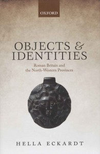
Congratulations to Dr Hella Eckardt, who has won the Faculty of Science prize for Best Research Output for her single author volume: Objects and Identities – Roman Britain and the North-western Provinces.

Hella’s book won the prize against stiff competition from all the Schools in the Faculty of Science. Ben Cosh, Dean of Science, described the book as an outstanding example of Reading’s world leading research in Heritage, Creativity & Values.  He went on to say: ‘As far as it is possible for a non-specialist to draw such a conclusion, it seems clear to me that you have introduced an entirely novel theoretical approach and methodology in the use of artefacts and the integration of archaeological evidence during consideration of fundamental aspects of our culture and heritage. I fully concur with the expectation expressed in the supporting nomination that this work will bring about a step-change in how artefacts are used in archaeological investigation and that, as such, it will have a major influence on the manner in which a range of social and economic questions are addressed by researchers worldwide.’


Travels to Tübingen

I’ve recently returned from Tübingen University in SW Germany: I had an invitation to visit from Professor Jörn Staecker, whom I’d last met when we were both giving lectures in Korkyt Ata Kyzylorda State University in Kazahkstan. Tübingen has a strong commitment to archaeology, with a research centre in medieval archaeology and I was also visiting because Reading has recently established a strategic partnership with the university to develop academic contacts. Last year Tübingen gained a prestigious government grant to run a multi-disciplinary research project on resources, their perception and exploitation. The project has many themes and some deal specifically with the medieval period: they involve the analysis of past landscapes in the area of the south Black Forest and the  impact of resource use and management by monasteries and castles in the area around the Bodensee (Lake Constance), on the border between Germany, Austria and Switzerland.

Tübingen Castle, the home of the university’s archaeology department

Tübingen Castle, the home of the university’s archaeology department

It was only in the 1180s that there was a general intensification of resource use and this could be related to the development of specific identities for both the urban workers and the peasantry which gave both the towns and countryside a different character.

I also had individual meetings with post-doctoral fellows and PhD students researching aspects of medieval landscapes and also workshops with other postgrad students working on the medieval aspects  of the resources project.

I also visited and discussed sites which I had long wanted to see, such as the great Cistercian monastery of Bebenhausen, where I was shown around by Christina Vossler who had written up the recent excavations for her PhD. We also visited the Benedictine monastery of Hirsau, famous for its pioneering  role in the spreading of the Cluniac reform in southern Germany. The monastery was founded in the early eleventh century and parts of that monastic church survive. However, by the end of the same century Hirsau had become such an important pilgrimage centre that a new monastery was built less than a kilometre away, a very unusual development. I was also shown Lichtenstein, the site of a medieval castle (surviving as a set of earthworks and some standing masonry) in a stunning and defensive position overlooking a steep-sided river valley. Close by there is a Gothick castle built in the 1840s by the Dukes of Würtemberg.

Bebenhausen: the abbey church

Bebenhausen: the abbey church

Archaeology (Palaeolithic, late prehistory, classical and medieval) is located in the castle of Tübingen , which probably originated in the eleventh century but was converted into a palace in the seventeenth century. It overlooks the historic town of Tübingen, which has a medieval market and collegiate church at its core and its streets are lined with large timber-framed town houses of the sixteenth century: in all, a remarkable survival of a late medieval town.

The nineteenth-century castle of Lichtenstein

The nineteenth-century castle of Lichtenstein

There will be further exchanges between the departments: Aleks Pluskowski and Alex Brown for example will go to Tübingen in January to talk about the Baltic Crusades project and Jörn Staecker will come to Reading for the first Medieval Social Archaeology Research Group workshop on religious transformations. Future exchanges for postgraduates were discussed as well as combined  undergraduate fieldtrips.


About today’s blogger

GrenvilleAstil_w Professor Grenville Astill specialises in monasticism, industry, urban and rural settlement in medieval North Western Europe. He leads one of the longest running and most extensive research projects on a medieval monastery at Bordesley Abbey (http://www.reading.ac.uk/bordesley/) alongside a reconsideration of the process of medieval urbanisation. He has also conducted a research project in Brittany which tracks change in the countryside from the later Bronze Age to the 1920s using a combination of archaeological, documentary and building evidence.