
 We now have access to Aerial Digimap, a new addition to the Digimap suite of mapping databases. It consists of detailed vertical aerial photography, which can be viewed, annotated, printed or downloaded. Maps are viewed in Aerial Roam as a single seamless coverage of Great Britain, with optional Ordnance Survey background mapping.
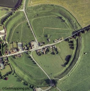
The imagery is provided by Getmapping plc in a jpg format, and can be printed at scales from 1:250 to 1:175,000. A sliding control in Aerial Roam allows you to choose how much of the background mapping you show, and the data will be regularly updated. Downloaded data can be combined in a geographical information system (GIS) with other Digimap data such as OS MasterMap or used to produce 3D models in conjunction with, for example, OS Terrain DTM.
Why should I use it?
 If you are studying archaeology it will aid visualisation of a site within its landscape, and may allow things not visible at ground level to be discerned.
- Environmental and biological scientists can use it to help to identify conservation areas and habitats, and to measure specific land uses.
- Studying architecture and urban planning? Use Aerial Digimap to view infrastructure networks, and to closely examine buildings using the detailed, 25 cm resolution of the imagery.
Using Aerial Digimap
To use Aerial Digimap you will need to accept the licence terms and conditions. It will prompt you to do this the first time you use it.
Help is available in the Digimap Resource Centre, and there are useful videos available on the Digimap YouTube channel. Alternatively, contact the Map Librarian for information and help.
Judith Fox, Map Librarian