
An enormous amount has happened since the last blog post, even though we only really started excavating into features yesterday! I have lots of really fabulous pictures to show you all that I hope will show you really clearly what kind of archaeology we are dealing with.

The rain comes down rather dramatically
We are now halfway through week two and have completed the first phase, cleaning back the trench by hand so that we can see the features properly.
This was a long, hot phase topped off by some extremely welcome but rather over-dramatic rain that brought out the different colours of the features really well. We all ran for cover as the clouds rolled over the excavation and it began to really pelt it down!
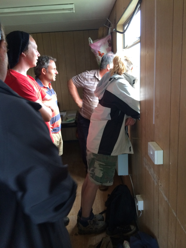
Supervisors and site director take cover and watch the storm
Although the rain was welcome, work had to come to a stop for a short time to make sure we didn’t give ourselves more work by churning up site by walking on it.
The rain did a fantastic job of clarifying the archaeology for us. Tayne Field is on a geology of chalk and an orange clay, which bakes hard in the hot sun to a grey colour, so it is important to have rain so that we can see the different colours of the archaeological features. If we don’t have a bit of rain now and again we have to water the site with a hose, and cover it up to keep the moisture in.
A final trowel over Trench 2 after quite a lot of rain on the weekend, ready for pre-excavation photography
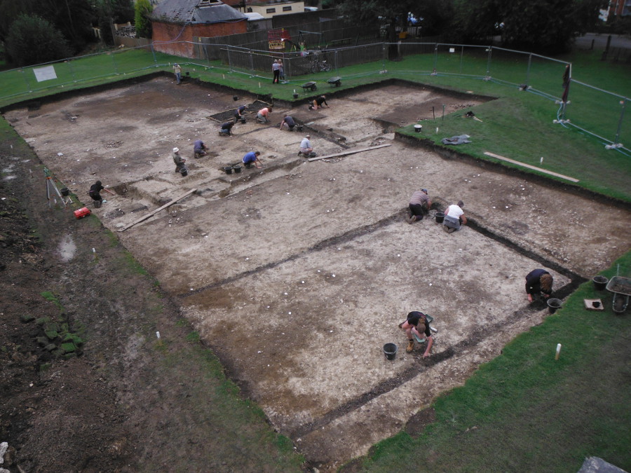
You should be able to spot all sorts of dark lines and circles against the whiter natural chalk bedrock in the photo above – these are post holes, ditches and wall trenches. The sharp black rectangular outline of the Second World War mess hut is particularly clear. After the rain, a quick trowel over to clear up silty patches and any loose spoil meant that we could move on quickly to the next phase – getting pre-excavation aerial and raised shots of the site prior to planning and excavation.

Alan sets up the drone for aerial photographs on the Jubilee plinth on Tayne Field
For this we set up a scaffold photo-tower (from which the above photo was taken), but we were also lucky enough to be able to bring in two helicopter drones to take really excellent views of the site. Here you can see the set up Alan from AD Photographics uses, quite a large drone with six blades but really great for getting fantastic vertical, steady images of the site.
The second drone was much smaller and manned by Andy Wood, who was able to get really excellent oblique shots showing the site in context with the rest of the village, incredibly helpful as it helps us understand the settlement within the wider landscape.
The vertical shots taken by Alan show up the Saxon archaeology incredibly well. This first image is taken of Trench 1, with the large circular ring ditch of the Bronze Age Barrow very clear. The spread of material currently understood to be a surface midden (otherwise known as ‘the blob’) is also really clear as the very dark area at the top of the photograph.
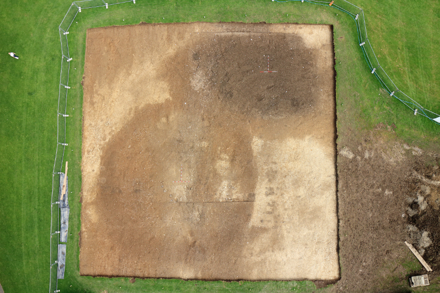
Aerial view of Trench 1 showing the ring ditch of the barrow, and a large midden in the top right (south-eastern) corner
You might also be able to spot smaller dots and patches that are likely to be associated post holes and other structural features that are part of the Saxon settlement.
The second trench is more complicated because of our previous excavations, but we have, as a result of the rain and some very careful troweling, identified the opposing wall of the timber hall discovered last year, as well as internal partitions and a possible doorway.

Aerial view of trench 2 taking by helicopter drone
This might look a bit mysterious, so I have edited the photo (see below) to show you where the large timber hall is. It runs underneather the end of our trench and a small brick built outbuilding that seems to be associated with the WW2 structures, and we won’t be able to excavate the full extent of the hall, but it is possible that the building was up to 30m long, if we have correctly identified the entranceway at this stage.
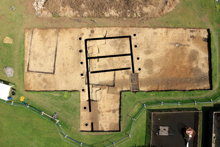
A quick sketch over the Timber Hall wall trenches and raking posts which can be hard to make out with everything that is going on in this trench.
Certainly we can tell that the width of the building was almost 10m, which promises the biggest hall that we have discovered thus far at Lyminge, even bigger than the feasting hall discovered in 2012 which was 21 m x 8.5 m!
The oblique photos taken by Andy show really well where we are in the landscape, so I can’t move on to other things without showing one of these photos too!
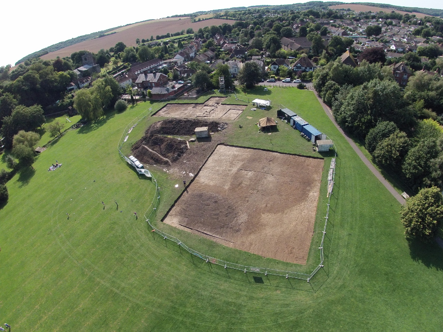
Putting our trenches into the landscape at Lyminge
The barrow is particularly clear in this image and you can spot the church to the left of the photo, behind which we excavated part of the monastic phase of the settlement at Lyminge in 2008 and 2009.
Opening the Environmental Test Pit down by the Nailbourne on Monday
If you’ve been following twitter or facebook you’ll know that in the last few days we started to properly excavate features, but we have also opened a small 2 m x 4 m test pit down by the stream. Simon, our environmental supervisor, is running this area as part of his PhD research investigating the landscape and environment of Lyminge throughout its occupation history.
Completely hand-dug by a team of delightfully muddy students and volunteers led by Simon and our new Assistant Environmental Supervisor Tom Gardner, this trench is giving us information we have never had before, as it goes below the water table.

A distinctly muddy test pit, below the water table next to the Nailbourne – we’re having to pump the water out as it creeps in to the trench!
So far the datable evidence suggests Saxo-Norman waterlogged features (several centuries later than our Anglo-Saxon settlement), with preserved wood, structural features such as stake holes and other evidence that we just don’t get in our dry, open area trenches on the plateau of Tayne Field – whole hazelnuts and other plant matter that will be invaluable when carefully analysed back in the lab.
Some lovely pieces of preserved wood have come up, and will be really useful for dating the different layers. The photo below shows a piece of oak in situ which associated pottery currently dates to c. 11th-12th centuries AD.

Heather and Toni examine the waterlogged oak, located just above the scale bar
A close-up of the piece of waterlogged oak found in the environmental test pit – click on the photo to enlarge
The pit is still under excavation so we do expect more news as they move into earlier layers and of course I’ll be keeping you all posted!
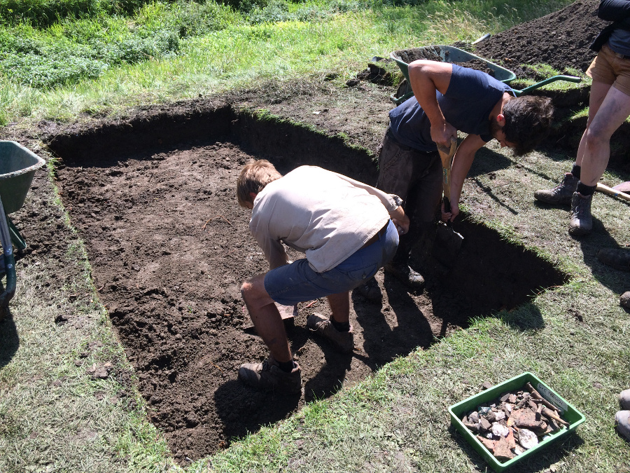
The photography done, pre-excavation planning and drawing of the trenches began in earnest, and excavation in our main trenches began yesterday with slots placed over the medieval ditch in Trench 2, and the beginning of excavation on the ‘Blob’, our possible surface midden spread in Trench 1. This stage of the excavation is always exciting as there are usually immediate finds and discoveries to cope with from the first scrape of the trowel into archaeological features.
Excavation has begun in earnest – Richard records a slot over a medieval ditch cut through by a 20th century brick building
We’re taking a slightly different approach to the excavation of the ‘blob’ in Trench 1 – it’s far too large to do as we usually dig and remove half of the feature to reveal the sequence of stratigraphy. This time we have divided up the area into 1m squares, and we are removing alternate squares to get a view through as much of this area as possible. We are taking each square down in 10cm ‘spits’ to make sure that we can record where all the artefacts come from as accurately as possible.
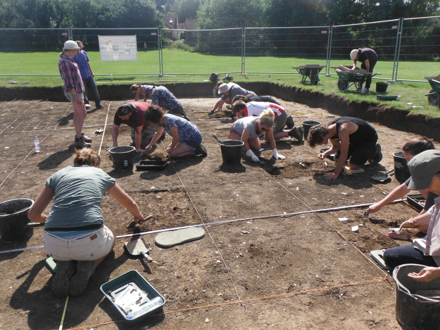
The ‘blob’ has been divided in 1m squares so we can record the distribution of finds over a large area
Ideally we will be able to verify whether we definitely have a surface midden (an area where rubbish and waste material has been collected), and whether the midden covers over other structures or features of an earlier date. Such middens are reasonably rare on Anglo-Saxon sites because they usually get ploughed away in the centuries following Saxon occupation. Tayne Field has been mostly pasture rather than ploughed land, which is why this area might have been preserved. Examples of surface middens exist at similarly dated sites like Bloodmoor Hill, Carlton Colville, in Suffolk.
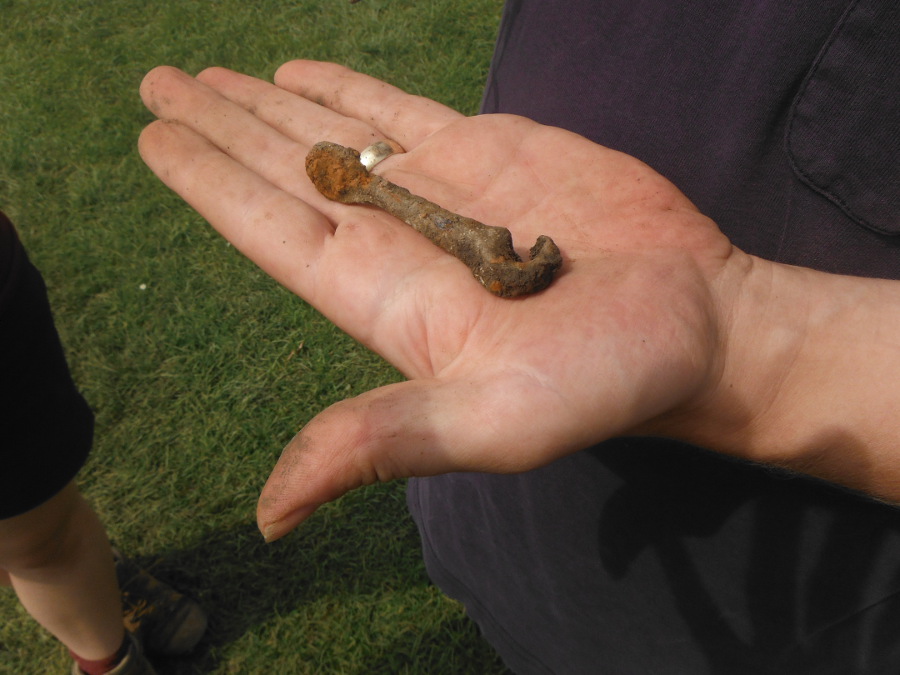
A very well preserved iron hook from the ‘blob’
Already we have had some lovely finds from this area, with pieces of glass, pottery and metalwork coming up. This lovely complete iron hook was found by Andrew yesterday, and today he clearly has kept his magic touch with the discovery of a complete square-headed Small Long Brooch just as I was wrapping up this blog post! It has ring and dot decoration and a beautifully preserved catch-plate on the back for it’s iron fastening pin.
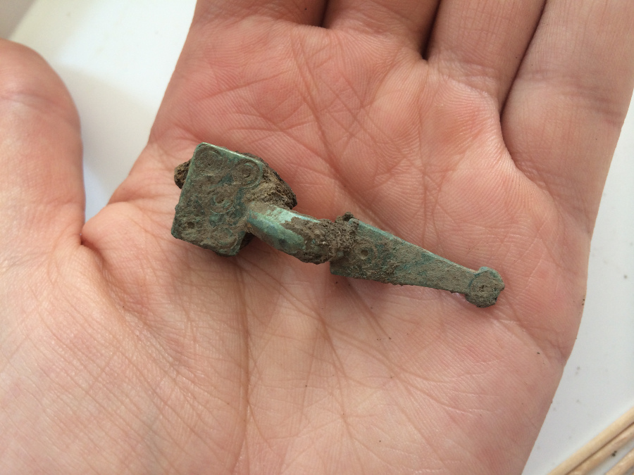
A beautifully preserved square-headed small long brooch excavated from the ‘blob’ or Anglo-Saxon surface midden
We’re really thrilled that this area of Anglo-Saxon material culture is throwing up such interesting and complete objects already. LYM14 is promising to be a very rewarding season both for buildings in the settlement and for artefacts!
How deep are surface middens generally? So many exciting things this year, it’s sounding like it will be the perfect send off for the final season! 🙂
Hi Courtney – they really vary depending on how much has been ploughed away and if features are present underneath them or they just fill a scoop or hollow. No definitive answer I’m afraid!
Wow this is exciting. moved way from the area in 1995 and never knew any of this existed in all the years I lived there. It was just Tayne Field. Hope you find lots information about previous occupants of the site.