Is the modern countryside a ‘vast museum’?

My colleague Alison Hilton (Marketing Officer) recently joined other museum professionals from around the UK at an event held in No. 11 Downing Street in celebration of the success of Museums at Night.

Alison Hilton, Marketing Officer

Alison Hilton (Marketing Officer) at No 11. Downing Street, April 2012

This visit from a member of MERL staff to the heart of government brought to mind something that I read recently, which had been penned by the current incumbent of the property next door, No. 10. The Spring 2012 edition of the Countryside Alliance quarterly magazine features a guest article by Prime Minister David Cameron (2012_Spring_Cameron), in which he writes enthusiastically about modern country life and refers to his own personal experience of different places within rural Britain. Here the PM draws attention to his own rural roots. He was brought up less than 20 miles walk from MERL, in the small West Berkshire village of Peasemore. Somewhat coincidentally, Peasemore just happens to be the location of the pub that will host the winner of MERL’s current photographic competition. I would urge you to enter this soon as the deadline of 22nd April is almost upon us.

Whilst attempting to avoid the political rhetoric of the PM’s article, I was nevertheless struck by a couple of things. Firstly, his characterisation of rural Britain as ‘a real place of mud and muck, proper community ties and incredibly hard-working people trying to make a go of their lives.’ This seems to echo the notion that the countryside might harbour potential to offer a renewed sense of social cohesion, about which I have already posted some thoughts. The piece also appears – albeit probably unintentionally – to echo language that was popular in critiques once levelled at the nascent organics movement of the 1940s, namely that this was an ethereal and unrealistic world of ‘muck and magic’! Putting this to one side for a moment, let’s take a look at how the PM then picks up on nostalgic and romantic ideas of the countryside, attempting to contextualise these within the complex social and economic climate of the present:

‘I love the beauty and history of the British landscape but for me rural life is part of the present, with huge strengths and serious challenges too… it is my constituency of Witney in West Oxfordshire where we [David Cameron and his family] are really at home. It’s a stunning bit of Britain, on the edge of the Cotswolds, with a real rural economy and thriving market towns. You can never forget, as an MP for a seat like mine, that the countryside isn’t a vast museum [my emphasis]. It’s a buzzing 21st-century economy.’

I think that it was the last section that I found particularly problematic. There is a casualness to the popular conception of museums as warehouses of the past that has the effect of pigeonholing them and portraying them as storehouse for objects, technologies, or ideas that were once important but are now redundant, once active but now static. However, much like the PM’s take on the countryside of the 21st-century, I would argue that museums are undeniably buzzing. What is more, they are waking up to their wider socio-economic potential and becoming increasingly effective at measuring their own impact, understanding their value as dynamic sites of engagement, recognising their potential to become active agents of change, and highlighting their important role as interconnecting hubs and facilitators of social enterprise. We don’t even have to look outside the rural museums sector to find the pioneers and architects of this latter approach. The Museum of East Anglian Life and its Director Tony Butler sit at the forefront of the Happy Museum Project, which seeks to bolster the social and economic importance of such institutions within their local communities, and to draw strength and inspiration from the values of people living in these places. So, far from being backward-looking institutions, museums are actually operating very much at the vanguard of David Cameron’s Big Society.

In addition, I would argue that the countryside can operate simultaneously as the ‘buzzing’ economy of the PM’s portrayal and concomitantly the enormous museum that he is keen to declaim against. Farmers and other managers of the landscape (alongside the many diverse people who work or live within it) are not only contributing towards a host of vital modern industries but participating in a vast exercise in stewardship and custodianship. Whether we travel through the countryside, talk about it, or even directly participate in and contribute towards it’s construction and care, we are all able to enjoy the fruits of these collective curatorial labours. This links back to some of the ideas that I think lay behind the very establishment of MERL. I believe that the museum’s founding father, John Higgs, probably drew inspiration from ideas about rural community and localisation that were popular with certain thinkers of the interwar period. This included people like H. J. Massingham, whose artefactual collections Higgs secured for his fledgling museum, and which have recently been fully catalogued as part of the Sense of Place project.

This notion of the nation as a vast open air museum is not really very new. It has links to the national park movement of the 1930s and arguably has its most explicit roots in ethnographic projects that preceded these developments. Indeed, I paid passing reference to one such vision in a recent article about folklore and object-collecting during the late-19th century:

‘On the threshold of a new century, one major folklorist argued that the entirety of British folklore should be thought of in museological terms, with the nation itself the museum and all its vernacular content and attributes—living and obsolete, tangible and ethereal—a distributed but systematic collection. Here the discpline itself became a museum; an historical project in which “specimens” were to be “labelled, ticketed, and set forth for greater convenience”.’

This is far from a redundant notion. I suggest it has a valuable role to play in the present and that the idea of ‘place’ should come to form a central part of how we begin think along these lines. Rural museums should seek to foster the idea of the countryside as a ‘vast museum’, thereby highlighting and capitalising on their own potential to function as key players in the broadening of public understanding about this rich interconnecting web of places, people, and activity. They can become portals, springboards, and stepping stones by which contemporary audiences can enter and begin to understand and enjoy the rural places that make up the massive countrywide display and interactive of Britain. There is nothing shameful in seeing the countryside in these terms. Instead, much like Museums at Night, this is something we should look to celebrate and encourage.

Articles cited:

  • David Cameron, ‘Last Word: My Countryside’ in Countryside Alliance, Spring 2012, p.42
  • Oliver Douglas, ‘Folklore, Survivals, and the Neo-Archaic: the Materialist Character of Late Nineteenth-century Homeland Ethnography’ in Museums History Journal 4:2, July 2011, pp.223-244
  • Alfred Nutt, ‘Presidential Address. Britain and Folklore’ in Folklore 10:1, 1899, pp.71-86 [as quoted in my own article]

Getting from place to place – Part 3

I was pleased to hear from my friend that he had been reading this blog, even proving keen enough to sign up for the RSS feed. As well as coping with the stresses of what can evidently be quite a harrowing commute, this particular friend has a busy work schedule and three young children at home. As such, I am surprised that has found time in his busy life to explore what we are up to. I guess it’s entirely possible that he is just humouring me, or perhaps he browses the web on the coach en route to London! Either way, as a roundabout way of thanking him for taking the time to look, I’ve decided to see if I can chart his commute in some way using artefacts, archival materials, and historic photographs from the museum’s collection. My motivations are not entirely altruistic. This is really an experiment to see if I can find interesting things that connect to and perhaps help to contextualise his route.

Here goes… As I don’t wish to reveal my friend’s precise address, I’ll start with a central feature of his home town Watlington, as depicted by Phillip Osborne Collier (1881-1979), a commercial photographer and postcard publisher who worked in Reading from around 1905 onwards. The Collier collection comprises circa 6000 glass plate negatives of places in Berkshire, Hampshire and Oxfordshire. These were produced between 1905 and the 1960s. Unfortunately, these Collier negatives have not been digitised in their entirety so for ease and rapidity of reproduction here I simply photographed them on a light box and inverted the image using editing software. They are therefore in quite a raw state but will hopefully give you some idea of the places depicted. So, lets imagine that my friend begins his day somewhere near to that central staple of English rural communities, the church:

The church in Watlington, as depicted by Collier

The church in Watlington, early 20th century

This prolific photographer’s glass plate negatives will lead on through the town and into the surrounding countryside. but the church is a nice way to start. My friend lives quite close to it and my family joined his on a visit to see the Christmas tree displays there last December. This provides me with an excuse to add in this Christmas card produced by Collier and featuring scenes from around Watlington:

Christmas card of Watlington, from the Collier collection

Watlington Christmas card, early 20th century

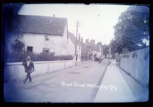
Turning back to my friend’s actual commute, it seems likely that he emerges, bleary-eyed, and cycles out into Brook Street:

Brook Street, Watlington, as taken by Collier

Brook Street, Watlington, early 20th century

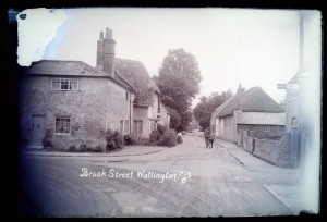
Because I’m uncertain as to where precisely on the modern-day Brook Street we are in this image, here’s another shot which I think may even show the exit from which my friend most likely emerges of a weekday:

Brook Street, Watlington, as taken by Collier

Brook Street, Watlington, early 20th century

I’m sure there are short cuts to be had but as I’m not privy to that fine-grained residential ‘sense of place’ I’m going to guess that from here my friend might turn left into Couching Street, perhaps even using the junction shown in the following photograph (if you look closely you’ll see that its signposted to Lewknor!). However, I suspect he doesn’t travel with a cyclist’s assistant like the distant subject of this image:

Brook Street and Couching Street, Watlington, as taken by Collier

Corner between Brook Street and Couching Street, Watlington, early 20th century

My friend’s commute takes him down Couching Street or in that general direction:

Couching Street, Watlington, as taken by Collier

Couching Street, Watlington, early 20th century

My friend almost certainly passes close to the old town hall and market place. Collier’s work includes two different views of this particular site, which also reveal subjects relevant to the navigational theme sthat I’m exploring here. The first shot features a horse-drawn vehicle:

Town Hall, Watlington, as taken by Collier

Town Hall, Watlington, early 20th century

By comparison, the second shot of this site shows early motor vehicles:

Market Place, Watlington, as taken by Collier

Market Place, Watlington, early 20th century

From here, both Collier and my friend head out into the surrounding countryside. For my friend to have a hilltop perspective like that shown below would entail an inconvenient detour (and possibly more sensible footwear again) but I’ve added this in anyway. It’s not often that the commuters amongst us have the time to take in a vista of our departure point, so I thought he might apppreciate the opportunity, even if the scene appears to be a little hazy as a result of my rushed digitisation:

Watlington from the hills, as taken by Collier

Watlington 'from the hills', early 20th century

My friend is now out into open countryside, cycling along the B4009 to Lewknor in order to make his bus connection. On the way he passes farmland that is representative of the agricultural community surrounding Watlington. An image (MERL P FW PH2/C108/62) in the museum’s Farmers Weekly photograph collection shows combine harvesters traversing a field close to the nearby village of Britwell Salome. This is not on my friend’s direct route but perhaps helps to communicate something of the kind of farming activity one might have seen in this area during the early 1950s.

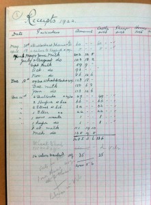
Back to our route, Pyrton is situated part-way between Watlington and Lewknor, northwest of the B4009. Somewhere beyond it lies Clare Hill, which was almost certainly the location of a place once called Clare Farm. The museum holds farm records related to this site, including a receipt book dating to 1922 and bearing the name of its then proprietor, Charles Hall:

Detail of ledger from Clare Farm, Pyrton

Detail of ledger from Clare Farm, Pyrton, 1922

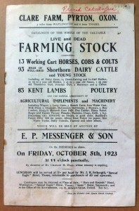
This set of archival papers also contains details of the sale of this same farm in 1923:

Sale catalogue for Clare Farm, Pyrton

Sale catalogue for Clare Farm, Pyrton, 1923

This is probably enough between Watlington and Lewknor (and I may well have exhausted the museum’s holdings relating to this particular area). Suffice to say, the museum appears to hold significant materials associated with the approximate route so far. From here the road takes my friend onwards between the fields to the centre of another nearby agricultural community at Lewknor. The museum holds an artefact – a musket – that was probably once used by a farmer in this very place:

Accession form for musket

Accession form for musket associated with Lewknor

This brings us to the end of my friend’s cycle ride and the beginning of his coach journey, which follows the motorway from Lewknor all the way to London. I suspect that there are probably numerous artefacts associated with different places situated along the route of the M40. However, my friend will probably have to wait until the project team have worked their data-enhancement magic and we have mapped these holdings in an easy to visualise way!

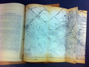
Lewknor detail on M40 planning map, 1960s

Lewknor on M40 planning map, 1960s

For now lets hope my friend is happy enough to learn of the fascinating papers that the museum holds concerning the impact planning for (and subsequent analysis of) this stretch of motorway, dating to between the 1960s and 1990s. These stem from the rich and detailed archives of the Council for the Protection of Rural England (now the Campaign to Protect Rural England), which include maps showing the intended route as well as papers and correspondence pertaining to the projected impact on the rural area affected:

Wider shot of Lewknor position on M40 map

Map showing proposed route (from Lewknor) of the M40, 1960s

Perhaps later in the project I will revisit this exercise to see what further material has come to light in relation to the M40 route. For now though, let me close with the obscure and limited content I managed to find to link to Shepherd’s Bush, which is more or less where my friend’s morning commute comes to an end. The museum catalogue reveals only a single archival item connected in some (unknown) way with this place. This is a drawing from the archive of the engineering company Charles Burrell & Sons Limited, the catalogue entry for which reads ‘Proposed Power House for Rolling Track (Shepherd’s Bush)’. This particular drawing relates to a rival engineeering firm making it even harder to determine what (and indeed where) this machine was intended for. Here is a detail of the drawing, which does not reveal a great deal more than the catalogue entry:

Detail from engineering drawing

Detail from engineering drawing

It is nice to end on an item linked with transport, as well as on something about whcih the museum does not currently know a great deal. If anyone knows more about how this vehicle would have been used please comment. The notion that underpins much of what this project (and indeed this exercise) is seeking to achieve is one of empowering the museum’s ‘source communities’ and harnessing the rich body of knowledge and ideas that the wider public can bring to bear on complex collections like thise held here at MERL.

Now I’m heading off to catch my train…

Is MERL ‘well-placed’ to foster social cohesion?

MERL is definitely not alone in recognising the value of focussing on place in relation to museums and their holdings. In the Spring 2012 newsletter of the Weald & Downland Open Air Museum, Vice-Chairman of Trustees John Godfrey raises interesting questions concerning recent social disorder within the UK and the need for young people to feel firmly rooted in the places they live. Exploring his own son’s direct experience of the London riots of 2011, he suggests that “what appears to be central to the disaffection and alienation of so many people… is the loss of a sense of place, of a common sense of shared ownership of the surroundings we share together: our shared landscapes, our shared buildings, our shared lives.” He goes on to make a compelling argument about the potential for the Weald & Downland to play a part in helping to facilitate a sense of place and belonging across society as a whole, and raises the important question of how the museum sector might contribute to developments of this kind:

‘I suggest that… the museum is well-placed to play a significant role in encouraging this sense of place amongst communities in South East England. The museum trustees, at their meeting in November, agreed a new mission statement for the museum as follows: ‘A centre of excellence for the enjoyment, learning and understanding of the built environment, landscape, rural life, and communities of South East England and the South Downs.’ But how do we fulfill this mission, how do we contribute to a growing understanding of the importance of locality in rebuilding social cohesion, trust and responsibility?’

I’m not sure that the MERL project has any firm solutions to offer at this early stage. However, once the data has been enhanced on the museum’s catalogue and the team have undertaken some trials both in the gallery and with our initial community partners, I think we might begin to offer some tentative answers. Our project is not seen as an end in itself but as a platform on which we hope to construct a new model for collections-centred engagement. By enriching the geographic data that underpins the museum’s digital resources and making these enhanced primary sources readily available, MERL can then begin to perfect the tools and techniques necessary to build lasting connections with people in locales where these materials are seen to have the most potential. This would certainly include some of the rural source communities where the artefacts already have an obvious resonance but might also include work with urban stakeholders drawn from the museum’s own doorstep. Here collections could become a useful tool in helping to ‘twin’ rural communities where a sense of place is arguably still manifest with urban areas where this sense of belonging is seen to be on the wane. Using museum collections as a focal point, the sharing of ideas about place and community might help MERL and its partners to foster greater social cohesion and a sense of shared custodianship.

To read the full column cited here see:

  • John Godfrey, ‘From the Vice-Chairman’, Weald & Downland Open Air Museum Magazine, Spring 2012, p.9 [earlier issues of this newsletter are archived here]

Hefting content onto HistoryPin

Since blogging about it, I’ve had a few conversations about the notion of hefting as a useful way of thinking about place. Extending this discussion offers a nice way for me to flag up one of the Museum’s existing partners – Historypin – and an opprtunity to encourage others to add photographic content to the Historypin site. It is particularly worth trying out some of the site’s augmented reality tools, which allow the user to overlay historic images (using Google Street View) and thus enable viewers to effectively fade between past and present. In an earlier post I also mentioned the farm in Stadhampton where my mother grew up – Brookhampton – and how this is a place that I feel a strange sense of connection to despite my only having visited since the farmhouse and steading were demolished. Historypin has enabled me to re-heft historic photos of Brookhampton, although I may need to consult family members in order to get the location exactly right!

Brookhampton Farm in the 1960s

Brookhampton Farm in the 1960s

Given my predilection for the metaphor of hefting I thought it appropriate to ‘pin’ an image of me as a youngster to the map. If you follow this link you will begin to see some of the challenges of pinning rural images and artefacts to Historypin. Rural views and objects are not necessarily connected to places that are visible from Google Street View, or indeed to easily ‘siteable’ places at all. I got my image about as close as I can manage, near to the old ‘stell’ (or dry stone sheep pen) that it depicts. If you look at the satellite view of the map you will see that there are several of these old features very close by. Although I’m fairly sure I know which one of these I am seen climbing on, I still can’t locate it precisely enough.

We hope to work closely with Historypin to begin to address some of the challenges that our project and the content it is generating might raise. We are also keen to begin pinning the museum’s artefactual collections to the places that they link to. Much like people though, objects have complex multi-sited biographies. The shepherd’s crook in the foreground of this picture is a perfect example of an artefact that is not only portable but is intended to be moved from place to place, offering a gentle reminder that outside of museum stores and displays, the things of everday life are not conveniently static!

Ollie Douglas as a youngster

At Heatherhope in the early 1980s

For those interested in the area surrounding where the image of me has been pinned, you will also see in satellite view that there is a reservoir not far to the west. This is the the old Kelso water supply. The sheep folds just to the east of where my portrait is pinned is known as Belsen. A shepherd who worked there shortly after the Second World War and who had been at the relief of Bergen-Belsen once came across the carcass of a sheep that had been left in the pen and forgotten about. He was heard to remark that the sight of this was ‘fair ******* Belsen’ and the folds has retained that name ever since. This story reminds me that there is more to place than just what we might see or the material links that we might have. The etymology and origins of placenames have a potent and valuable part to play in this discussion as well, not to mention the potential for places to gather negative as well as positive associations.

Cataloguing ‘place’…

Leaving my own thoughts on what a ‘sense of place’ means to another time, I’m going to talk a little bit about the practical issues we have encountered when putting geographic context about objects onto our database.

Having plenty of geographical context in the paper accession files, we had to decide how to put that information onto the database, and how to make it searchable.  We decided to create a hierarchy of places so that any specific place would, ideally, be linked to a county, region and country. Adlib, the database we’re working with, has a hierarchical capacity which enables us to do this. So, the geographical keyword (i.e. place) ‘Reading’ could be linked to ‘Berkshire’, for example.  This brought up the issue, however, of deciding what form our hierarchy should take.  Should we use a current list of contemporary administrative units, which include ‘unitary authorities’?  Or should we use the still commonly used ceremonial counties?  Long discussions threw up more and more ‘but what if…’ problems.  How would we put ‘the Cotswolds’ into a hierarchy, for example?  What about an object which arrived in the 1950s from Middlesex, a county which completely ceased to exist in the 1960s?

Throughout the course of these discussions, I discovered that my own understanding of the county system in the United Kingdom was woefully inaccurate.  In my defence, it really is quite confusing.  The ‘County of Herefordshire’, for example, is also a unitary authority, and the ‘City of London’ is apparently also a ceremonial county.  Aside from showing up my own lack of geographical understanding though, our discussions did raise an important point – how do our visitors, who will hopefully be using ‘place’ as a way to search and access the collections, understand ‘place’?

Eventually, we decided that the only way to achieve any sort of consistency in our cataloguing was to use a hierarchy based on contemporary administrative boundaries, and we have based ours on the hierarchy used in the online ‘Getty Thesaurus of Geographic Names’.  Bearing in mind some of the ‘problem places’ mentioned above, though, we have added in a number of other hierarchy levels.  These will hopefully enable us to both more accurately represent the level of contextual detail contained in the accession records, and make the hierarchy fit with as many understandings of ‘place’ as possible.

Places are therefore linked first to their ‘administrative unit’, but then also to their ceremonial county (if relevant) and region.  So ‘Reading’ is linked up to ‘Reading [unitary authority]’, which is linked to ‘Berkshire’, which is linked to ‘South East England’, and so on.  A lower level may also be added, that of ‘specific locale’, such as farm names, estate names and, where relevant, street names.  The problem places such as now non-existent counties and vague areas such as the ‘Cotswolds’ are still entered, but link straight to the country/countries they are in.  They are listed as ‘non-preferred terms’, showing that they should only be used when no other information is available, and also have a note which defines the area that they refer to.

It’s certainly not a perfect system, and we still regularly encounter new ‘but what if…’ problems, but we hope that eventually it will enable visitors to access information about ‘place’ in our collections in a way that is both consistent and logical, but also meaningful to them.

‘Hefting’ a sense of place – Part 4

By way of a final aside (and with Royal-themed matters in the pipeline for the MERL Village Fete later this year) I thought it might be nice to cite MERL’s own Royal Patron, HRH The Prince of Wales, who spoke on the subject of hefting to members of the farming community at a reception held in St James’s Palace on 29 January 2002:

“I wanted above all, to take this opportunity to salute you as part of the backbone of our precious countryside. As a consequence of the foot and mouth disaster many may have heard of hefted flocks for the first time and of the difficulty of re-establishing them once they have been removed. But do they realise that so many of you are actually hefted people – a crucial thread in the complex ‘organic’ tapestry that defines the essence of rural Britain? Unstitch that thread and the ancient tapestry will become featureless and abstracted; the countryside will lose that intangible element which comes from the continuity of wisdom and experience between generations. So I pray with all my heart that a way can be found for you and your children to continue caring for our unique landscape, and the special communities which form an intricate part of it.”  (Quoted in: Susan Haywood and Barbara Crossley The Hefted Farmer (Kirkby Stephen, Cumbria: Hayloft Publishing Ltd), 2005, p.5)

HRH Prince of Wales and Roy Brigden

HRH Prince of Wales and Roy Brigden

Please give it some thought and respond to this post to let us know where you feel most ‘hefted’ to and why. Are there objects and artefacts that remind you of places to which you have a connection?

If you are interested in more information on hefting and hill sheep farming, the following volumes are just some of the relevant literature available in the MERL library:

  • Susan Haywood and Barbara Crossley The Hefted Farmer (Kirkby Stephen, Cumbria: Hayloft Publishing Ltd, 2005)
  • Edward Hart The Practice of Hefting (Shropshire: The Farmers Fund, 2004)
  • Various authors Herding a Hill Hirsel: How to do it and how not to do it (Glasgow: Scottish Agricultural Publishing Co. Ltd, 1929

‘Hefting’ a sense of place – Part 3

In order for us to facilitate connectivity between collections and particular audiences it is vital that we first take steps to find out not only what we have but where it comes from, where it was used, where it was acquired, and any other places it may be in some way associated with. Of course, this may take us far beyond the bounds of England and it will begin to reveal the rich tapestry of local, national, and international relations from which the MERL collections emerged. Nevertheless, much like Roy Brigden’s connection with a new environment, or my own familial links with farming communities of the Scottish Borders, each of us understands place from their own subjective vantage point, wherever and whatever these diverse locales might be. As such, we must be mindful of not only the diversity of our collections but also of the multiplicity of reasons why our audiences may themselves feel hefted to particular places.

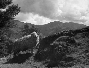
A Herdwick sheep

A Herdwick on a Lakeland farm

So, if nothing else these thoughts will hopefully encourage the wider curatorial community to embed place-related data in their catalogues wherever possible, and to capitalise on the potential for new avenues of engagement that might emerge from focussing purposefully on a ‘sense of place’. Through greater acknowledgement of the origins, use-history, and acquisition sources of museum holdings, such collections can be rendered applicable and relevant to particular locations, and re-located (or ‘hefted’) in relation to the modern-day communities within those places and spaces. Equally, for those audiences searching within museum stores or displays for a conceptual hook to render those resources relevant to them as an individual, what better way to maximise their chances of finding such a link than by making explicit the multitude of diverse places associated with the artefacts themselves.

‘Hefting’ a sense of place – Part 2

Despite the obvious relevance to the subject matter of this museum and links to my own personal heritage, what particularly intrigues me about the practice of hefting is the degree to which it’s proponents and practitioners (by which I mean the shepherds and rural people who maintain it rather than the sheep!) have as powerful and marked a sense of place as their ovine charges. This simple observation runs parallel to Roy Brigden’s reflections on hefting. He used the term to characterise the degree to which he had come to find himself indelibly linked to his adoptive countryside home. As individuals, we are hefted to many places for many different reasons. Many of us retain a strong sense of connection to the place(s) we grew up and most of us develop a new sense of belonging in other places as our lives progress. In addition, there are complex generational links to place, such as the sense of connection I feel to Stadhampton, Oxfordshire, where my mother grew up on a dairy farm. The project team have already enhanced data associated with at least one artefact from this village and, although it is a simple mouldboard from a plough, the fact that it comes from Stadhampton gives it a certain significance for me.

Catalogue card for a mouldboard

The original index card for a mouldboard from Stadhampton, Oxfordshire

I think that the simple metaphor of the ‘heft’ has much to offer social history museums (perhaps especially those of rural history) in terms of characterising the place-related ways in which audiences connect with collections. Thinking of things in these more lyrical and emotive ways may help us to create a more nuanced sense of place in relation to the collections we look after. Potential stakeholders in the MERL collections are numerous and include specialist interest groups and local audiences, both of which have often been fore-grounded in past engagement activities and projects. However, in recent years, ethnographic ideas and have brought the notion of source communities increasingly to the fore. Museum collections offer potential for tangible engagement with the pasts associated with places to which people are indelibly hefted through both familial ties and other connections. They also offer a means for people to begin to connect themselves to new locales, perhaps using material culture held in museums as a means of familiarising themselves with a new place of residence, and thereby cultivating a deeper sense of place.

‘Hefting’ a sense of place – Part 1

Since the project team started the data-enhancement, I think we have all begun to think more deeply about ideas concerned with place. We have begun to ask ourselves what it means to feel rooted in, connected to, or familiar with particular locales. When Roy Brigden (the former Keeper of this Museum) retired in 2010 he referred in his farewell speech to the practice of ‘hefting’. Perhaps unfamiliar to many readers, this is the process of intensively herding flocks of upland sheep until they become accustomed to a particular grazing area. Once hefted in this way, such groups retain a kind of homing instinct that lasts across generations. Such livestock often has a greater financial value. Perhaps more importantly for our purposes, it represents the durability of a hill farming practice that is centuries old.

A flock of Cheviot sheep

Gathering a hill flock at Lairg, Sutherland, in 1959

During the foot and mouth crisis of 2001 concern over the slaughter of hefted flocks was marked. In areas where the practice is most common (the north of England, the Scottish Borders, and parts of Wales) the impact of such decimation was seen in terms of not just the ruination of livelihoods but of unbroken traditions of herding being irreversibly interrupted, not to mention the difficulties associated with reinstating this system by training new flocks to recognise the old ground. As the son of a hill sheep farmer myself, I know a good deal about this practice and find it offers a useful way to begin conceptualising and characterising how I feel about the notion of ‘sense of place’ that gives name to this project.