
With the beginning of spring (either the ‘meteorological’ spring on 1 March or the ‘astronomical’ spring on 20 March, as the Met Office explains here), the UK and indeed the whole Northern Hemisphere start experiencing warmer weather. The next few days are forecast to see settled weather over the UK with warm temperatures during the day, chilly overnight. This will be in part due to the prevalent large-scale atmospheric conditions, featuring what is called an episode of atmospheric blocking. An atmospheric block is a long-lived, usually more than five days, high-pressure system that remains almost stationary over a particular region. While the high-pressure system is there, other sources of weather variability such as mid-latitude cyclones and storms are deflected either to the north or to the south, so that the block acts as a shield for the blocked region against wet and windy weather. This might sound good, but if the blocking conditions remain for too long, this might lead to heat waves and drought in summer or very cold temperatures in winter.
Even though these blocks depend on the large-scale atmospheric conditions, which are generally easier to forecast than conditions at a particular location, forecasting the time when a blocking episode will start or finish is notoriously difficult. Figure 1 is an example of a blocking episode over Scandinavia, observed during the field campaign of the North Atlantic Waveguide and Downstream Impacts Experiment (NAWDEX, see also the blog entry on 31 October 2016). The blocking episode properly began on 4 October 2016 and remained there at least until 17 October. Two blobs representing atmospheric blocking on 4 October 2016, one over Greenland and a second one over Scandinavia, can be seen in Figure 1.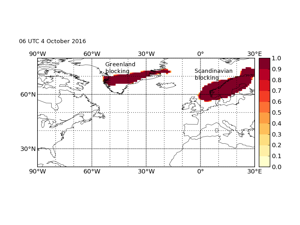 Figure 1. Atmospheric blocking over the North Atlantic and Europe on 4 October 2016.
Figure 2 represents the same day, but as it appeared in the forecast six days earlier (i.e. the forecast issued on 28 September 2016). The colour shading represents the probability of having a block. White represents zero probability of a block; light yellow represents a very low probability of a block; dark red represents a very high probability of a having a block. The shading over Scandinavia indicated that a blocking over that region was almost equally likely to happen or not happen. Furthermore, the forecast is not at all confident about the occurrence of blocking over Greenland. In addition to these two locations, there was a very small but non-zero chance of blocking over Spain and a few other spots over Canada and the North Atlantic.

Figure 2. Atmospheric blocking over the North Atlantic and Europe on 4 October 2016 as forecast six days before on 28 September 2016.
Researchers at the Department of Meteorology and as part of the NAWDEX project are investigating the causes for the low blocking forecast skill in forecasts beyond five days and whether it is possible to improve it. It very well may be that this aspect of the atmosphere is actually unpredictable at those time scales, or it might be that we can improve our numerical models better to represent this phenomenon. Being able to predict blocking with confidence more days in advance would bring benefits such as planning ahead for the extreme weather conditions (e.g. heat waves, cold spells and drought) that might arise as a result. This makes the endeavour of improving blocking forecasts worth pursuing.
At the time of writing this blog entry, the 5-day forecast indicated that the current block over the UK should end on Monday 10 April, while a new strong block was forecast to be located over the North Atlantic. I am curious to know whether the forecast was correct or not.