A new DfID funded Forecast-based Action project led by Emily Wilkinson from the FATHUM team

Author: Emily Wilkinson, Overseas Development Institute

A range of large scale social protection and risk finance initiatives as well as promising innovations in forecast-based action (FbA) have emerged in recent years. This field of forecast-based early action is rapidly expanding, and consolidating the evidence, experience, and lessons from early efforts to develop forecast-based action and finance tools can help improve the impacts and effectiveness of future investments.

The Scoping and Design for Taking Forecast-Based Early Action to Scale project funded under the WISER programme will do just that. ODI and partners including the University of Sussex, the START Network, the Red Cross Red Crescent Climate Centre, and Tetra Tech, will work together to review and share existing forecasting and decision-making capabilities and links to finance for early action that can be triggered in a range of different contexts. The project team will identify opportunities for institutionalising early action through modifications to existing delivery systems, carefully designed in partnership with relevant stakeholders.

Three focal studies will be selected to reflect a variety of early action financing and delivery mechanisms. The goal of the focal studies will be to (a) uncover the political economy and other factors influencing the formalisation of FbA mechanisms; and (b) build interest and dialogue between key stakeholders (providers of forecasts and potential users of that information). Research will cover up to three types of ‘systems’: an international financing mechanism; a national delivery system (in a stable institutional context); and through non-state actors (in a fragile context). The completed Focal Studies report will set out the context and rationale for scaling up in each system and describe the process of co-production used to bring together the necessary stakeholders to develop a sound concept.

FATHUM Fieldtrip to Amuria District in Uganda, Friday 22nd to Sunday 24th September 2017

Author(s): Carinus de Kock (Stellenbosch University), Harriet Aber (Makerere University), and Joy Waddell (Stellenbosch University)

Map of the fieldtrip route from Kampala to Apeduru and Okoboi villages in north-eastern Uganda (via Google)

As part of the fieldtrip, we visited the villages of Apeduru (in Amuria County, Asamuk Sub-County, Ajaki Parish) and Okoboi (in Kapelebyong County, Kapelebyong Sub-County, Okoboi Parish). Both of these villages are located in the Amuria District, Teso Sub-Region, 330km and 370km northeast from the country capital of Kampala, respectively. These rural village communities are extremely remote and lack basic infrastructure such as tarred roads, electricity, stormwater and water services. The town of Soroti, where we stayed for the duration of the fieldtrip, is 42km from Apeduru village, and the closest town for many essential services. Although there is fairly good cellphone coverage, many people living in these areas do not possess cellphones.

Basic infrastructure in the trading centre in Amuria district

Electricity power lines and an MTN Mobile(phone) money kiosk (a common mode of money transfer in the district because of a lack of banks)

Flooding, drought and diseases were identified as the most prevalent hazards in the two areas visited, as well as many surrounding areas. Contributing factors include rain that flows from the higher lying areas to the north such as Kabong, Moroto, Kotido and Nakapiripit districts in the Karamoja sub-region, and even Kenya, to low-lying, flat, swampy areas. Furthermore, it was indicated that soils in the area have a low water permeability and therefore maintains a high water table. The photos below show the main road to Apeduru and the high water level from heavy rainfall in Okoboi parish, which fell 2-3 days before the fieldtrip and caused severe waterlogging. The following impacts from the waterlogging were reported: 781 gardens and 7 houses were destroyed, and 24 households were relocated to higher ground. During heavy rainfall periods such as the one experienced prior to this fieldtrip, communities in these areas are often at risk of being cut off, with no access to main towns, neighbouring villages, nor incoming relief.

Rising water alongside the main road to Apeduru village

Flooded main road to Apeduru village

During group discussions with residents from Apeduru and Okoboi villages, residents indicated that the Uganda Red Cross has provided significant assistance during floods, such as flood-resistant housing. Furthermore, through environmental education and awareness, such as discussion on the most suitable crops and planting seasons, the Uganda Red Cross has built capacity and increased people’s preparedness to disaster risk. Unfortunately, due to standing water and damp conditions caused by flooding, diseases such as malaria, pneumonia, and foot-and-mouth are still prevalent in these areas. Waterlogging is also a major hazard that impacts negatively on local farming and agriculture. Residents from Okoboi village indicated that gender inequality in still prevalent, with men and women having specific roles and there being no gender cooperation; women, for example, are often excluded from critical decision-making processes.

Group discussion in Apeduru village

Group discussion in Okoboi village

During the group discussions, the communities highlighted a number of needs during this waterlogging event: tarpaulins for drying crops since their compounds are waterlogged; water purifiers for water treatment; mosquito nets and mosquito residual spraying; adequate water points since current water points are shared between people and their cattle; access to seed of fast-maturing crops; and gumboots and saucepans. The photo below shows water collection at a communal borehole, which is often shared with neighbouring villages and causes conflict during the dry season.

Water collection point in Apeduru village

During the group discussions, the two communities noted that prior to Red Cross intervention, they had their own indigenous knowledge for coping with water logging. The interventions they carried out included erecting bed stands in cases of flooding, and using iron sheets as flood covers. Since the intervention of FbF, they now have access to safer shelter and have learned how to dig trenches before flooding. These communities also attributed the reduction of malaria cases and waterborne diseases to the FbF intervention. The Red Cross also carried out other interventions in these areas, including environmental conservation, adopting and using energy-saving stoves, and provisions of soap, jerry cans, water tables, and garden hand-hoes.

We want to thank the Red Cross officials, and the local communities and their leaders for giving us their time and for their willingness to discuss some of the issues that they face during flood events.

Forecast-based Financing in Nepal

Author(s): Liz Stephens (University of Reading)

An interesting comment piece from Madhab Uprety, Disaster Risk Reduction consultant, and Sumit Dugar, Research Associate at Practical Action Consulting South Asia on the recent floods in Nepal has been posted here.

It is no surprise that a similar situation has been encountered in Nepal as elsewhere in the world:

It is largely unclear among the humanitarian actors and government stakeholders about what levels of forecast probabilities and magnitude are worthy to react.

You may be interested in connecting with the Practical Action project team to compare and contrast how Forecast-based Financing is being implemented in Nepal compared to our own pilot projects in Uganda and Mozambique:

Practical Action together with support from the World Food Program have been advocating this approach in Nepal and the idea has already been put-forth across national Disaster Risk Reduction (DRR) platforms for discussion. FbF is currently being piloted in six flood prone districts of West Nepal and there is an intention to upscale these initiatives across entire southern flood plains of Nepal. Forecast thresholds and triggers have been identified and Standard Operating Procedures (SoPs) that includes science informed anticipatory actions have been developed and integrated in the local disaster preparedness plans.

Sumit Dugar is part of the project team of the SHEAR LANDSLIDE-EVO project, and is keen to connect with the FATHUM team. We will shortly be advertising a PhD project to work alongside the FATHUM team, focussed on supporting Forecast-based Financing in Nepal. The student would link with Practical Action Nepal and the Nepal Department of Hydrology and Meteorology.

Introduction to South Africa case study

Author(s): Joy Waddell, Ailsa Holloway, Carinus de Kock (Stellenbosch University)

The FATHUM team in South Africa has selected the Langeberg Municipality in the Western Cape as the case study site for this research. South Africa’s Western Cape, which is home to over five million people, is known as “the Cape of Storms.” Due to the Langeberg Municipality’s extensive disaster history, steep topography, and remoteness of its rural communities, it was identified as a hotspot for high-impact weather events that increase the likelihood of destructive flash flooding. The Langeberg Municipality, which is one of five local municipalities within the Cape Winelands District of the Western Cape, is located about 180 km east of Cape Town.

Location of the Langeberg Municipality in the Western Cape, South Africa

The Langeberg Municipality has a population of 98,000 involved in a diverse economic base that includes mainly agriculture, forestry, and fisheries (15.3% of GDP, 23.1% of workforce in 2014), tourism, and manufacturing (17.5% of GDP in 2015). The Langeberg’s major towns (Montagu, Robertson, Ashton, and Bonnievale) are surrounded by complex mountain topography. The steep gradient of these mountains and the elongated and lobed shapes of the catchments in this area increase the likelihood of flooding, particularly flash flooding.

Mountainous terrain in the Langkloof, Langeberg Municipality

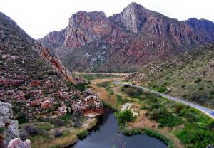
River’s proximity to the Cogmanskloof pass, near Montagu

From 2003 to 2014, the Langeberg Municipality experienced six disasters associated with severe weather events caused by cut-off low pressure weather systems. The resulting disasters were characterised by widespread flooding, with impacts reported across the Western Cape. During that time, the Langeberg reported total financial losses of around ZAR 23.6 million, with 6,424 people affected or requiring assistance.

Flooding in Aston, 2003

Number of people affected in the Langerberg Municipality from disasters associated with cut-off low systems

The town of Montagu, with its population of 15,176, is situated at the confluence of two major rivers. The Cogmanskloof pass through the Langeberg Mountains, near Montagu, is a major road that has flooded, cutting off the northern and southern parts of the Langeberg and causing logistical challenges, especially for response units such as emergency services, disaster management, police, and traffic services during a disaster.
Other contributing factors increasing local flood risk include:
• Changing land-use patterns, which increase surface run-off;
• Location of many towns and critical infrastructure along major rivers and in river valleys;
• Frequent wildfires linked to fire-adapted vegetation (e.g., fynbos, grasslands, Rynosterveld) and alien vegetation (e.g., pine forests), which also increase surface run-off;
• Increasing sediment accumulation (aggradation) in rivers, also linked to increased alien vegetation (e.g., reeds) in riparian zones.

Debris clogging a bridge leading into Montagu, 2015

Damage at Cogmanskloof pass, 2015

There is limited weather radar coverage in the Western Cape, not only because there are not enough instruments in place collecting the data, but the mountainous topography means that accurate inland flash-flood forecasting is blocked by the Langeberg mountain range, As shown in the Figure below, this leaves very little of the Western Cape covered by accurate weather radar, which severely restrains accurate forecasting and warning in the province. The implications were clearly highlighted during the 2011 and 2012 events, when weather warnings disseminated by the South African Weather Service did not specify areas such as the Langeberg Municipality. Heavy rainfall and flooding events in the Langeberg’s towns, such as Ashton, Montagu, and Robertson, claimed several lives, including that of an ambulance attendant. In both instances, preparedness mechanisms that should have been activated were not triggered, as flash flood warnings were not issued for the Langeberg Municipality.

Map of the Western Cape, highlighting the optimal weather radar coverage (green and white circles), compared with actual coverage (red shading) (Taken from Pharoah et al. 2016)

For more information on cut-off low weather systems in the Western Cape and their impact on the Langeberg Municipality, see: Pharoah et al. (2016). “Off the radar: Synthesis report. Severe weather events 2011-2014 and their impacts in the Western Cape Province, South Africa.”  http://pdf.usaid.gov/pdf_docs/PA00M95M.pdf

Should seasonal rainfall forecasts be used for flood preparedness?

The first paper from members of the FATHUM team has now been accepted for publication!

Coughlan de Perez, E.Stephens, E.Bischiniotis, K.van Aalst, M.van den Hurk, B.Mason, S.Nissan, H. and Pappenberger, F. (2017) Should seasonal rainfall forecasts be used for flood preparedness? Hydrology and Earth System Sciences. ISSN 1027-5606 (In Press)

https://doi.org/10.5194/hess-2017-40

Abstract

In light of strong encouragement for disaster managers to use climate services for flood preparation, we question whether seasonal rainfall forecasts should indeed be used as indicators of the likelihood of flooding. Here, we investigate the primary drivers of flooding at the seasonal timescale across sub-Saharan Africa. Given the sparsity of hydrological observations, we input bias-corrected reanalysis rainfall into the Global Flood Awareness System to identify seasonal indicators of floodiness. Results demonstrate that in wet climates, even a perfect tercile forecast of seasonal total rainfall would provide little to no indication of the seasonal likelihood of flooding. The number of extreme events within a season shows the highest correlations with floodiness consistently across regions. Otherwise, results vary across climate regimes: floodiness in arid regions in Southern and Eastern Africa shows the strongest correlations with seasonal average soil moisture and seasonal total rainfall. Floodiness in wetter climates of West and Central Africa and Madagascar shows the strongest relationship with measures of the intensity of seasonal rainfall. Measures of rainfall patterns, such as the length of dry spells, are least related to seasonal floodiness across the continent. Ultimately, identifying the drivers of seasonal flooding can be used to improve forecast information for flood preparedness, and avoid misleading decision-makers.

Kick-off Meeting Report

The FATHUM Kick-Off meeting was held from July 3rd to July 5th 2017.

Monday 3rd July

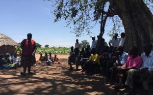
Icebreaker activities and discussion: The FATHUM team had 1-on-1 speed-introductions to each other, trying to find the most interesting / novel thing they had in common. Then they were asked to ‘vote with their feet’, placing themselves in different parts of the room depending on their disciplinary background, applied or theoretical nature of research, and previous history of working with the Red Cross / Red Crescent Movement.

Quiz the Panel: what is Forecast-based Financing? Erin Coughlan de Perez spoke about the history of FbF and why the concept was developed. Irene Amuron spoke about her experience implementing FbF in Uganda. Liz Stephens discussed her view as a scientist advising on the first FbF pilot projects.

Where is Forecast-based Financing now? Erin was quizzed by the group on all the other FbF related activities, including the Dialogue Platform events and the FbF Manual – fbf.drk.de, to which FATHUM research will contribute.

Presentation from Liz Stephens: Introduction FATHUM

Interdisciplinarity Exercise: The team were invited to think about  what methods we could adopt  as a team to overcome the challenges of interdisciplinary working. We decided on 5 rules to promote interdisciplinary research within FATHUM, along with developing a Glossary of Terms to enable better communication and understanding across our disciplines.

Website exercise: the team were asked for their priorities for the FATHUM website.

FATHUM Advisory Board Meeting: in person & via skype

Tuesday 4th July

Presentation from Hannah ClokeWork Package 1 Overview Probabilistic Forecasts Game: Andrea Ficchi led small teams through a game to highlight the challenges of decision-making from probabilistic forecasts.

Discussion topic: what is needed from a forecast? Andrea Ficchi asked for different perspectives on the required spatial scale of forecasts.

Impact Activity:  Pablo Suarez asked the project team to imagine an important mentor in their life, and what they would tell them about the FATHUM project., then to imagine bumping into a fellow team member in 25 years time; what successes would they like to be reflecting on.

Presentation from Liz Stephens: Project & Impact Deliverables

Work Package 3 Activity: Sara de Wit led groups organised by discipline in a ‘mapping the conversation’ exercise, discussing “What makes a successful implementation of FbF”, and “What are the barriers to FbF being implemented?”

Open Event with other projects from the SHEAR programme and at the University of Reading

Wednesday 5th July

Presentation from Ailsa Holloway: Work Package 2 Overview .

Presentations from Ailsa, Chris and Benedita on the WP2 case studies in South Africa, Uganda and Mozambique. Followed by a fruitful discussion about these case studies.

Presentation from Emily Wilkinson: Work Package 4 Overview. Followed by small group discussions on the how, what and where of upscaling.

Meeting reflections: Erin asked the team for their ‘I like’, ‘I wish’, and ‘I wonder’ feedback on the kick-off meeting. Liz asked for the team to reflect on what they will plan to do ‘on the way home’, ‘in the next month’, and ‘by the next meeting’.

Key Future Activities

*31st August deadline for SHEAR studentship proposals*

*Methodology meeting in Kampala 22nd-26th September 2017*

*Website soon to go live at  www.reading.ac.uk/fathum*

*FbF Dialogue Platform meeting in Nairobi in December / January (to be confirmed)*

*Adaptation Futures conference in Cape Town / FATHUM Year 2 meeting in Stellenbosch from June 18th 2018*