
![]() We now have access to a new service as part of Digimap, available both through Digimap Roam and Download. Geomni consists of three parts, all of which can be accessed through the basemaps button on Roam.
We now have access to a new service as part of Digimap, available both through Digimap Roam and Download. Geomni consists of three parts, all of which can be accessed through the basemaps button on Roam.
- UKMap: a modern, highly detailed, feature-rich mapping database of Greater London. Its unique, innovative design offers users a flexible choice of integrated map features within a single geographic information source.
- UKBuildings: a unique database created and regularly updated to help you understand the age, structure, characteristics and use of commercial, public and residential buildings across GB.
- UKLand: a maintained, national land information database providing a detailed consistent breakdown of the use of land across the UK
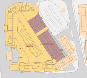
UKMap (London)
UKMap, despite its name, actually covers London within the M25. There are several different parts. In Roam use Basemaps to find:
- Base (London) – similar to OS MasterMap but with more land use information. Includes unit information within shopping centres.
- Aerial (London) – at a resolution of 10 metres.
In addition, using the Overlay tab, you can add:
- Upper Floors (London) – shows content of upper floors of shopping centres
- Tree Canopy (London) – shows indicative canopy of trees
Download gives two more Greater London datasets:
- Terrain DTM – Digital Terrain Model
- Terrain DSM – Digital Surface Model

UKBuildings.
UKBuildings is a national database of building attributes. It includes information about building area and height, as well as relative age (eg Historic, Post War, Modern) and use (eg Residential, Religious, Retail with offices above).
UKLand is a national database of land use (rather than cover). It allows the identification types of land use eg mines/spoil areas or business and retail parks and could be used for planning and risk assessment.

UKLand
To access Geomni, go to Digimap – you will need to register and accept the licence conditions first.
Judith Fox, Map Librarian