Making the most of our map resources – info tip

Field mapsDid you know that University of Reading Library has more than 70,000 maps and atlases and is one of the largest university collections in the country? Our maps can be used for your teaching, research, and holidays!

Geographical cover

We have excellent coverage of Britain, including detailed coverage of Berkshire and the Reading area. Coverage of Europe is also very good, at least to road map level of most countries.

Coverage of the rest of the world varies with what is available – it may not be possible to obtain recent maps of some areas, especially as many governments consider maps to be politically sensitive. However we will certainly have something for all parts of the globe.

Date range

Reading 1761Although the collection is mostly post-1900, we have many facsimiles of earlier maps, including reproductions of English 18th century county atlases.

We also have Ordnance Survey maps dating back to 1830, as well as access to Historic Digimap, so it is possible to produce a time sequence of maps of a particular place.

Older versions of atlases and maps may reveal hidden information about a place and its past.

Types of map

You need to consider the type of map you need, and what you are planning to do with it.  Maps come in a variety of different types:

  •     Sheet maps or atlases
  •     Flat or folded
  •     Loanable or reference
  •     General purpose or thematic
  •     Paper or digital

Atlases are generally available for loan, and are mostly found in the 912 and FOLIO–912 sequences on the 2nd Floor.

Most of the map collection is non-loan, but a set of folded ‘Field maps’, including British Landranger and geology maps, are available for loan on the 2nd Floor.

Thematic maps show geology, soil types, land use, population, languages – anything which can be shown with a spatial distribution.  Many maps of this type are included in atlases, but may also be found as sheet maps.

Digital maps

roam TowerDigital maps are of increasing importance. For Great Britain, Digimap delivers maps and map data from official sources to UK higher education, and you can easily create authoritative location and site maps.  There are five different collections available to members of the University of Reading:

  • Digimap – contemporary Ordnance Survey maps and data, ranging from small scale base maps to detailed large scale plans
  • Historic Digimap – historic Ordnance Survey maps from 1840 to the 1990s.  They can be compared side-by-side to help follow changes in the landscape
  • Geology Digimap – geology maps and data from the British Geological Survey (BGS)
  • Environment Digimap – landcover maps for different years, from the Centre of Ecology and Hydrology (CEH).  This collection includes scans of the Dudley Stamp Land Use maps from the 1930s
  • Aerial Digimap – detailed aerial photography in a single seamless coverage, captured since 2000

A simple print out can be produced, or data can be downloaded and used in a Geographical Information System in conjunction with your own data. Look at the GIS & remote sensing section of our LibGuide to find other online sources of digital maps and data.

How to find them

To find paper maps the first step is to search the Enterprise catalogue. Search for the location you want, then refine using the format in the ‘Limit these results’ function to include only maps and atlases (atlases are listed separately – you may need to select ‘more’ to see all the options). Try not to be too specific – a more general search will produce better results.

For more information about searching for maps in Enterprise, and maps in general see the Maps LibGuide.

You can also see our short video presentation, Using maps for your research in University of Reading Library.

Or you can ask the Map Librarian! I am happy to help –  email me for an appointment, or find me at the 3rd Floor Information Desk.

This is one of a series of tips to help you save time and effort finding or using information.

This tip was written by Judith Fox, Map Librarian.
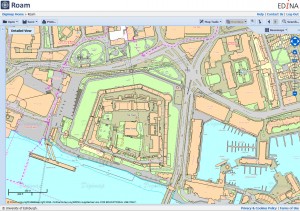
Video for teaching and learning – find out more at TEL Fest 2017!

Recently we posted our Info Tip about some of our great Video streaming resources that you can use in lectures and course materials to engage students and bring some variety to your teaching and learning. If you are a member of Staff at University of Reading and would like to find out more the Library will be getting involved with some of the events at this week’s TEL Fest 2017!

Tuesday 11 July, 13:00-14:00 we’ll be at the TEL Roadshow to talk informally about Box of Broadcasts and how you can use it in lectures, reading lists and BlackBoard. Come and join us in Carrington 201- no need to book, just drop in at 13:00 for a bite to eat and a chat!

Thursday 13 July, 14:30-16:00 Markeda Cole from Learning on Screen is presenting: Bob’s your uncle! Using TV & radio programmes from Box of Broadcasts to enhance T & L – more information and how to book a place on this session

So come along and get involved in the festival experience!

Natalie Guest, Multimedia manager

Do you use Lidar? New data trial in Digimap

LidarDigimap have announced a trial of a new service – Digimap Lidar. Download Lidar data for England, Scotland and Wales as Digital Terrain Models, Digital Surface Models and the raw LAS point file data.

The data will be available until July 31 – for more information see the Digimap blog post.

If you are using or intend to use Lidar in your research, have a look at what’s there and fill in the short survey – you could win a £20 Amazon voucher!

3D scene with Aerial imagery and Lidar

3D scene showing imagery with hillshading derived from the 50cm Lidar DSM. © Getmapping Plc, © Environment Agency copyright and/or database right 2015. All rights reserved.

Judith Fox, Map Librarian

Need maps? Try Digimap – info tip

If you need maps of Great Britain, think aDigimapbout using Digimap – Digimap delivers maps and map data from official sources to UK higher education, and you can easily create authoratative location and site maps.  There are five different collections available to members of the University of Reading:

  • historic_promo_smallDigimap – contemporary Ordnance Survey maps and data, ranging from small scale base maps to detailed large scale plans
  • Historic Digimap – historic Ordnance Survey maps from 1840 to the 1990s.  They can be compared side-by-side to help follow changes in the landscape
  • Geology Digimap – geology maps and data from the British Geological Survey (BGS)
  • Environment Digimap – landcover maps for different years, from the Centre of Ecology and Hydrology (CEH).  This collection includes scans of the Dudley Stamp Land Use maps from the 1930s
  • Aerial Digimap – contemporary aerial photography from Getmapping plc.

You will need to register to use Digimap – it is quick and easy to do.  Follow the instructions on our Digimap page.

geology_promo_smallOnce registered, you can select and print maps of Great Britain using the ‘Roam’ interface from whichever collection you want.  Roam includes tools to annotate your maps, and you can save them for future use. You can also measure distances and areas. Printing is possible at sizes from A4 up to A0, or you can save it as a pdf or a jpg to insert in Word.

If you prefer, you can download the map data to use in a Geographical Information System such as ArcGIS or QGIS.

environment_promo_smallExtensive help is available from the Digimap Resource Centre and from the Digimap YouTube channel, or you can email your Site Representative – Judith Fox, the Map Librarian.

To find out more about maps in the Library see our Maps guide.

This is one of a series of tips to help save you time and effort finding or using information

This tip was written by Judith Fox, Map Librarian

Eye spy… try out our new resource showing Britain from the air

Avebury Aerial Digimap
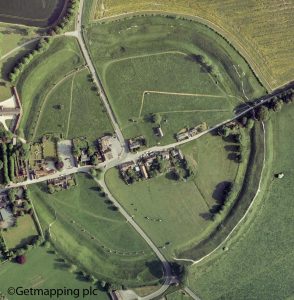
We now have access to Aerial Digimap, a new addition to the Digimap suite of mapping databases. It consists of detailed vertical aerial photography, which can be viewed, annotated, printed or downloaded.  Maps are viewed in Aerial Roam as a single seamless coverage of Great Britain, with optional Ordnance Survey background mapping.

The imagery is provided by Getmapping plc in a jpg format, and can be printed at scales from 1:250 to 1:175,000. A sliding control in Aerial Roam allows you to choose how much of the background mapping you show, and the data will be regularly updated. Downloaded data can be combined in a geographical information system (GIS) with other Digimap data such as OS MasterMap or used to produce 3D models in conjunction with, for example, OS Terrain DTM.

Why should I use it?

  • Henley Business School Aerial DigimapIf you are studying archaeology it will aid visualisation of a site within its landscape, and may allow things not visible at ground level to be discerned.
  • Environmental and biological scientists can use it to help to identify conservation areas and habitats, and to measure specific land uses.
  • Studying architecture and urban planning? Use Aerial Digimap to view infrastructure networks, and to closely examine buildings using the detailed, 25 cm resolution of the imagery.

Using Aerial Digimap

To use Aerial Digimap you will need to accept the licence terms and conditions.  It will prompt you to do this the first time you use it.

Help is available in the Digimap Resource Centre, and there are useful videos available on the Digimap YouTube channel.  Alternatively, contact the Map Librarian for information and help.

Judith Fox, Map Librarian

No minimum for online Campus Card top-up!

Need to top-up your Campus Card but don’t have cash for the kiosk? We have good news for you!

sac-campus-card-200

You can now top-up online using your debit / credit card with any amount, no matter how small – there’s now no minimum amount. So if you’re paying a Library fine online, or need to top-up for some printing, there’s no need to overspend – just top-up with the exact amount you need.

Top-up online anytime with the Campus Card portal.

Presenting BoB – our new resource for TV & radio

Our newest e-resource is Box of Broadcasts (BoB) – BoB is a resource that allows you to record and view TV and radio programmes from over 65 free-to-air channels.

BoB

Also available is an archive of over 2 million programmes from the 1990s to the present day – ready to watch. Includes content from; BBC TV and radio, ITV, Channel 4, Film4, some foreign language channels, the BBC Shakespeare Archive and lots more! Check the full list of available channels.

Use BoB’s integrated tools to;

  • Create clips & playlists and share
  • Link to BoB content in BlackBoard or play in lectures
  • Find programmes and create clips on your topic by searching across programme transcripts and subtitles

Programmes available in BoB are made available to members of the University under the ERA licence and are for educational and non-commercial purposes only. BoB is only available to users in the UK for copyright reasons.

For more information on how you may use the content available, please check the access page or have a look at Box of Broadcast’s FAQs

If you plan to use BoB to enhance your teaching we’d love to hear about it! Contact Natalie Guest with your ideas.

Natalie Guest, Document Delivery Co-ordinator

Library open this Saturday 10 September

The Library is open this Saturday 10 September!Girl reading

Working on your dissertation? Busy in the week? Make use of the Library this Saturday – it will be the last of our three Summer Vacation Saturdays. Our Autumn Term opening hours begin on Saturday 24 September when we will be open 08:30-21:00.

Check full Library opening hours for more details.

Natalie Guest, Document Delivery Co-ordinator