A Sense of Place at the MERL Lunchtime Talks

Next week, the Sense of Place team will have another chance to tell people about the work we have been doing as part of the project.  We will be giving an informal lecture, ‘A Sense of Place: putting MERL’s objects on the map’, as part of the Museum’s popular Lunchtime Talk series.  We will give guests an introduction to the project, an update of our progress so far through interesting case studies, and a demonstration of some of the resources that we have created.

The talk will take place at the Museum on Wednesday 5th December, from 1-2pm.  It is an informal event, so do feel free to bring your lunch with you.  You can book in advance from the Museum website but don’t worry if you haven’t had chance to book – come along on the day anyway.

Leaving the 1950s behind…

The 1960s.  Neil Armstrong walked on the moon.  The Chinese cultural revolution began.  The first series of Star Trek was aired.  MERL acquired object number 60/1/1-2, a pair of candle snuffers from Binfield.  I know this because we have just finished cataloguing every object accessioned to the Museum in the 1950s! 

Our first main motivational target (‘leave the 1950s’) has therefore been reached!  This leaves us with our main personal target remaining: finish 10,000 records by the end of the project.  We’re currently at 8570, so I’d better get started on those candle snuffers…


Candle snuffers

60/1/1-2: Candle snuffers from Binfield.


8000 and counting…

 As you might have guessed from recent blog posts, the past couple of months have been incredibly busy.  Over the last few weeks, then, it has been a real relief to get back to some solid days of cataloguing again, and as a result we have finally reached another milestone – 8000 records enhanced!  Hopefully we’ll pick up pace again over the next couple of months, as we really want to reach that target of 10,000 records by the end of the project. 


54/45

To celebrate, I thought I’d share with you an object record that always makes me smile. Whenever I’m getting fed up of cataloguing yet another auger or chisel, I return to this sketch for a bit of cheering up.

Object biography, place, and secret blogging!

The Sense of Place team pointed out to me earlier this week that I had been notably quiet in terms of posting on the project blog. In return I admitted that I had been secretly blogging quite a lot but on another blog that we have recently launched. Readers of the Sense of Place discussion posted here may also be interested to learn about this other ongoing project at the Museum, which culminates this week in the opening of a new temporary exhibition.

The exhibition is entitled What to Look For? Ladybird, Tunnicliffe, and the hunt for meaning and runs from 6 October 2012 until 14 April 2013. It represents the labours of many people including myself and my co-curator in this enterprise, Dr Neil Cocks of the University of Reading’s Department of English Language and Literature. By working with a range of colleagues and specialists, Neil and I have sought to present a diverse  range of responses to a single illustration of rural life. Indeed, the whole this focusses on just one small watercolour by the artist Charles F. Tunnicliffe.

The Huntsman

‘The huntsman, on his dappled grey..’ by Charles Tunnicliffe (Image © Ladybird Books Ltd)

This was one of many artworks created by him for Ladybird children’s books. The painting featured in What to Look For in Autumn, published in 1960. This was part of a four-book series printed between 1959 and 1961. It was written by the biologist Elliot Lovegood Grant Watson and charted seasonal change in the countryside.

The original Ladybird artwork is held alongside the collections of the Museum. This juxtaposition inspired us to invite specialists to examine a countryside image. Their responses form the core of the exhibition and together offer different answers to the question of What to Look For. They reveal the diverse stories that one illustration can tell.

This is not simply a history of Tunnicliffe’s artwork or an exploration of the rural history underpinning this particular image but seeks to be much more. Indeed, much like A Sense of Place it aims to stimulate debate and discussion and to raise a wider set of questions concerning what the Museum holds and how these rich resources might best be understood. With this in mind, the project blog related to the exhibition asks its readership how they might choose to look at this image or read the accompanying text? As the exhibition progresses we hope that you will share your responses and join the conversation here.

By way of apology to my Sense of Place colleagues and to you, our enthusiastic readers, for allowing my blogging efforts to be channelled in another direction, I offer you this link to a posting that I made earlier today in relation to the exhibition. It is concerned with the notion of object biographies and with the important role of ‘place’ in governing how we might come to think about the history of and value of material things. It therefore touches directly on ideas that have proven such an inspiration and driving force in this context and stands as testament to the influence that the Sense of Place team themselves have exterted on this parallel project.

I’ll be away for a couple of weeks but I’m sure the project team will be blogging in my absence, and I promise to join in this important discussion when I return. I might still write an occasional post on the other blog too!

Making computers understand the concept of an ‘object biography’

We’ve gone a bit quiet over recent months on the progress of our work with Historypin, so I thought it was perhaps time for an update on what we’ve been doing behind the scenes.  If you go to the MERL Historypin channel you will be able to see some of the first objects we have pinned to the map.  Most of these are from the Berkshire village of Bucklebury, but there are also some wagons and ploughs from a wider geographic area.

Inevitably, these first trial uploads have thrown up some technical issues that we hadn’t considered.  When we export data from our own Adlib database, we want to minimise the alterations made to that data before it is then uploaded to Historypin.  The fewer changes we make in that intermediate stage, the more manageable and future proof the whole process becomes.

Initially, we had exported our data into a CSV file (it stands for ‘comma separated values’, apparently).  When we looked at the resulting pins on Historypin, we realised the limitations of this approach.  Whilst most of our objects have only one known ‘place made’, ‘place used’ or ‘place acquired’ (if at all), there are some objects for which we have more complete object biographies, where we know perhaps two or three previous owners.  Similarly, there might be a composite object, with multiple parts made by different people.

Fork - 60/290

This fork (60/290) was made in multiple places. Its handle was made by Bucklebury handle-maker Harry Wells, whilst the metal head was made by a local blacksmith.

Because of the way they work (something to do with being ‘comma separated values’) CSV files can only export one occurrence of each database field.  We had to find a new method of exporting which would enable us to pin objects to all the places with which they are associated.  We are currently trialling the use of XML files as an alternative.  We’ve yet to try uploading to Historypin in this way, but our first tests show that we can at least export multiple occurrences using this type of file.  So, we’re making progress.

Another problem we’ve been working through is trying to find a way to export latitude and longitude data for associated places.  Focussing on place has already necessitated the addition of extra fields to the database – initially we recorded latitude and longitude in the notes field of the thesaurus records, but specific fields for grid references have since been added, and we now record the information there.  Due to the way the database works, though, we were initially unable to export the latitude and longitude for places added as ‘associated places’ (rather than as a ‘place made’, ‘place used’ or ‘place acquired’).  This problem has since been solved by extra changes to the databases, but it highlights how projects working with technology such as this require a significant amount of technical work behind the scenes to get museum data online.  It is not always just a case of looking at the accession files and then bunging it all on a computer.

Places and names

Given that we spend so much of our time looking at places on maps, it is hard not to pay attention to some of the more memorable place names.  There are some gems in the English countryside: places such as Nether Wallop in Hampshire, Wyre Piddle in Worcestershire, and my personal favourite address in Berkshire, Rotten Row, Tutts Clump.  It certainly leads one to think about the origins and etymology of those names.  We notice patterns when cataloguing collections from particular counties; there are lots of places in Sussex with the name component –hurst, and lots in Somerset that include Coombe or Combe.  Incidentally, hurst is a reference to a ‘wooded hill’, and Combe essentially means ‘valley’ (see below for a link to a great website you can search for information like this). 

As I mentioned in a previous post, I have recently spent a lot of time cataloguing ploughs, and one of the most interesting things about the earlier ploughs is that their names often include the name of the county in which they were designed to be used.  Ploughs might be heavy or light for different soil types or the gradient of the landscape.  It is interesting to think that the names of the places in which those ploughs might have been used often reflect those same features of the landscape.  At school in Redditch we were often told that the town was named for the bright red clay that passes for soil in the local area, and like Combe above, many other place names relate to hill and valley features.  As objects often show the links between people and places, so too do the names we call those places.


Gloucestershire Long Plough (54/91)

This is a Gloucestershire Long Plough (54/91), used at Bangrove Farm, Winchcombe. The farmer who used it said that the heavy plough was made to cope with the local clay-like soil, and that he had to hitch five Suffolk punch horses to it to get it going 'full pelt'.

Reading, like many other places, is formed of a personal name and the –ing component – it means ‘the people of Reada’.  Reada, according to an article in The Independent, was ‘an otherwise forgotten man… whose name suggests that he had red hair’.  This feels appropriate, given that I am a redhead myself.  Another somewhat amusing place name etymology is that of Nottingham.  It is formed of a personal name, the ­–ing component, and the –ham component.  In total, it formed Snotta-ingas-ham – the village of Snot’s people.  Nottingham is, all things considered, a rather better name.

It is outside the scope of this project to start recording the origins of the place names we are entering into a hierarchy.  A project which is carrying out this valuable task is the Survey of English Place Names, at the English Place-Name Society and the Institute for Name-Studies at the University of Nottingham (or, the University of the village of Snot’s people).  On their website, you can search a map with information about the origins of English place names.  There is also a wealth of websites and books out there with information about this fascinating area.  For me, it remains an interesting side topic to the main geographical cataloguing I do.  Noticing these sorts of patterns in the names of places in different areas of the country helps me to get an even better appreciation of the significance of place and the landscape for people’s lives, and consequently, the objects in MERL’s collections.

Perhaps there are some other great place names out there that you know about, or places that mean something to you – do comment on this post and share them.  We might even have catalogued an object from there – we can let you know!

6000 Records!

Just another quick message to let you know that this afternoon we reached another milestone total – 6000 records have now been enhanced!  For something nice to look at, too, I’ve added a photo of one of the nicest (and certainly most detailed) pencil sketches I’ve come across whilst working through the catalogue records.


Accession file sketch of a wagon

A pencil sketch of 55/300, a cart used in Hampshire for taking goods to market.

A good way to end the week

If anyone has been following the progress of our cataloguing, you might like to know that today, we reached another milestone: 4000 records have now been enhanced!  Out of interest, the 4000th record was one of a small collection of materials and tools used in fishing fly tying.  Fly tying is, I must admit, a topic that until about an hour ago, I knew absolutely nothing about.  Whilst cataloguing, we’re learning a lot about the collection, so we’ll continue to blog about certain objects or collections that we each find particularly interesting.  For me, rather inexplicably, this has been wagons and wheelwrighting.  Expect a post in the near future…

Getting from place to place – Part 3

I was pleased to hear from my friend that he had been reading this blog, even proving keen enough to sign up for the RSS feed. As well as coping with the stresses of what can evidently be quite a harrowing commute, this particular friend has a busy work schedule and three young children at home. As such, I am surprised that has found time in his busy life to explore what we are up to. I guess it’s entirely possible that he is just humouring me, or perhaps he browses the web on the coach en route to London! Either way, as a roundabout way of thanking him for taking the time to look, I’ve decided to see if I can chart his commute in some way using artefacts, archival materials, and historic photographs from the museum’s collection. My motivations are not entirely altruistic. This is really an experiment to see if I can find interesting things that connect to and perhaps help to contextualise his route.

Here goes… As I don’t wish to reveal my friend’s precise address, I’ll start with a central feature of his home town Watlington, as depicted by Phillip Osborne Collier (1881-1979), a commercial photographer and postcard publisher who worked in Reading from around 1905 onwards. The Collier collection comprises circa 6000 glass plate negatives of places in Berkshire, Hampshire and Oxfordshire. These were produced between 1905 and the 1960s. Unfortunately, these Collier negatives have not been digitised in their entirety so for ease and rapidity of reproduction here I simply photographed them on a light box and inverted the image using editing software. They are therefore in quite a raw state but will hopefully give you some idea of the places depicted. So, lets imagine that my friend begins his day somewhere near to that central staple of English rural communities, the church:

The church in Watlington, as depicted by Collier

The church in Watlington, early 20th century

This prolific photographer’s glass plate negatives will lead on through the town and into the surrounding countryside. but the church is a nice way to start. My friend lives quite close to it and my family joined his on a visit to see the Christmas tree displays there last December. This provides me with an excuse to add in this Christmas card produced by Collier and featuring scenes from around Watlington:

Christmas card of Watlington, from the Collier collection

Watlington Christmas card, early 20th century

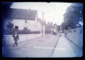
Turning back to my friend’s actual commute, it seems likely that he emerges, bleary-eyed, and cycles out into Brook Street:

Brook Street, Watlington, as taken by Collier

Brook Street, Watlington, early 20th century

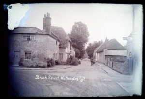
Because I’m uncertain as to where precisely on the modern-day Brook Street we are in this image, here’s another shot which I think may even show the exit from which my friend most likely emerges of a weekday:

Brook Street, Watlington, as taken by Collier

Brook Street, Watlington, early 20th century

I’m sure there are short cuts to be had but as I’m not privy to that fine-grained residential ‘sense of place’ I’m going to guess that from here my friend might turn left into Couching Street, perhaps even using the junction shown in the following photograph (if you look closely you’ll see that its signposted to Lewknor!). However, I suspect he doesn’t travel with a cyclist’s assistant like the distant subject of this image:

Brook Street and Couching Street, Watlington, as taken by Collier

Corner between Brook Street and Couching Street, Watlington, early 20th century

My friend’s commute takes him down Couching Street or in that general direction:

Couching Street, Watlington, as taken by Collier

Couching Street, Watlington, early 20th century

My friend almost certainly passes close to the old town hall and market place. Collier’s work includes two different views of this particular site, which also reveal subjects relevant to the navigational theme sthat I’m exploring here. The first shot features a horse-drawn vehicle:

Town Hall, Watlington, as taken by Collier

Town Hall, Watlington, early 20th century

By comparison, the second shot of this site shows early motor vehicles:

Market Place, Watlington, as taken by Collier

Market Place, Watlington, early 20th century

From here, both Collier and my friend head out into the surrounding countryside. For my friend to have a hilltop perspective like that shown below would entail an inconvenient detour (and possibly more sensible footwear again) but I’ve added this in anyway. It’s not often that the commuters amongst us have the time to take in a vista of our departure point, so I thought he might apppreciate the opportunity, even if the scene appears to be a little hazy as a result of my rushed digitisation:

Watlington from the hills, as taken by Collier

Watlington 'from the hills', early 20th century

My friend is now out into open countryside, cycling along the B4009 to Lewknor in order to make his bus connection. On the way he passes farmland that is representative of the agricultural community surrounding Watlington. An image (MERL P FW PH2/C108/62) in the museum’s Farmers Weekly photograph collection shows combine harvesters traversing a field close to the nearby village of Britwell Salome. This is not on my friend’s direct route but perhaps helps to communicate something of the kind of farming activity one might have seen in this area during the early 1950s.

Back to our route, Pyrton is situated part-way between Watlington and Lewknor, northwest of the B4009. Somewhere beyond it lies Clare Hill, which was almost certainly the location of a place once called Clare Farm. The museum holds farm records related to this site, including a receipt book dating to 1922 and bearing the name of its then proprietor, Charles Hall:

Detail of ledger from Clare Farm, Pyrton

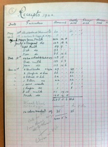
Detail of ledger from Clare Farm, Pyrton, 1922

This set of archival papers also contains details of the sale of this same farm in 1923:

Sale catalogue for Clare Farm, Pyrton

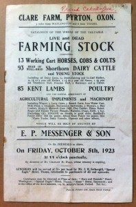
Sale catalogue for Clare Farm, Pyrton, 1923

This is probably enough between Watlington and Lewknor (and I may well have exhausted the museum’s holdings relating to this particular area). Suffice to say, the museum appears to hold significant materials associated with the approximate route so far. From here the road takes my friend onwards between the fields to the centre of another nearby agricultural community at Lewknor. The museum holds an artefact – a musket – that was probably once used by a farmer in this very place:

Accession form for musket

Accession form for musket associated with Lewknor

This brings us to the end of my friend’s cycle ride and the beginning of his coach journey, which follows the motorway from Lewknor all the way to London. I suspect that there are probably numerous artefacts associated with different places situated along the route of the M40. However, my friend will probably have to wait until the project team have worked their data-enhancement magic and we have mapped these holdings in an easy to visualise way!

Lewknor detail on M40 planning map, 1960s

Lewknor on M40 planning map, 1960s

For now lets hope my friend is happy enough to learn of the fascinating papers that the museum holds concerning the impact planning for (and subsequent analysis of) this stretch of motorway, dating to between the 1960s and 1990s. These stem from the rich and detailed archives of the Council for the Protection of Rural England (now the Campaign to Protect Rural England), which include maps showing the intended route as well as papers and correspondence pertaining to the projected impact on the rural area affected:

Wider shot of Lewknor position on M40 map

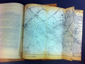
Map showing proposed route (from Lewknor) of the M40, 1960s

Perhaps later in the project I will revisit this exercise to see what further material has come to light in relation to the M40 route. For now though, let me close with the obscure and limited content I managed to find to link to Shepherd’s Bush, which is more or less where my friend’s morning commute comes to an end. The museum catalogue reveals only a single archival item connected in some (unknown) way with this place. This is a drawing from the archive of the engineering company Charles Burrell & Sons Limited, the catalogue entry for which reads ‘Proposed Power House for Rolling Track (Shepherd’s Bush)’. This particular drawing relates to a rival engineeering firm making it even harder to determine what (and indeed where) this machine was intended for. Here is a detail of the drawing, which does not reveal a great deal more than the catalogue entry:

Detail from engineering drawing

Detail from engineering drawing

It is nice to end on an item linked with transport, as well as on something about whcih the museum does not currently know a great deal. If anyone knows more about how this vehicle would have been used please comment. The notion that underpins much of what this project (and indeed this exercise) is seeking to achieve is one of empowering the museum’s ‘source communities’ and harnessing the rich body of knowledge and ideas that the wider public can bring to bear on complex collections like thise held here at MERL.

Now I’m heading off to catch my train…

‘Hefting’ a sense of place – Part 3

In order for us to facilitate connectivity between collections and particular audiences it is vital that we first take steps to find out not only what we have but where it comes from, where it was used, where it was acquired, and any other places it may be in some way associated with. Of course, this may take us far beyond the bounds of England and it will begin to reveal the rich tapestry of local, national, and international relations from which the MERL collections emerged. Nevertheless, much like Roy Brigden’s connection with a new environment, or my own familial links with farming communities of the Scottish Borders, each of us understands place from their own subjective vantage point, wherever and whatever these diverse locales might be. As such, we must be mindful of not only the diversity of our collections but also of the multiplicity of reasons why our audiences may themselves feel hefted to particular places.

A Herdwick sheep

A Herdwick on a Lakeland farm

So, if nothing else these thoughts will hopefully encourage the wider curatorial community to embed place-related data in their catalogues wherever possible, and to capitalise on the potential for new avenues of engagement that might emerge from focussing purposefully on a ‘sense of place’. Through greater acknowledgement of the origins, use-history, and acquisition sources of museum holdings, such collections can be rendered applicable and relevant to particular locations, and re-located (or ‘hefted’) in relation to the modern-day communities within those places and spaces. Equally, for those audiences searching within museum stores or displays for a conceptual hook to render those resources relevant to them as an individual, what better way to maximise their chances of finding such a link than by making explicit the multitude of diverse places associated with the artefacts themselves.