Making computers understand the concept of an ‘object biography’

We’ve gone a bit quiet over recent months on the progress of our work with Historypin, so I thought it was perhaps time for an update on what we’ve been doing behind the scenes.  If you go to the MERL Historypin channel you will be able to see some of the first objects we have pinned to the map.  Most of these are from the Berkshire village of Bucklebury, but there are also some wagons and ploughs from a wider geographic area.

Inevitably, these first trial uploads have thrown up some technical issues that we hadn’t considered.  When we export data from our own Adlib database, we want to minimise the alterations made to that data before it is then uploaded to Historypin.  The fewer changes we make in that intermediate stage, the more manageable and future proof the whole process becomes.

Initially, we had exported our data into a CSV file (it stands for ‘comma separated values’, apparently).  When we looked at the resulting pins on Historypin, we realised the limitations of this approach.  Whilst most of our objects have only one known ‘place made’, ‘place used’ or ‘place acquired’ (if at all), there are some objects for which we have more complete object biographies, where we know perhaps two or three previous owners.  Similarly, there might be a composite object, with multiple parts made by different people.

Fork - 60/290

This fork (60/290) was made in multiple places. Its handle was made by Bucklebury handle-maker Harry Wells, whilst the metal head was made by a local blacksmith.

Because of the way they work (something to do with being ‘comma separated values’) CSV files can only export one occurrence of each database field.  We had to find a new method of exporting which would enable us to pin objects to all the places with which they are associated.  We are currently trialling the use of XML files as an alternative.  We’ve yet to try uploading to Historypin in this way, but our first tests show that we can at least export multiple occurrences using this type of file.  So, we’re making progress.

Another problem we’ve been working through is trying to find a way to export latitude and longitude data for associated places.  Focussing on place has already necessitated the addition of extra fields to the database – initially we recorded latitude and longitude in the notes field of the thesaurus records, but specific fields for grid references have since been added, and we now record the information there.  Due to the way the database works, though, we were initially unable to export the latitude and longitude for places added as ‘associated places’ (rather than as a ‘place made’, ‘place used’ or ‘place acquired’).  This problem has since been solved by extra changes to the databases, but it highlights how projects working with technology such as this require a significant amount of technical work behind the scenes to get museum data online.  It is not always just a case of looking at the accession files and then bunging it all on a computer.

What did you do at work today?… Updated

Things have come a long way since my first blog post back in February about what we do in our work at MERL. No longer do we spend our days solidly cataloguing! In fact, it sometimes feels that a week goes by with hardly any cataloguing at all. So I thought I’d write a bit about some of the other things that we’ve been doing.

JISC Project

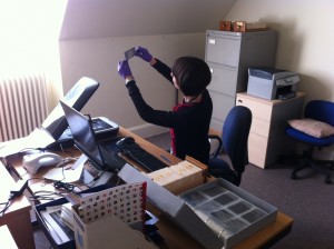
We’re working on a joint digitisation project with University College London, funded by the Joint Information Systems Committee (JISC), as part of Object Based Learning 4 Higher Education (OBL4HE). We’re digitising two things – 60mm negatives of objects in the collection, and documentation relating to 150 selected objects. This involves scanning and some basic editing in Photoshop. Our target is to digitise about 3500 negatives, and we’ve already done 3150, but we’re hoping to carry on and see how far we get – there are 23 boxes of these negatives in the archives, and we’re only on Number 7! We have a wonderful team of volunteers who have done most of the work on the negatives – Felicity and I only spend two or three hours each a week on it. If you’d like to get involved, take a look at our Volunteering page. Felicity and I started scanning the documentation last week and have already scanned 370 documents for 47 objects (there’s often a big chunk of letters and forms in each object file). Have a look at the OBL4HE blog to find out more about.

Me posing for my scanning negatives shot. It's actually quite a relaxing task.

Tour Guiding

MERL offers guided tours to visitors on Wednesday afternoons and weekends, so we’ve taken up the opportunity to be trained as tour guides. As well as practising the general museum tour we’ve also developed a project-focussed ‘Sense of Place’ tour which draws out connections between the displays and the work that we’re doing. We’ve already given our tour twice, but still need a bit more practise.

Felicity posing for her tour guide training shot. Here she's highlighting the regional differences in wagon design.

Bucklebury

As mentioned in earlier posts, we’re working with the Bucklebury History Group on various aspects of the project. Danielle has been enhancing the catalogue records for objects from Bucklebury, concentrating at the moment on the Wells Collection. Harry Wells was a handle maker working in Bucklebury for about forty years until 1950, and we have lots of his tools. I’ve been scanning the Collier Collection of glass plate negatives of Bucklebury. Phillip Osborne Collier was a commercial photographer and postcard publisher working in Reading from 1905. We have around 6000 glass plate negatives of photographs he took in Berkshire, Hampshire and Oxfordshire. The Bucklebury photographs were taken 1905–1960s – they’re beautiful and we’re hoping that the members of the History Group can help us pinpoint more exactly where they were taken. The History Group visited MERL a couple of weeks ago and we’re off to Bucklebury tomorrow for a guided tour to help us get to grips with its geography – there’s  Bucklebury, Upper Bucklebury, Bucklebury Common, Chapel Row, The Slade and numerous other places – and we need to understand how they fit together in order to catalogue them properly. Bucklebury History Group will be at the MERL Village Fete on Saturday 9 June, and Felicity, Danielle and I will be scanning photos of Bucklebury which could be uploaded to Historypin, so do bring any along if you have them. We’ll also be scanning your royal photographs to add to Historypin’s ‘Pinning the Queen’s History‘ page so bring those along too.

General work

We’re also getting to have a go at other curatorial tasks. This includes editing label text for our new exhibition, Our Sporting Life, which runs until 16 September, responding to enquiries, looking into possible acquisitions for the Museum, and supervising visits from researchers and interested groups. Felicity has signed up for various technical training courses as she’s rapidly becoming our technical whizzkid.

And finally…

And finally, we are still doing a bit of cataloguing, although at a considerably reduced rate. Danielle is focussing on Bucklebury objects, Felicity is cataloguing objects from particular cases which can be linked to QR codes and I’m happily cataloguing baskets.