
I was reading the BBC News Magazine online this morning and came across this article about Google street-view, and how, in the author’s opinion, its immersive nature is changing the way we interact with places in a way that paper maps are not able to. It’s an interesting article, and well worth a read, and I feel like I know what the author means. Because I have a dislike of the unknown (and a tendency to over-plan), I sometimes use street-view to ‘practice’ an unfamiliar walking or driving route before I make the actual journey – bringing about a strange sensation of familiarity when visiting places that I have physically never been before.
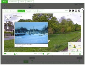
A photograph on the Bucklebury History Group Historypin channel, pinned to street-view.
Primarily though, the article made me think of the work we have been doing with Historypin as part of the A Sense of Place project, as it briefly mentions the fact that the galleries of some Museums are now available to tour on street-view, referring to the Google Maps Art Project. Historypin uses Google Maps as its mapping tool, and users can view some historic photographs pinned in street-view, seeing the old photograph overlaid onto the modern view of the same location. In an earlier post we introduced the tours and collections feature on the MERL and Bucklebury History Group Historypin channels, and one of the nicest features of these is the potential to create a walking tour that a user can follow in street-view, viewing the overlaid historic photographs as they go. I wonder how virtually interacting with places both now and in the past might add another level of complexity to the changing relationship with places that the author of the article claims the technology is fuelling.