By Ray Bell
Wednesday 30th November saw the end of an exceptionally active Atlantic hurricane season. This season produced 19 tropical storms (wind speeds > 38 mph), from which 7 reached hurricane strength (>73 mph) and 3 major hurricane strength (>110mph) (see figure below – or you can watch this animation of the hurricane season produced by NOAA). Most notable storms of the season were Hurricane Irene, which caused an estimated $4.3bn damage and resulted in 40 deaths (iii, 2011) and post-tropical storm Katia made headlines in the UK (BBC, 9th September 2011).

2011 has been the 3rd busiest Atlantic hurricane season tied with 1887, 1995, and 2010, and behind 1933 (21) and 2005 (28). Although the number of tropical storms was much greater than average (11, 1944-2010) the number and intensity of hurricanes was only slightly above average (6). The accumulated cyclone energy (ACE) index – a measure of the strength and duration of storms throughout the season – was 124, slightly above average (101).
Back in May I wrote an article saying what the Met Office and other institutes were predicting for the forthcoming Atlantic hurricane season. This table gives an ensemble forecast, combining all the forecast centres predictions. The Met Office predicted a most likely number of 13 tropical storms (70% range, 10-17) and an ACE index of 151. Overall, the forecast for ACE index was within their range predicted and the number of tropical storms was outside the predicted range. Although the number of tropical storms was outside their range, this is not unexpected as the observed number of tropical storms in a given year is expected to lie within the prediction interval (70%) approximately 7 out of 10 times (Met Office, 2011). Other forecast centres had a similar validation including NOAA and CSU. They all under-predicted tropical storms and over predicted hurricanes partly due to an unusual season.
Atmospheric/Oceanic Conditions
Phil Klotzbach and Bill Gray have produced a fantastic comprehensive document on the physical conditions that were present this season along with the local conditions for each tropical storm. Their summary for the season is as follows:
“The 2011 Atlantic basin hurricane season had activity at above-average levels, but not to the level that was expected in our pre-season forecasts. While anomalously warm tropical Atlantic SSTs and La Niña conditions likely provided conditions that were reasonably favourable for an active season, anomalously cool SSTs in the northeast subtropical Atlantic, anomalously dry mid levels in the tropical Atlantic and a positive Indian Ocean Dipole (IOD) event conspired to put a damper on this season’s more intense tropical cyclone activity. A weakness in the subtropical ridge located near the East Coast helped induce the recurvature of several systems that might otherwise have threatened the U.S. coastline. We have now gone six years since the last major hurricane made U.S. landfall (Wilma – October 2005).”
Dearth of Major hurricane landfalls
Roger Pielke Jr. in his blog was haste to acknowledge the fact that it is now the longest time since records began that the US has gone without a major hurricane landfall – causing headaches for the re-insurance industry. Klotzbach and Gray in their document look into this further and like how the number of tropical storms has huge multi-decadal variability so to does the timing of major hurricanes landfalls.
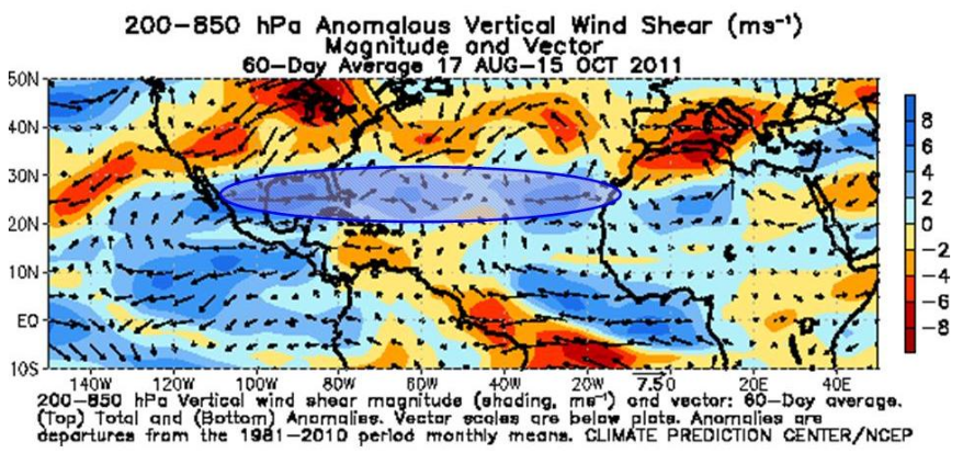
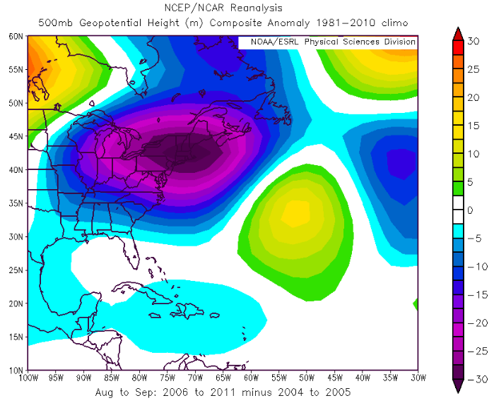
Whether or not a major hurricane makes landfall is governed by mid-level steering currents – a representation of the large scale atmospheric flow. The figure below shows the 500hPa geopotential height anomaly for 2006-2011 minus 2004-2005 (Klotzbach and Gray, 2011). Note the anomalous trough along the US East coast which has kept major hurricanes at bay for the last 6 years.
Short lived tropical storms
None of the first eight storms of the season developed into hurricanes which now means 2011 holds the record for ‘the longest string of tropical storms to start a season without a hurricane on record’. Landsea et al (2010) note there has been a large upswing in the number of weak storms from one per year in early records to 5 per year since 2000 due to improved observational capabilities. It is likely many of the short-lived storms in 2011 may have gone undetected without modern satellite technology (NOAA, 2011).
These short lived storms are hard to detect in the Met Office’s forecasting system. Joanne Camp, a long-range hurricane forecaster at the Met Office says “The forecasting system automatically excludes any short-duration storms to help prevent detection of transient disturbances and depressions”. Joanne then goes on to mention “Hopefully a higher horizontal resolution (planned for the Met Office system summer 2012) will help us distinguish between weak tropical storms and tropical depressions so that unusual season’s (like this year) could be better forecast in the future”. Forecasts for the 2012 season will be available in May.