
By Andrew Gabey
Increasingly detailed weather forecasts will need data from far more weather stations than at present. Filling this gap is especially important for urban areas, where the built environment and the heat emitted by human activities have a complex interaction with the local climate.
Recently there’s been talk of using internet-connected home weather stations (HWS) signed up to the Met Office WOW network to help with forecasting. Greater London alone contains about 1,500 HWS compared with around 10 Met Office and Airport weather stations. So what could HWS data tell us and what are the challenges for researchers in using it?
As an example, here’s a map of air temperature recorded by HWS throughout Greater London on 19 July 2016 (smoothed data from NetAtmo and Weather Underground). This was the hottest day of the year so far with temperatures exceeding 33°C. Blotches on the map reflect HWS locations and a simple calculation fills the space in between. Outlandish readings are filtered out beforehand.
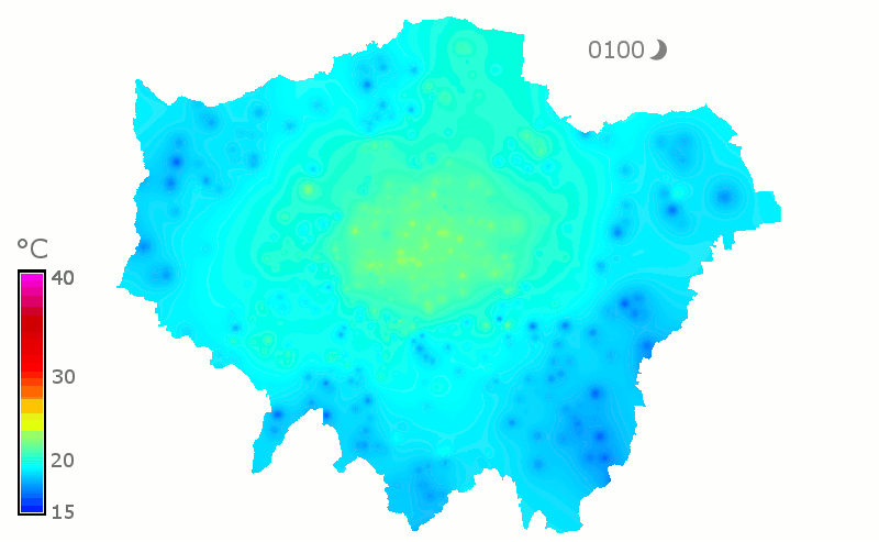
Having so many stations immediately tells us about the structure of heat through the city, which wouldn’t be obvious from using a handful of stations:
- An urban heat island is present (and shrinking) before sunrise. This vanishes once heating gets underway and the wind picks up slightly.

- A slight easterly wind in the evening cools this half of the city, and the heat island is blown off to the south-west.

The big picture and temperatures here are what we’d expect given the city layout and weather conditions, but we need more information before using these numbers confidently in calculations:
- The environment that each station represents: Unlike the networks used here, WOW registration includes a questionnaire for contributors to describe their station’s surroundings.
- The accuracy and bias of each measurement: Do the blotches on the map tell us something scientific, or should they be weeded out?
- How to distinguish a measurement flaw from something surprising but real. Clever methods exist to weed out nonsensical measurements.
Observing stations currently used in forecasting and research are well-understood and maintained regularly, and there’s clearly new information for forecasting and urban meteorology in HWS data. The challenge for researchers is to agree how it complements existing stations, and how to rate the quality of the measurements.