 Did you know that University of Reading Library has more than 70,000 maps and atlases and is one of the largest university collections in the country? Our maps can be used for your teaching, research, and holidays!
Geographical cover
We have excellent coverage of Britain, including detailed coverage of Berkshire and the Reading area. Coverage of Europe is also very good, at least to road map level of most countries.
Coverage of the rest of the world varies with what is available – it may not be possible to obtain recent maps of some areas, especially as many governments consider maps to be politically sensitive. However we will certainly have something for all parts of the globe.
Date range
 Although the collection is mostly post-1900, we have many facsimiles of earlier maps, including reproductions of English 18th century county atlases.
We also have Ordnance Survey maps dating back to 1830, as well as access to Historic Digimap, so it is possible to produce a time sequence of maps of a particular place.
Older versions of atlases and maps may reveal hidden information about a place and its past.
Types of map
 You need to consider the type of map you need, and what you are planning to do with it. Maps come in a variety of different types:
- Sheet maps or atlases
- Flat or folded
- Loanable or reference
- General purpose or thematic
- Paper or digital
Atlases are generally available for loan, and are mostly found in the 912 and FOLIO–912 sequences on the 2nd Floor.
Most of the map collection is non-loan, but a set of folded ‘Field maps’, including British Landranger and geology maps, are available for loan on the 2nd Floor.
Thematic maps show geology, soil types, land use, population, languages – anything which can be shown with a spatial distribution. Many maps of this type are included in atlases, but may also be found as sheet maps.
Digital maps
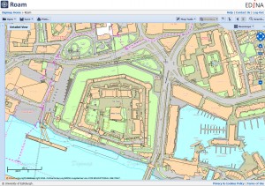
 Digital maps are of increasing importance. For Great Britain, Digimap delivers maps and map data from official sources to UK higher education, and you can easily create authoritative location and site maps. There are five different collections available to members of the University of Reading:
- Digimap – contemporary Ordnance Survey maps and data, ranging from small scale base maps to detailed large scale plans
- Historic Digimap – historic Ordnance Survey maps from 1840 to the 1990s. They can be compared side-by-side to help follow changes in the landscape
- Geology Digimap – geology maps and data from the British Geological Survey (BGS)
- Environment Digimap – landcover maps for different years, from the Centre of Ecology and Hydrology (CEH). This collection includes scans of the Dudley Stamp Land Use maps from the 1930s
- Aerial Digimap – detailed aerial photography in a single seamless coverage, captured since 2000
A simple print out can be produced, or data can be downloaded and used in a Geographical Information System in conjunction with your own data. Look at the GIS & remote sensing section of our LibGuide to find other online sources of digital maps and data.
How to find them
To find paper maps the first step is to search the Enterprise catalogue. Search for the location you want, then refine using the format in the ‘Limit these results’ function to include only maps and atlases (atlases are listed separately – you may need to select ‘more’ to see all the options). Try not to be too specific – a more general search will produce better results.
For more information about searching for maps in Enterprise, and maps in general see the Maps LibGuide.
You can also see our short video presentation, Using maps for your research in University of Reading Library.
Or you can ask the Map Librarian! I am happy to help – email me for an appointment, or find me at the 3rd Floor Information Desk.
This is one of a series of tips to help you save time and effort finding or using information.
This tip was written by Judith Fox, Map Librarian.

