 You’re probably aware that Digimap will provide you with all types of maps and map data of Great Britain. But are you aware that you can also access maps from beyond our shores?
If you need spatial data or maps beyond Great Britain, you can use Global Digimap, part of Edina’s suite of Digimap services. It includes three datasets:

Kenya/Tanzania boundary area. Created using World Panorama data. ©Collins/Bartholomew Ltd. (2019)
- Natural Earth data – small scale open data, created by volunteers, free to use for any purpose
- World Panorama – small scale data created by Collins Bartholomew (publishers of the Times World Atlas)
- OpenStreetMap (OSM) data – crowdsourced open data at various scales. This has world coverage, but the detail varies considerably depending on geographic location. For most urban areas coverage is good, but the more remote a place, the less detail there is likely to be.

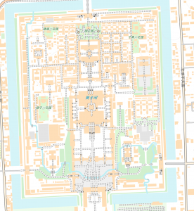
Beijing. Map data ©OpenStreetMap contributors
Two extra data sources are additionally available. When using Roam, they can be accessed through the Overlays button. They are:
- World Place Names – OSM is created by volunteers in the local language, so by adding this overlay to your map you will be given the English version of selected cities and administrative districts.
- WWF World Biomes – This was produced by the WWF to show broad vegetation/ecology groups.
You can also add your own data to Global Digimap by using the WMS Feed option. Search to find suitable feeds, or upload one of your own.
All the usual tools are available as well, so you can measure distance and area, and add your own information by using the drawing tools in the Roam interface.
For more information and support, go to the Digimap Resource Centre and the Digimap YouTube channel.
Judith Fox, Map Librarian

