The Environment Agency is consulting on a new flood alleviation scheme for Reading, to be sited on the banks of the River Thames in Caversham, and they’re inviting local residents to look at the proposals online and give feedback. Reading environmental scientist and Caversham resident Dr Liz Stephens gives her thoughts on the scheme.

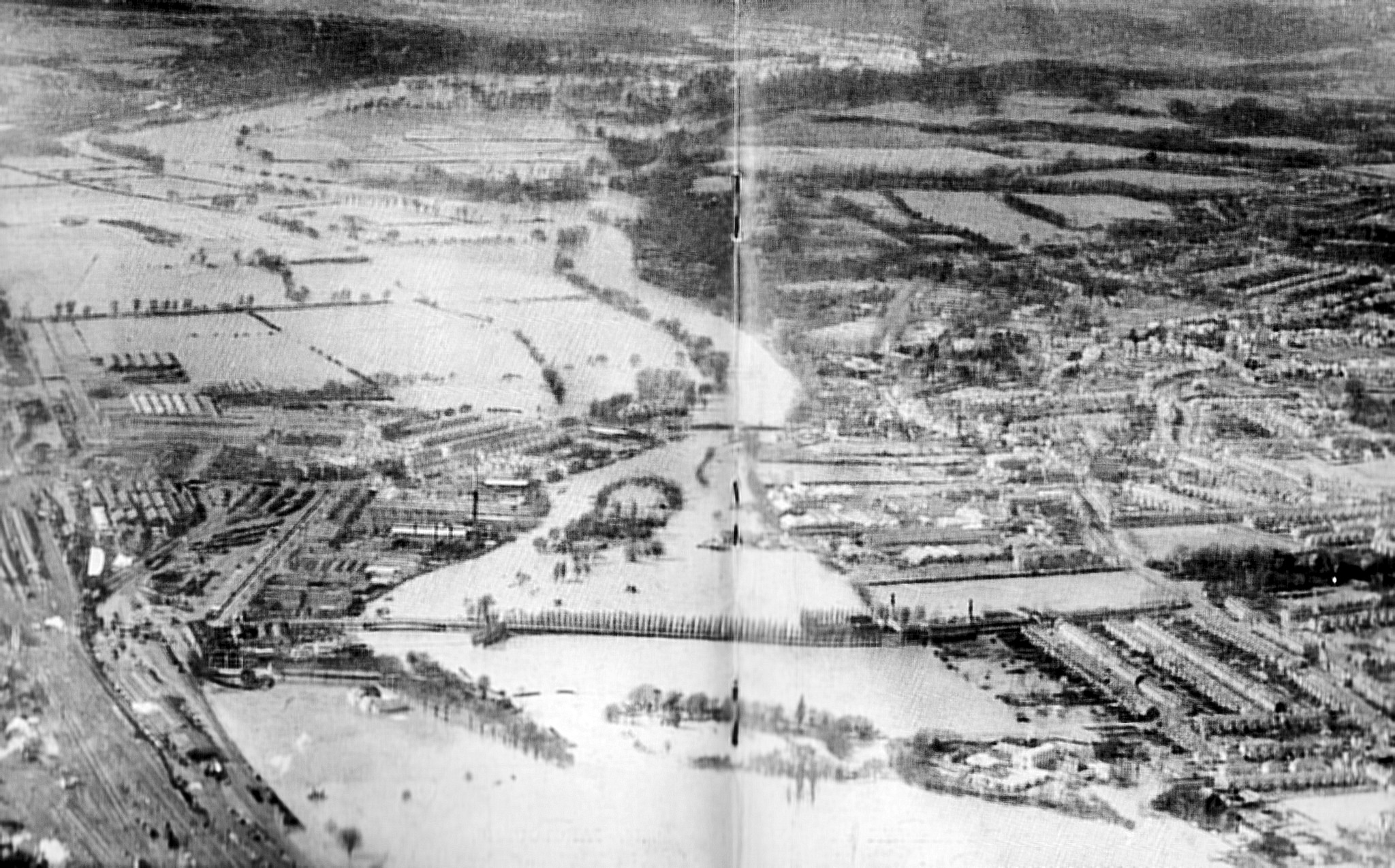
There are plenty of photographs of the 1947 flood in Reading, including this one taken from a plane. Credit: The County Borough of Reading, via Bob Jones
Caversham may have been fortunate to miss out on the worst of the flooding along the Thames in recent memory, but the scale of the flooding experienced in 1947 shows that many people in lower Caversham may unknowingly live in areas at high risk of flooding.
The extraordinary level of the 1947 flood is marked on a pole by Reading Bridge/Whittington’s Tea Barge, which is visible from the Thames Path. It wasn’t a one-off either, as photographs in Reading Museum point to significant flooding in 1894.
Flood risk factors
The Environment Agency uses past river levels (including from 1947) and statistical techniques to calculate the likelihood of different levels of flooding occurring. They also need to take into account that the Thames catchment has changed considerably since 1947; while rapid urbanisation has increased flood risk, better management of locks and weirs, as well as flood schemes such as upstream in Oxford, act to reduce it. On top of that, the possibility that climate change could make things worse in future also needs to be considered.
Hydraulic models take river flows of different sizes and simulate the flow of water over the land to find out which buildings could flood and how deep flood waters will be, from which maps can be created. As a rough guide, if you live for 25 years in a house with an annual risk of flooding of 1%, there is almost a 1 in 4 chance* that your house will be flooded during that time: roughly the same as the chance of flipping two coins and them both coming up heads.
A national solution
The Environment Agency will be looking at solutions to reduce the risk of flooding all along the Thames catchment, and indeed across the whole country. What they are proposing in Caversham is part of this.
Anything built to alleviate the risk of flooding in Caversham will only be permitted if it is proven not to increase the risk of flooding elsewhere. This can be assessed using hydraulic modelling.
A proactive rather than reactive approach is key when improving resilience to floods. We should not just react after a flood hits, but act early on the risk information that hydrological and hydraulic modelling offers. This is why we should commend the EA for addressing the risk in Caversham even though we have not seen extreme floods in Reading for 70 years.
Have your say
The Environment Agency consultation with local residents ensures that local knowledge and opinions are documented and hopefully taken into account. Many people, like myself, who make use of the river environment on a regular basis will be concerned about potential negative visual impact on the area. Having seen the proposals I think they are sensible and sensitive to this. Contrary to suggestions in some news reports, the walls proposed are not between the river and the Thames path, but largely along existing boundaries where walls and fences currently exist.
The public consultation is open online until the end of the month, and the project team will use comments to inform next steps forward and to tweak the design. I’ll be having my say, and I hope that greater awareness of the flood risk we all face will mean my fellow residents will too.
Dr Liz Stephens is a Senior Research Fellow in the University of Reading’s Department of Geography and Environmental Science. Her PhD was in the hydraulic modelling of flooding. She currently works with international partners on the Global Flood Awareness System (GloFAS), which uses statistical techniques to forecast floods and help humanitarian agencies to make best use of these forecasts in deciding when and where to target aid. She is also co-director of Water@Reading, an interdisciplinary research group which generates knowledge on water science and policy.
*Edit made 13/07/18. We originally stated the probability as 1 in 4.

If you live for 25 years in a house with an annual risk of flooding of 1%, the chance that your house will be flooded at least once during that time is NOT 1 in 4, but just under 1 in 4.5
Yes, thanks to the commenter for this. The probability should be calculated as 1 minus the probability of not flooding during that time. The probability of not flooding is (0.01)^25 = 78%. Therefore the probability of flooding during those 25 years in 22% (if you live at the boundary of the 1% flood extent). Most people live within that extent rather than on it, so I’m happy with the coin toss scenario as a tangible analogy!
Thanks Probability – precision in maths always welcome. Well spotted.
The sentence did start ”As a rough guide…” and go on to give the equivalent in coin-flipping terminology. So for the purposes of clarity of understanding, “roughly 1 in 4” arguably carries more meaning than “exactly just under 1 in 4.5”.
Pete Castle