No longer such a new town: Milton Keynes at 50

Plan of Milton Keynes

This year Milton Keynes turns 50.  Tonight BBC4 is marking this anniversary with the programme Milton Keynes and Me by Richard Macer.

Designed to provide housing for over populated London, which had been badly bombed during World War II, development of the existing village of Milton Keynes began in 1967.

Milton Keynes was part of the third wave (1967-70) of new towns, designated following the 1946 New Towns Act, which designated sites to become new towns and passed responsibility for developing them to Development Corporations.  The Milton Keynes Development Corporation was the organisation behind the development of Milton Keynes, Bedfordshire.  The Act followed the Greater London Plan of 1944, prepared by Patrick Abercrombie at the request of the Minister of Town and Country Planning, which laid out plans for how to rebuild London and deliver housing needed for the growing population, following World War II.  Other new towns in England you might be familiar with include Stevenage (1946), Bracknell (1949) and Redditch (1964).

Plan of Milton Keynes from the Milton Keynes Survey

So what does this have to do with English rural life?

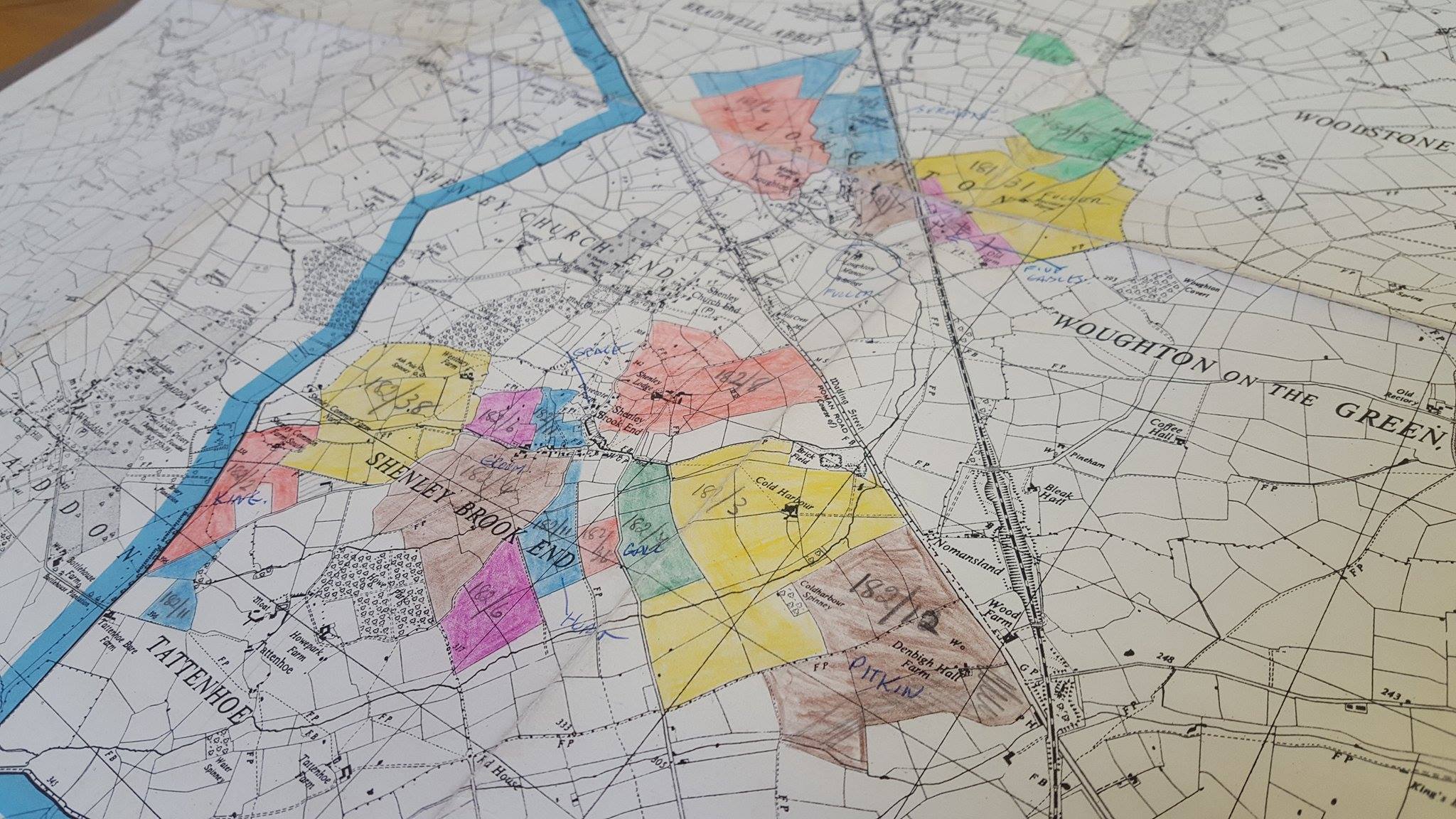
Those new towns needed to be built somewhere.  Often existing settlements were expanded by building on surrounding undeveloped or agricultural land.

The Milton Keynes Survey was conducted by representatives of the Department of Agricultural Economics, at The University of Reading, in the late 1960s to early 1970s.  Files, publications, documents, press cutting and maps relating to the survey are held in the archives of the Museum of English Rural Life (reference: SR DX34).  The material in this collection was compiled by and relates to several studies they published about the impact of Milton Keynes on agriculture in the area.

Our Landscape Institute collections also hold information for researchers of new towns.  We hosted a FOLAR seminar on the topic of new towns and landscape last year.  We hold a copy of The plan for Milton Keynes published by the Milton Keynes Development Corporation in 1970.  The Plan outlines ideas around the transition of land from rural to urban usage and the impact on the environment and landscape the expansion will have.

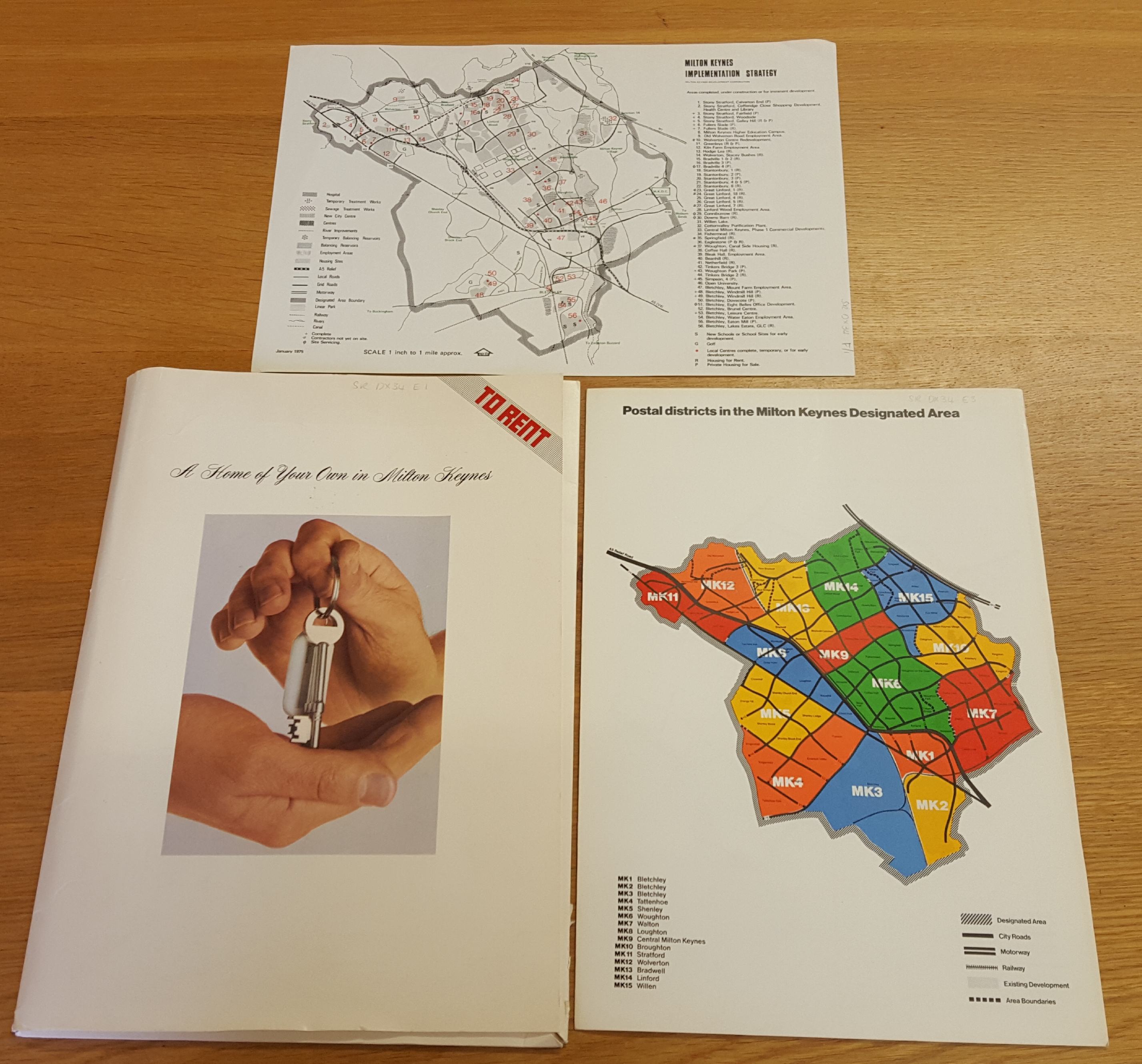
Selection of Milton Keynes material from SR DX 34

When training to be a landscape architect in the late 1970s, Marian Thompson, chose to create a design for a lake in Milton Keynes for one of her exams, named Las Venice.  Though we do not know if the design ever went beyond her exam, the area is now called Tear Drop Lakes and is part of Loughton Valley Park.

Marian Thompson’s plan for Las Venice, Milton Keynes

The development of new towns in the mid to late twentieth century, such as Milton Keynes, brings into sharp focus the reciprocal, but sometimes conflicting relationship between urban areas and the countryside.  How do we balance the need to provide for a growing population with concerns over protecting the landscape and environment?

Claire Wooldridge and Jen Glanville

Project news: Rural images discovered: Colin Shaw

written by Nancy Fulford, Project Archivist.

A couple of weeks ago marked the end of the Rural Images Discovered Project which has seen over 15,000 prints digitised, and many more negatives and prints catalogued from the John Tarlton, Farmers Weekly, Peter Adams and Colin Shaw photographic collections.

1

I came to the Colin Shaw collection towards the end of the project and (in my opinion) we saved the best ‘til last! Colin Shaw has worked as both photographer and lecturer for over thirty years and has recently embarked on a new project looking at the use of the rural myth to promote national parks. His collection contains negatives and prints for two of his photographic projects: Farmwork and M40 Warwickshire.

2

The Farmwork project was undertaken in the mid-1980s. Shaw’s aim was to document the everyday lives of those working the landscape and in doing so dispel the myths of the peaceful rural idyll of the past and show the intensive labour and people needed in modern farming. From potato pickers, to pea swathe operators, a farm worker feeding calves to farmers inspecting hundreds of sheep at market, every black and white picture tells a story of farm workers and modern farming practice. You can see a selection of images on our online gallery.

3

M40 focused on village communities and rural practices and pastimes before and during the construction of the Warwickshire stretch of the M40 motorway in 1988. A family outing rabbit hunting with ferrets, bingo at the village hall and coffin building are just some of the activities documented in this collection.

Having these images now available to view on our online database will help visitors to gain a deeper level of access to our archives whether they are sitting in our Reading Room or at home on their laptop in Australia. They highlight the different stories that can be told by our Archives, and we hope to be bringing more of these stories out in our redevelopment of the Museum.

4


My Favourite Object #4: ‘By the Roadside’ cigarette cards

written by Felicity McWilliams, Project Officer.

Quite a few of my favourite objects in the museum were collected as part of the Collecting 20th Century Rural Cultures project. The project began in 2008, with the aim of acquiring objects for the collections which build a picture of the twentieth century English countryside. A wide variety of objects were collected, such as a Corgi Toy combine harvester, a Farmer Palmer cartoon mug, and suburban railway posters advertising countryside rambles. More so than the rest of the collections, these objects often show ideas and representations of and about the countryside. I’ve chosen object number 2009/69 as my favourite – a full set of 50 Ogden’s cigarette cards, from the 1932 series ‘By the Roadside’. Each card depicts a place of historical or natural interest in or close to a town, with a colour illustration and description of the place on the reverse. The places featured on the cards range from all over England – and two from Scotland. Each illustration also has a small map showing how to find the place in relation to nearby larger towns. As former curator Roy Brigden pointed out in his own blog post about these cards, this implies that the collector could or should take a day trip to visit the featured place. Day trips in the countryside became possible for urban dwellers with the advent of the railways and later the motor car, and other objects in the Collecting 20th Century Rural Cultures collection, such as a 1900’s travelling tea-making basket, point to this popular twentieth century pastime.

2009/69/9: Cigarette card, from the 1932 Ogden’s Series ‘By the Roadside’. This card is ninth in the series of fifty.

2009/69/9: Cigarette card, from the 1932 Ogden’s Series ‘By the Roadside’. This card is ninth in the series of fifty.

Day trips to the countryside are by no means a hobby of the past, either. My own favourite from within this set is the ninth card in the series, which features the wool market in Chipping Campden, Gloucestershire. I like this one in particular because it reminds me of regular and continuing visits to Chipping Campden with my Nan. I’ll admit we probably visit for the tearooms and shoe shop more than the wool market, but it is a fascinating structure that is just part of the great historical interest and beauty of the town.

For me, this set of cigarette cards is very much about the rural landscape and our interactions with it. The Our Country Lives project will tackle the challenge of bringing more stories about rural lives, people, and landscapes into the displays; the objects collected as part of Collecting 20th Century Rural Cultures have a lot of potential to help draw out such themes. The current temporary exhibition at MERL is called Collecting the countryside: 20th century rural cultures, and it features many of the objects collected as part of the project. There’s also a space for visitors to leave their own suggestions and experiences, all of which will feed back into the Our Country Lives redevelopment work.