Professor Richard Bradley nominated for Archaeologist of the Year – vote now!

Richard-Bradley-225x300The Current Archaeology Awards 2017 are open for voting, and for the third year in a row we have a contender in the ‘Archaeologist of the Year’ category – our Emeritus Professor, Richard Bradley!

In the past two years, Professor Roberta Gilchrist (2016) and Professor Mike Fulford (2015) took home the prestigious ‘Archaeologist of the Year’ award.

The award is given based on popular vote, so make sure you click on the link and cast your vote: http://www.archaeology.co.uk/vote

Underwater survey reveals new Neolithic crannogs

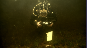
Over the summer, Dr Duncan Garrow spent two weeks carrying out underwater and boat-based survey work on the Isle of Lewis in the Outer Hebrides, in conjunction with his long-term collaborator Dr Fraser Sturt (Southampton) and team. They were investigating potentially the most important new Neolithic sites found in Britain for many years.

IMG_0836

‘Crannogs’ – artificial island settlements constructed in lochs – are a numerous, geographically widespread and intriguing category of archaeological site. Unusually, this one site type was constructed in many different periods of Scotland’s prehistoric and historic past. Most scholars generally consider them to have been built, used and re-used from the Late Bronze Age (c. 1000 BC) to the medieval period (c. AD 1500).


Hugely significantly, our survey of three sites on the Isle of Lewis confirmed that the origins of some of these sites in fact lie 3000 years earlier than previously thought, in the Neolithic (c. 3700 BC). Over 400 crannog sites are recorded in Scotland, and many more no doubt lie undetected. The Outer Hebrides represent a particular hotspot in their distribution, with 150 potential sites identified across the island chain. Mostly unexcavated, it now seems possible that many of these are also in fact Neolithic.

bhorg_survey

This project was only possible due to the curiosity of a local diver and keen archaeologist Chris Murray. Chris noted that a number of small islets in the lochs of Lewis appeared to have causeways going out to them, and to be a very regular shape. To find out more, he took his diving equipment and began to examine the bottom of the loch. The finds he made included a range of spectacular pottery, much of it dating to the Neolithic. He brought these finds to the attention of the archaeological community, with specialists in the museum in Lewis and at the National Museum of Scotland recognising their rare and important nature. It was this point that our joint project was born – we applied for and gained funding from the Honor Frost Foundation.


The newly discovered Lewis sites are extremely impressive – our underwater geophysical survey demonstrated that they are massive piles of rock (c. 15m across and up to 6m high) constructed within what would have been lochs in the Neolithic. Their monumental scale is comparable with local stone-built passage tombs of the same date. Our diver surveys identified worked timbers indicating that the mound structures were revetted; stone causeways out to two of them were also observed. Substantial quantities of pottery and quartz have been found on the loch beds around them. The preservation of ceramics – some vessels complete, many largely intact – is perhaps unique within the British Neolithic.


Since our work in 2016 was non-intrusive survey work rather than excavation, many unanswered questions remain:


– Were these Neolithic crannogs settlements (like their later equivalents) or a new kind of (ritual?) site?

– Does any settlement architecture survive? What buildings and/or other features can be detected?

– What practices were carried out on the islets and how do these relate to the substantial quantities of material recovered from the loch beds nearby?


If these Neolithic artificial islands were settlements, they transform our understanding of social relations at that time – what drove people to isolate themselves from the rest of the community in such a dramatic way shortly after the region was first settled on a substantial scale? Alternatively, if they are specialised, occasional-use sites, what purpose did they fulfil and what roles did they play alongside other monuments? Could they have been meeting/feasting places or venues for other ritual practice, perhaps even including burial?

DCIM100MEDIA

We have applied for further funding in order to undertake small-scale trial excavations on the two most promising sites next summer (2017). Watch this space for further information as more is revealed about these new, exciting discoveries.


If you’d like to find out more about our 2016 survey, it is due to feature on the BBC4 programme ‘Digging for Britain’ to be shown some time this winter (possibly early December last time we were told…).

Finding Nero: Silchester Stories

Fortune favours the bold

As a research and fieldwork active archaeology department, we are extremely fortunate to have one of Britain’s best preserved Roman and Iron Age towns on our doorstep – Silchester, or Calleva of the Atrebates, is less than 10 miles from the Department of Archaeology’s door. The department has been carrying out fieldwork at Silchester, led by Professor Michael Fulford, for nearly 40 years – and this largely undisturbed greenfield site provides many opportunities to pose new research questions, and then to answer them through cutting edge fieldwork.

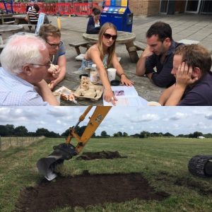
Excavation planning: Step 1 – bring in the machine!

Excavation planning: Step 1 – bring in the machine!

Posing palace questions

For the last 4 summer seasons we have been searching for structural evidence that the Roman Emperor Nero (Emperor from 54 to 68AD) commissioned a palatial residence in the provincial capital of Calleva Atrebatum. Our excavations in Insula IX between 1997 and 2014 had thrown up tantalising evidence for this in the form of high quality building stone incorporated into the foundations of later Roman buildings, as well as pottery tiles stamped with Nero’s name. These tiles are found nowhere else in Britain, and their discovery hints at a high level of imperial involvement – and even investment – into the town. But where exactly was Nero’s palace?

Testing hypotheses

Archaeologists test hypotheses – and ours was that Insula III, centrally located within the town, held the secret – and possibly also the Nero commissioned palace. The Victorians had excavated here in the late 19th and early 20th centuries, and their resultant town plan suggested the presence of a stone founded building of good size. And indeed we thought we might have found it when, in 2013, we began digging in the south-east corner of Insula III and uncovered the colonnaded remains of a mid-1st century AD building, which, at first trowel, looked substantial and significant.

Location, location, location

However 4 seasons of work later, we can unequivocally state that Insula III did not contain a luxurious home to rival those of Rome, and built for a supportive British ruler or noble with Nero’s patronage. Instead we found an unfinished and fairly flimsy structure, built over layers of clay and gravel dumped to offset the soft and slumping fills of the underlying Iron Age pits and wells. It must have been a bitter blow for the builders of Nero’s time to realise that prime building land in the centre of the Roman town, next to the forum, was unsuitable for solid masonry structures. Instead we surmise that the area lay largely unused until the late Roman period when the desire for prime real estate overrode the restrictions of the earlier centuries and allowed the construction of gravel founded timber buildings, jostling for space in this most desirable of town locations.

New knowledge

Archaeology is a voyage of discovery and even if we don’t find what we hoped or expected, there is always a net gain in knowledge. This summer was our last chance to find Nero, and through the use of our – by now – tried and tested methodology of investigating the archaeology of Insula III by simply re-excavating the trenches dug by our antiquarian forbears and using the emptied trenches as ‘key-holes’ into the undisturbed layers, we uncovered a new and detailed sequence from the natural geology through to late or post Roman occupation, followed by 2 phases of Victorian excavation.

Seasons in the sun

We dug for 3 weeks in August and September of this year – and, as it turned out, we had the very best of an English summer: some hot days, lots of bright sunshine, and very little rain. A relatively small research excavation such as this also provides a great opportunity to give employability placement opportunities to our part 2 and Part 3 students, particularly those hoping to enter a career in commercial archaeology. But – to be honest- everyone should add an excavation to their CV – working as part of a team, communicating, solving problems: these are skills all graduates should have on leaving university. Plus, it is enormous fun – working together towards a common research aim, in what can sometimes be challenging physical conditions – what’s not to like?

Caedmon planning

Caedmon planning

 Turf, topsoil and talent

We opened 3 trenches – each with their own objectives – and we had a workforce of up to 20 on site, including a team working with our Finds and Visitors. The stage was set! Step 1 was to get the machining right – using a JCB to strip the turf and topsoil off is a challenging task. Take too much off, and you risk losing vital late and post Roman evidence; take too little off and you are condemning your team to days of backbreaking digging of sterile topsoil deposits and the risk of not finishing on time… With the help of a truly talented digger driver, we got it exactly right, and within a day we could quite clearly see the outlines of the diagonal Victorian trenches as darker stripes cutting through the topsoil and subsoil. Also immediately visible were striations and patterns of gravel which, on cleaning, began to show themselves to be outlines of a late Roman building completely missed by the Victorian excavators whose sole work purpose was to discover large pieces of masonry and exciting artefacts.


Hard at work on a summer’s day

Hard at work on a summer’s day

Antiquarian antics

By the end of the excavation, each trench had a story to tell, and when we left site with a complete record – plans, photographs, samples, finds, record cards – we left behind a very light touch on the archaeology of this major Roman town. We learnt a great deal about the nature of the Victorian intervention, as we tried to second guess their strategies – they do not record exactly how and where they dug – only what they found.

Sifting through the finds in their backfill is equally remarkable in terms of what they threw back in – what they deemed unimportant – or unrecognisable, becomes a treasure trove for us. The antiquarian archaeologists before us gave us no light and shade, no detail of the lives of the people living there. We can now fill in those gaps.

Roman New Build

As with elsewhere in Insula III, we identified substantial clay levelling of a 2nd century AD date, over an uneven surface, and not much construction work until the late Roman period – when a series of gravel-filled foundation trenches were dug to support a large, rectangular building in the north-west corner of the insula. This building had clay and gravel floors (most of which did not survive) and was subdivided into a number of rooms. Associated with it were a sequence of substantial postholes cut into the edge of the gravel surfaced street, dug and re-dug, used and re-used over time, recognising, marking and regularly replacing a boundary. The Victorian excavators of the 1860’s and the 1890’s did not recognise this as a building as such – and so we felt a great sense of achievement when adding it to the known plan of late Roman Silchester. Discovering a previously unknown Roman building is not something you do every day!

Losing Nero

Every excavation has its disappointments – and ours was no exception, We had begun this project in 2013 in the south-east corner of Insula III, looking for a palace of Nero, and we ended in 2016 in the north-west corner knowing that we had not found this building – at least not in Insula III – but knowing that there is enough material evidence to suggest that it is likely to be somewhere within the town. So – no wonderful treasures, no palaces of kings – this time – but we now know what Insula III was all about, and another piece of the jigsaw has been slotted into place. And we had a lot of fun doing so; thanks to a fantastic team!

Team 2016

Team 2016

Amanda Clarke

Landscapes of (Re)conquest: Fieldwork at the castles of Molina de Aragón and Atienza, central Spain, July 2016

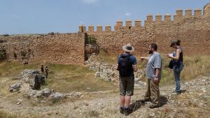
In July, a team consisting of staff and students from the University of Reading (Aleks Pluskowski, Rowena Banerjea, Guillermo García-Contreras Ruiz, Rob Fry, David Thornley (formerly at Reading) and Caedmon Bradley), students from the universities of Granada and Montpellier, spent a week in the province of Guadalajara, central Spain, prospecting and surveying two castles associated with the medieval Christian – Muslim frontier. The project was funded by the Society of Antiquaries and the Erasmus Programme, as pilot studies within the “Landscapes of (Re)conquest project” which is investigating the character of medieval frontiers in South Western Europe. The central part of the Iberian Peninsula represents an exceptional area for investigating the dynamics of frontiers, colonisation and social reorganisation during the formative period of the Middle Ages, when political control of territory fluctuated between Islamic and Christian authorities. Our fieldwork focused on two castles – Molina de Aragón and Atienza – that were linked to medieval frontier authorities during both Islamic and Christian periods of rule. Both sites are defined by the presence of substantial enclosed wards, largely devoid of structures above ground. The use of these spaces and therefore the roles of these fortified sites during the various phases of occupation remain unknown, and the complete lack of palaeoenvironmental investigations has also detached them from their landscape context. The aim of the project was to conduct geophysics surveys within these wards, to obtain environmental data from excavated irrigation channel and terrace within the vicinity of the sites, and to collect samples of building fabric and document phases of construction. This information would be used to characterise how the landscape was used and organised by Islamic and Christian frontier authorities.

20160706_170234

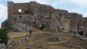
Most of our fieldwork was focused on Molina de Aragón, which consists of a fortified complex, located on a hill overlooking the valley of the River Gallo in the Upper Tagus, one of the principle mountain ranges in Spain and recently designated as a UNESCO Global Geopark due to its unique geological formations. The role of the site changed over time, from a rural fortification during the Islamic period, ruled largely by Berbers (8th–10th centuries), to a focal point for the defence of Al-Andalus against the expansion of Christian kingdoms from the north (10th–11th century) and subsequently the capital of an independent Islamic state, the Taifa of Molina, following the collapse of the Umayyad Caliphate. In 1129, Molina was conquered by King Alfonso I of Aragon. After fierce territorial disputes, it was bequeathed to the Lara family who maintained a virtually independent frontier lordship into the 14th century and developed the associated town. Molina passed to the Kingdom of Aragon for a short period (c. 1366–1375), after which it was incorporated into Castile, and finally into Spain. After functioning as a military barracks throughout the 19th century, the fortress was abandoned from the beginning of the 20th century. Rob Fry and David Thornley conducted magnetometry surveys within the wards of the castle, whilst the rest of the team focused on excavating and sampling an irrigation channel at the edge of the medieval town, taking cores to identify suitable deposits for further environmental sampling and sampling a terrace for OSL dating and geoarchaeological analysis. Environmental sampling was led by Rowena Banerjea with students from Granada and Montpellier. Caedmon Bradley documented the walls of the castle at Molina de Aragón with photogrammetry for his third-year dissertation.

20160706_164424

The second fortified complex included within the project – Atienza – is located within an expansive valley of the mountain range of the Sierra Norte. From the 8th century it was settled and used as a rural fortification by the Berber tribe of Banu Salim. During the Umayyad emirate and caliphate (9th c-10th century), Atienza was an important strategic centre on the border between al-Andalus and the Christian kingdoms. In 1086, the fortress was conquered and became part of Christian Castile. Subsequently, it became the centre of a frontier lordship, securing the border against both neighbouring Muslim territories and the Christian Kingdom of Aragon (11th-12th century). Atienza remained loyal to the kings of Castile in times of internal civil war (13th-14th century), and its prosperity was represented by the construction of fourteen churches, alongside the expanded castle and urban defences. From the 15th century its strategic and economic importance dramatically declined. In the 19th century it was significantly affected by the War of Independence. Here, Rob Fry and David Thornley conducted magnetometer surveys within the castle itself, its outer wards and some of the adjacent parts (now abandoned) of the medieval town. The aim of the surveys was to identify the degree of disturbance and the presence of buried structures where traces of occupation may have been preserved, to inform future excavations.

20160704_131719

The results of these pilot projects are currently being analysed, but they represent an important foundation for more extensive future investigations into the role of these centres of authority in the medieval multicultural frontiers of Iberia.

Get ready for Archaeology at the University of Reading

Want to know more about studying with us? We’ve got a new video up starring some of our undergraduates (and staff!) – check it out!


Gdańsk (Monday 6th June 2016, Alex Miller)

poland1After waking up far too early and sparing way too much time to get to the airport, we were finally in the air and flying over northern Europe. It was a beautiful day and the plane journey took us about 2 hours. As we neared the end and were clearly flying over northern Poland the things that struck me were the vast dark green forests that covered significant portions of the countryside, the many lakes and the small isolated farmsteads. On landing we took a bus through the outskirts of Gdańsk which were littered with Soviet era buildings to the old town where we were staying for the night. We spent the afternoon and evening wondering around the old town. It was surprising to learn (as I am shamefully quite ignorant of modern history) that the majority of the old town had been destroyed by the Red Army at the end of the Second World War and that much of what I was seeing was in fact far newer than I had thought, though it had been reconstructed in the old Hanseatic style. This was both sad, to learn of the destruction, and refreshing to see that it had been rebuilt so well in its original style. The buildings that we saw included warehouses, churches, shops and houses. The houses and shops were particularly beautiful, as they were all painted in different colours and often had friezes detailing particular events in the town’s history, certain merchants or goods that were being sold. Seeing the old town was important because not only did it get me thinking about medieval town layouts and life there in the medieval period, but perhaps more importantly it impressed on me how relevant medieval history still is in Gdańsk, and that they recognise it as part of their heritage, enough to rebuild it in the old style out of the rubble.

Malbork (7th June 2016, Jess Barnsley)

Our first full day in Poland started with a train journey. The train to Malbork took us through some beautiful stretches of rural Poland, and it was a pleasure to see the expanses of greenery and forests from the windows of northern Poland’s new “high speed” trains.

The town of Malbork was as expected, a “soviet style” town with rows of grey, characterless block flats and gridded streets- an unfortunate result of the devastation Poland (then Eastern Prussia) faced during WW2 and the years following.

poland2The ‘bleakness’ of the town was a dramatic contrast to the sight we beheld as we rounded the corner to Malbork’s outer walls and moat. The castle is spectacular. Breathtaking in its sheer size and construction, with the statue of the Virgin Mary proudly reconstructed, the glass mosaic dazzling in the sun.

After quickly unpacking our belongings in the cosy apartments which would be home for the next two days, we met with Zbigniew Sawicki the head of the archaeology department based at Malbork castle. We had a chance to handle some of the castles artefacts; delicate locks and keys, largely intact pottery vessels all the way through to a huge swords found discarded in the moat of the castle.

The castle precinct is vast, and the walk is long, but the views of the castle from the river side were truly spectacular. We were blessed with clear skies and scorching sun, which allowed panoramic views from the tower (well worth the agonizing climb). I couldn’t help but wonder to myself how phenomenal an experience this tower would have been to the men who constructed and worked on it. To see the world from a perspective no other person they knew had reached, in a time before flight, in an area void of mountains, to stand atop this tower would surely have been a life changing experience.

The interior of the castle met with the exterior’s grandeur. The team at Malbork have met the difficult task of preserving and presenting the castle marvellously. There is no way to summarise all of the wonderful features of the castle in just a few words, it really is a sight to behold. The tiled floors, painted arches, vaulted ceilings and not forgetting galleries filled with more amber than one person could need to see in one lifetime are second to none!

Though the day was long and tiring, our time at Malbork castle was far too short. One could spend days roaming the halls and galleries of the building and examining the brickwork fabric of the walls (a habit we had all developed by the time we left Poland!). It is truly one of the greatest medieval sites in the world.

Kwidzyn and Gniew (8th June 2016, Rob Backhouse)

An early morning departure from Malbork saw us taking the train to Kwidzyn, about 25 miles to the south, following the eastern edge of the Forest of Sztum along the escarpment above the Vistula floodplain. We were here to see the unusual conjoined castle and cathedral of Marienwerder, which contained one of the burial sites of the Grand Masters of the Teutonic Order. Our animated local guide showed us a display of three recently discovered burials, taking particular pleasure in the fact that the corresponding crypt at Malbork had produced no extant remains. He was also keen that we see what he called “the largest brick toilet in the world”, which was in fact the latrine tower of the castle and is probably the most striking surviving example of this particular feature of Teutonic Order architecture. The interior of the castle contained an extremely eclectic museum covering everything from modern art to natural history, via a corridor that could have come straight from the Museum of English Rural Life in Reading.poland3

After a quick lunch we made the short trip to the small town of Gniew, with its imposing castle and church dominating the view from the south along the Vistula. From the outside, Mewe Castle is a classic example of the conventual style followed by the Teutonic Order in the late-13th and 14th centuries. Inside, much of the space was given over to a series of displays catering for the large number of visiting school groups (including a dungeon full of the most fiendish torture implements the 19th century mind could imagine), while the sound of children cheering as a 16th century Polish Hussar obliterated watermelons in a variety of creative ways in the grounds outside provided a constant backdrop to our visit. We had seen the continuing resonance of this period of medieval history as we made our way through Gniew’s quaint Old Town earlier in the day, where a modern monument incorporates imagery from the defeat of the Teutonic Order by the Polish-Lithuanian alliance at the Battle of Grunwald in 1410.

A sudden thunderstorm heralded the end of our visit and provided the only break in the otherwise glorious weather we enjoyed during the trip, and we were glad to be able to call a taxi to collect us as the roads back to Kwidzyn began to flood at an alarming rate.

Travelling home (9th June 2016, Alex Pope)

The last day in Poland was devoted to travelling. We caught the train west from Malbork to Gdańsk and, following the compulsory period of English tourist confusion over public transport in another language, we eventually made our way to Lech Wałęsa airport, where we had started our journey three days previously.

Ipoland4t was a wonderful fieldtrip, and we all really valued the opportunity to explore and examine the medieval sites of Poland. They brought our Baltic Crusades module to life, and immeasurably increased our understanding and learning.
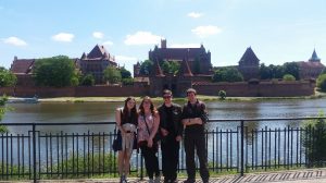
We had an amazing, if occasionally bizarre, time. We visited some fascinating sites, interacted with some brilliant archaeologists, enjoyed beautiful weather and, as is obligatory for travelling archaeologists, sampled the local Polish culture.

Many thanks to Dr Aleks Pluskowski for organising the fieldtrip, and to all the Polish archaeologists and guides who showed us the sites and helped us to understand them. Thanks in particular must go to Zbigniew Sawicki, along with Waldemar Jaszczyński, who took the time to show us the finds from Malbork and gave us an incredible tour of the castle.


Silchester Excavation Project Shortlisted for 2016 British Archaeological Awards

OLYMPUS DIGITAL CAMERA

Judges have today released the shortlist for this year’s British Archaeological Awards showcasing the very latest discoveries and innovations in archaeology across the UK, with Reading University’s long-term Silchester excavation shortlisted for Best Archaeological Project 2016.

The results will be announced at the British Archaeological Awards ceremony at the British Museum in London on 11 July, compèred by ‘Meet the Ancestors’ archaeologist and TV presenter Julian Richards.

John Lewis, Chair of the British Archaeological Awards judging panel for the Best Archaeological Project Award commented on the Silchester project,

The aim of this long-running project is the publication of the total excavation of a large sample (25%) of one insula (block) to characterise the changing nature of the occupation of the Roman town at Silchester. The Judges were impressed with the way the project maximised environmental techniques and the development and use of a sophisticated database to aid analysis and make the findings accessible for future generations. The project has had a long-standing programme of public engagement, with many thousands of visitors each year.

Deborah Williams, Chair of the British Archaeological Awards added,

“The entries this year reflect the incredible wealth and range of archaeology that is going on across the United Kingdom, the quality and expertise of our world-leading archaeologists, and the ever increasing fascination of the public with the history and archaeology of their local area.

“Increasingly archaeologists are responding to this interest by developing new ways to help people to take part in research and excavations, start up their own projects, and share and understand new discoveries – and this shines through in our shortlisted entries. All the finalists have a common theme – involving and enthusing young people and the public in their archaeological heritage.

The British Archaeological Awards entries are judged by independent panels made up of leading experts from across the archaeology field in the UK, including both professional and voluntary sectors and aim to celebrate and share the best of British archaeology with the public.


See the shortlisted projects at www.archaeologicalawards.com and follow the Awards on twitter @BAAWARDSUK

BAA_Logo

Central Zagros Archaeological Project: Excavations at the Early Neolithic Site of Bestansur


Professor Roger Matthews & Dr Wendy Matthews spent their Easter at the early Neolithic site of Bestansur, Iraqi Kurdistan. The excavations at Bestansur are significant as it is such an early settlement, dating to about 7700/7600 BC. At nearly 9000 years old, this provides us with some fantastic evidence for the very first steps of the transition from hunting to farming in the Neolithic period in this region.

The discoveries this season include the careful excavation of a very special building (Building 5) made of lumps of clay with plastered walls & floor, which had an unusual number of human remains interred beneath it. The team have identified a large number of human remains, mostly disarticulated, and often from very small children.

As seen in the video linked to below, one of the theories is that the building may be a special building for the burial of dead people – some of the remains seem to be coming from quite far distances, which is why the bones are disarticulated. With some of the bodies the team also found small offerings, such as beads of clay or stone, including a bead of carnelian which would have had to be imported from Iran or Afghanistan.


About the Excavation

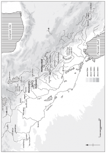
Figure 1. Map to show location of Bestansur and other relevant Neolithic sites of the region.

Map to show location of Bestansur and other relevant Neolithic sites of the region.

A University of Reading and Sulaimaniyah Antiquities Directorate team recently conducted a sixth season of excavations at the Early Neolithic settlement site of Bestansur, Sulaimaniyah Province, Iraqi Kurdistan, between 26 March and 15 April 2016. The team comprised Roger Matthews, Wendy Matthews and Kamal Rasheed Raheem (Co-Directors), Kamal Rauf Aziz and Sami Jamil Hama Rashid (Sulaimaniyah Antiquities Directorate), Amy Richardson (University of Oxford), Sam Walsh (UCLAN), Adam Stone and Tom Moore (University of Reading) and local excavators.  We are very grateful to Sulaimaniyah Directorate of Antiquities for all their support, in particular to the Director, Kamal Rasheed Raheem, the Director of the Museum, Hashim Hama, and our government representatives, Kamal Rauf Aziz and Sami Jamil Hama Rashid, who helped us in many ways and contributed greatly to the success of the season. We are grateful to them all for their hard work all season.

The excavations were financially supported by generous grants from the Gerald Averay Wainwright Fund of the University of Oxford and the British Institute for the Study of Iraq. We are very grateful to these bodies for their kind support.


Excavations at Bestansur, an Early Neolithic settlement

Dr Sam Walsh excavating human remains in Building 5.

Dr Sam Walsh excavating human remains in Building 5.

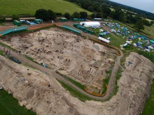
Excavations at Bestansur focused on expansion of Trench 10 to investigate a neighbourhood of Neolithic architecture on the lower eastern slopes of the mound, in an area of 18 x 14m.

This season’s excavations in Trench 10 aimed firstly to investigate and analyse of the human burials below the floors of Space 50 and the stratigraphic context of these, and secondly to define the extent of the building in which they were placed, Building 5, radiocarbon dated to c. 7700 BC.

We established that there are an exceptional number of human remains interred within Space 50. The excavations this season increased the number of individuals identified to more than 55 people, with more remains detected but left preserved in the ground for the next season. This number of individuals is higher than that found in many houses from other Neolithic sites of the Middle East, such as Tell Halula in Syria, for example, where 5-15 individuals were buried within single buildings. The high number within Building 5 at Bestansur is larger than expected for a single household and suggests that there were extensive and long-lived inter-relations between communities.

Four principal groups of human remains were investigated in the south and east of Space 50. All of these represent selective burial of particular skeletal parts,

Cluster of human skulls and other bones buried under room floor

Cluster of human skulls and other bones buried under room floor

predominantly of skulls, long bones and ribs. Two of these groups were of mixed age ranges. One group included red-pigmented material around clusters of bones and another group included traces of white mineral material on many bones and a skull as well as red pigment. A third group comprised predominantly juveniles and infants. The fourth assemblage was represented scattered remains of human bone and beads in the fill below the floors. One unusual bead of carnelian, imported from Iran or Afghanistan, was also found (Fig. 7).

As the walls of Space 50 slope inwards, c. 10 cm of deposits have been left against the base and lower sections of the walls. These microstratigraphic sequences were carefully cleaned with an artist’s palette knife, photographed and drawn at 1:5 and 1:10 to investigate the history of the construction and use of Building 5 and the complex burial sequence throughout the foundation, occupation and infill of the Building.

Carnelian bead from burial deposits under room floor

Carnelian bead from burial deposits under room floor

The north of Building 5, the western narrow rooms and the northwest corner of Space 50 and adjacent buildings were defined by extending trench 10 to the northwest.

We will continue excavation of this extraordinary deposit and building in spring 2017 and beyond.

Recording of human remains was conducted in the field and the laboratory by osteoarchaeologist Dr Sam Walsh (Fig. 4). We are very grateful to the Sulaimaniyah Antiquities Directorate for permission to export human bones and teeth for analysis to study diet, health and mobility. We will be carrying out a full programme of analysis of this very special assemblage of human remains from the Early Neolithic period.


You can watch an interview with Roger on Rudaw TV here

SAGES receives Silver Athena SWAN Award

The School of Archaeology, Geography & Environmental Science has been successful in receiving the Silver Athena SWAN award, given by the Equality Challenge Unit.

Athena SWAN was established in 2005 to encourage and recognise commitment to tackling gender inequality in higher education. It has traditionally covered science, technology, engineering, mathematics and medicine (STEMM) disciplines, but has been expanded to include arts, humanities, social sciences, business and law departments (AHSSBL) as well.

The winning submission from the Gender & Fieldwork photo competition, by George Hibberd

The winning submission from the Gender & Fieldwork photo competition, by George Hibberd

SAGES received the Bronze Athena SWAN Award in 2011 and has continued to be committed to creating an inclusive environment for all. Our School-specific objectives for Athena SWAN are:

1. To aspire to a culture of equality for our staff (academic, admin, research and technical) and students;

2. To enhance induction, communication and consultation processes within and between Archaeology, GES and SAGES;

3. To improve collegiality and achieve a more cohesive structure in SAGES;

4. To foster a supportive culture of mentoring, review (PDRs), training and promotion across SAGES (regardless of career stage).

Dr Nick Branch, current Head of School, says “The last three years has been a period of rapid and positive change for the School. Since our Bronze Award, we have extensively refurbished the School infrastructure, changed the School name and mission, and prioritised equality, diversity and wellbeing. Athena SWAN has been the key platform for transforming the culture and improving working lives within the School.”

Ellie Highwood, Dean for Diversity and Inclusion, said the silver award to SAGES reflected the impact of innovative actions, such as a year-long School-wide “Gender in Fieldwork” project, on everyone in the School.

The Sainsbury Institute Winter Programme: Cultural Exchange & UK Heritage

Our Part 2 Archaeology student, Harry Richardson, recently applied for and was awarded a place on the competitive Sainsbury Institute Winter Programme, accompanying Japanese students to heritage sites around the UK. Read on for more details…


20160219_110455

“The Winter Programme was run jointly by Dr Sam Nixon, a senior research associate of the Sainsbury Institute for Japanese Arts and Culture; and Akira Matsuda, who is doing his PhD in Public Archaeology at the University of Tokyo.

5 Tokyo students were each paired with 5 students from various European universities, including Tübingen, Zurich, York and UEA. Some had an archaeological background, although many were just interested in learning more about the UK. This was done with the intention of promoting an exchange of ideas, in the context of UK heritage which was introduced through a 14-day tour of English cities and archaeological sites. This included (but was not limited to) London, Bath and Norwich.

20160213_132807Each day, we were encouraged to reflect on our experiences and discuss major issues, such as the nature of archaeology and heritage, its relationship with the general public, and how this compares/contrasts with Japan and other countries. This was also done through daily questions, and also through group presentations to help consolidate our ideas. Other events of note included an exclusive tour of the Japan galleries at the British Museum by Nicole Rousmaniere (founder and former SISJAC director) and a final reception at UEA hosted by the Vice Chancellor and Simon Kaner (the current director) that also brought together Japanese students and staff on different programmes at UEA.

I applied to gain an insight into how people from international cultures felt about heritage in Britain, and also to gain knowledge about the issues affecting their countries. The programme largely achieved this, by not only consolidating my knowledge of heritage and the issues that currently affect it, but also through improving my ability to communicate my ideas coherently. Most of all, I enjoyed being received as part of a group who were all inclusive and friendly.

I would definitely recommend this experience to anyone interested in learning more about foreign cultures, improving their communication and language skills, or generally gaining experience for their next career move. UEA also run a Summer Programme, where students gain the opportunity to excavate at an archaeological site in Hokkaido with accommodation included.”


Harry Richardson