 |
By David Flack (University of Reading) 2nd July 2014 |
We are now a month into summer (June, July and August as defined by meteorologists) so convective events (showers, Thunderstorms, etc.) are likely to give us most of our rainfall at this time of year. Convective events provide the most intense, short lived rainfall and often result in flash flooding throughout the world.
My PhD project is part of FRANC and it focuses on looking at the errors in forecasts of these events to see if the forecasts could be improved by assimilating convective-scale data into the forecast. It is of particular interest to see if this data assimilation is of more use in one convective regime compared to the other.
Convection can broadly be classed into two distinct convective regimes: convective quasi-equilibrium or triggered (non-equilibrium) convection. In order to explain these regimes and how they can sometimes lead to flash floods, I need to explain a quantity which gives an indication as to whether convection will occur.
This quantity is the Convective Available Potential Energy (CAPE). It indicates the amount of energy that a parcel of air could have for convective motion, if it is able to get at it.
Consider this sketch of a vertical profile of the atmosphere, with the brown line representing the Temperature, grey line as the dewpoint temperature and red line as a theoretical parcel of air that is ascending through the atmosphere.
If we were to give this parcel of air a kick from the surface it would not rise as it is in stable air, there is an inversion acting as a cap to the motion of a parcel, this is known as the convective inhibition (CIN), the blue area.
If we were to force this parcel of air above this cap and gave it a kick it would rise freely and use the energy (CAPE) as the atmosphere at this point is unstable, and if the parcel is saturated the liquid water vapour would condense and form a convective cloud, that has access to the CAPE and could develop into a thunderstorm. In this diagram the CAPE is represented by the orange area.
There are various different types of convective storms including, showers, squall lines and supercells, to name but a few. Not all of these systems occur in the same dynamical regime and some can occur in both regimes.
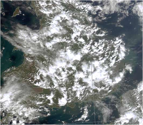
The first regime I shall explain is that of convective quasi-equilibrium. In this type of event the large scale production of CAPE balances its release at the convective scale. This release of CAPE is associated with the rainfall. In this situation the value of CAPE is very small and there is usually no CIN. The weather situation associated with this event is scattered showers. The classic April Showers situation falls under this regime. This type of convection is often associated with a large scale trough in the atmosphere or ascent to the right of a Jet exit (as in the case shown in the satellite image).
Convective quasi-equilibrium can lead to flash flooding from multiple showers passing over the same area in a short space of time, or slow moving cells, with intense convection.
The second regime is that of non-equilibrium (Triggered) convection. In this situation the CAPE is built up over a period of time due to something (CIN) blocking the access to the energy. This can lead to high values (especially in the Great Plains of the USA in spring) of CAPE forming. At some point, if the CIN can be overcome, by large scale lifting or convergence of the winds at the surface (see satellite image below of convection associated with a convergence line on the north coast of Cornwall), the CAPE will be release all at once and this can often lead to explosive convection. This is how severe thunderstorms and supercells occur, or indeed like the flash flooding on 7/8th June (see previous entry). Because there is a distinct trigger it is often known where these events form so with high resolution forecasts there is better forecasting of them.
These events can also lead to flash flooding, by remaining stationary over an area for a period of time, so that one area is subjected to the heavy rainfall, or again by having slow moving cells or rapidly moving cells passing over the same area in quick succession. Indeed the Boscastle event of 2004 was of a similar setup to the satellite image above where the convection did not move from that area. The only reason why this event shown did not lead to a flash flood was that the rainfall was not as intense as Boscastle.
My work has recently involved looking at the separation of these events using a convective adjustment timescale (first proposed as part of James Done’s PhD at Reading in 2002 by one of his supervisors, George Craig, who is one of my supervisors). This quantity gives the time it takes the atmosphere to adjust from an unstable profile to a neutral one (on the diagram showing the CAPE and CIN, the red line would be on top of the brown line for a neutral atmosphere). I have been looking at its sensitivity to various averaging methods and seeing whether or not it could apply to convection over the UK, in order to see if I can use this as a diagnostic for the rest of my work looking into convective-scale error growth. The results so far indicate that the timescale can be used to distinguish between convective regime over the UK and its looks like it will be a useful diagnostic for determining regimes for the rest of my work.


