Promoting the work of ‘A Sense of Place’

Last night Felicity and I actually had an opportunity to share news of the Sense of Place project via an ‘old fashioned’ presentation, as opposed to virtually though our blog and other online media. It’s important to mention here that it was Greta who arranged this talk and had spent time planning it but was unfortunately unable to attend.

We presented a summary of the project and progress made so far to the University of Reading’s Women’s Club.  The Women’s Club was established in 1948 and membership is open to all women who have a connection with the University. The aim of the Club is to provide opportunities for social interaction, with particular emphasis on supporting those who are combining a career and family life and on welcoming newcomers and their families to the University.

They hold various events throughout the year and have a range of interest visiting speakers, talking about a range of topics.

Felicity and I were able to show some examples of the object record files that we have been using to enhance the database with and explain more about how reliant we are on the details which are recorded at the time of acquisition, as well as through research over the years.

We then moved on to demonstrate the applications of our work on Historypin where we have begun to plot some of our collections, alongside photographs.  As previously mentioned, we’ve focused on the area of Bucklebury initially so have therefore been able to make use of the ‘collection’ tool on Historypin, by pulling together some information about George Lailey.  Have a look and you can try it out for yourself!

The talk went well and it was really enjoyable to present our work to a non-museum audience and see that it really is of interest to those who may not be so familiar with accessing this kind of information through the internet and mobile devices.

Apparently, many members of the Club were keen to get online and explore these developments for themselves.  Success!

Making computers understand the concept of an ‘object biography’

We’ve gone a bit quiet over recent months on the progress of our work with Historypin, so I thought it was perhaps time for an update on what we’ve been doing behind the scenes.  If you go to the MERL Historypin channel you will be able to see some of the first objects we have pinned to the map.  Most of these are from the Berkshire village of Bucklebury, but there are also some wagons and ploughs from a wider geographic area.

Inevitably, these first trial uploads have thrown up some technical issues that we hadn’t considered.  When we export data from our own Adlib database, we want to minimise the alterations made to that data before it is then uploaded to Historypin.  The fewer changes we make in that intermediate stage, the more manageable and future proof the whole process becomes.

Initially, we had exported our data into a CSV file (it stands for ‘comma separated values’, apparently).  When we looked at the resulting pins on Historypin, we realised the limitations of this approach.  Whilst most of our objects have only one known ‘place made’, ‘place used’ or ‘place acquired’ (if at all), there are some objects for which we have more complete object biographies, where we know perhaps two or three previous owners.  Similarly, there might be a composite object, with multiple parts made by different people.

Fork - 60/290

This fork (60/290) was made in multiple places. Its handle was made by Bucklebury handle-maker Harry Wells, whilst the metal head was made by a local blacksmith.

Because of the way they work (something to do with being ‘comma separated values’) CSV files can only export one occurrence of each database field.  We had to find a new method of exporting which would enable us to pin objects to all the places with which they are associated.  We are currently trialling the use of XML files as an alternative.  We’ve yet to try uploading to Historypin in this way, but our first tests show that we can at least export multiple occurrences using this type of file.  So, we’re making progress.

Another problem we’ve been working through is trying to find a way to export latitude and longitude data for associated places.  Focussing on place has already necessitated the addition of extra fields to the database – initially we recorded latitude and longitude in the notes field of the thesaurus records, but specific fields for grid references have since been added, and we now record the information there.  Due to the way the database works, though, we were initially unable to export the latitude and longitude for places added as ‘associated places’ (rather than as a ‘place made’, ‘place used’ or ‘place acquired’).  This problem has since been solved by extra changes to the databases, but it highlights how projects working with technology such as this require a significant amount of technical work behind the scenes to get museum data online.  It is not always just a case of looking at the accession files and then bunging it all on a computer.

Places and names

Given that we spend so much of our time looking at places on maps, it is hard not to pay attention to some of the more memorable place names.  There are some gems in the English countryside: places such as Nether Wallop in Hampshire, Wyre Piddle in Worcestershire, and my personal favourite address in Berkshire, Rotten Row, Tutts Clump.  It certainly leads one to think about the origins and etymology of those names.  We notice patterns when cataloguing collections from particular counties; there are lots of places in Sussex with the name component –hurst, and lots in Somerset that include Coombe or Combe.  Incidentally, hurst is a reference to a ‘wooded hill’, and Combe essentially means ‘valley’ (see below for a link to a great website you can search for information like this). 

As I mentioned in a previous post, I have recently spent a lot of time cataloguing ploughs, and one of the most interesting things about the earlier ploughs is that their names often include the name of the county in which they were designed to be used.  Ploughs might be heavy or light for different soil types or the gradient of the landscape.  It is interesting to think that the names of the places in which those ploughs might have been used often reflect those same features of the landscape.  At school in Redditch we were often told that the town was named for the bright red clay that passes for soil in the local area, and like Combe above, many other place names relate to hill and valley features.  As objects often show the links between people and places, so too do the names we call those places.


Gloucestershire Long Plough (54/91)

This is a Gloucestershire Long Plough (54/91), used at Bangrove Farm, Winchcombe. The farmer who used it said that the heavy plough was made to cope with the local clay-like soil, and that he had to hitch five Suffolk punch horses to it to get it going 'full pelt'.

Reading, like many other places, is formed of a personal name and the –ing component – it means ‘the people of Reada’.  Reada, according to an article in The Independent, was ‘an otherwise forgotten man… whose name suggests that he had red hair’.  This feels appropriate, given that I am a redhead myself.  Another somewhat amusing place name etymology is that of Nottingham.  It is formed of a personal name, the ­–ing component, and the –ham component.  In total, it formed Snotta-ingas-ham – the village of Snot’s people.  Nottingham is, all things considered, a rather better name.

It is outside the scope of this project to start recording the origins of the place names we are entering into a hierarchy.  A project which is carrying out this valuable task is the Survey of English Place Names, at the English Place-Name Society and the Institute for Name-Studies at the University of Nottingham (or, the University of the village of Snot’s people).  On their website, you can search a map with information about the origins of English place names.  There is also a wealth of websites and books out there with information about this fascinating area.  For me, it remains an interesting side topic to the main geographical cataloguing I do.  Noticing these sorts of patterns in the names of places in different areas of the country helps me to get an even better appreciation of the significance of place and the landscape for people’s lives, and consequently, the objects in MERL’s collections.

Perhaps there are some other great place names out there that you know about, or places that mean something to you – do comment on this post and share them.  We might even have catalogued an object from there – we can let you know!

6000 Records!

Just another quick message to let you know that this afternoon we reached another milestone total – 6000 records have now been enhanced!  For something nice to look at, too, I’ve added a photo of one of the nicest (and certainly most detailed) pencil sketches I’ve come across whilst working through the catalogue records.


Accession file sketch of a wagon

A pencil sketch of 55/300, a cart used in Hampshire for taking goods to market.

Understanding Bucklebury

Since we’ve gone a bit quiet about our progress on the cataloguing front recently, I thought I would let you know how we’ve been getting on over the past month or so.  We have slowed down somewhat as other aspects of the project start to pick up pace, but our current total sits at just above 4,500 records.  Initially progressing chronologically, we have worked through the records from 1951, when the Museum was founded, to 1954 in full, and have also completed parts of 1955 and 1956.  More recently, though, our focus has shifted to other areas of the collection.  Greta has been working her way through the Museum’s collection of baskets (about which I think she is planning a separate post), whilst Danielle and I have been completing the objects in the collection from the Berkshire village of Bucklebury, in preparation for our work with Historypin.

There are between 300 and 350 objects from Bucklebury in the collection.  It is hard to give a more precise figure, because more information becomes available as we work our way through the records.  We have just one object record file for objects from the Hedges Foundry, for example, but this actually relates to 26 individual wooden patterns.  In addition to the objects from the Hedges Foundry, which was situated in Bucklebury Village, much of the rest of the material comes from the bowl turner George Lailey and the handle maker Harry Wells.

I spoke in a previous post, Cataloguing ‘place’, about our geographical hierarchy, which is largely based on the Getty Thesaurus of Geographic Names, with a few alterations and additions.  In the case of the Bucklebury material, we have decided to add still further levels of detail into our hierarchy.  This reflects the fact that we are in a sense using Bucklebury as a trial area, exploring some of the ways in which this approach can be implemented in collaboration with local communities, and we want to make our hierarchy as relevant as possible to their understanding of ‘place’ in Bucklebury.  Of course, in order to do this, we had to get a good grip on how ‘Bucklebury’ works, which was one of the main reasons for our visit a few weeks ago.

The church gate lantern in Bucklebury Village, made at the Foundry

When we first met the Bucklebury History Group, I naïvely asked ‘So, how exactly is Bucklebury laid out?’  My question was met with knowing smiles.  We had a look at a huge map of the parish, and immediately saw part of the problem, which Danielle also described in her earlier post, The Bucklebury Experience.  Bucklebury Village itself, situated on the banks of the River Pang, is actually quite small.  Upper Bucklebury, where many of the more modern houses are situated, is up to two miles away down narrow country lanes, in the middle of the Common.  A further hamlet, Chapel Row, sits to the eastern edge of the Lower Common.  A smaller hamlet, The Slade, sits on the western edge of the Upper Common.  And then, dotted in between, are other clusters of houses, each with distinct names and identities, but all considered to be a part of ‘Bucklebury’.  These include Turner’s Green, where Lailey’s workshop was situated, Byles Green, Miles’s Green, Workhouse Green, and the grandly named hamlet of ‘Scotland’.

Knowing this, it seemed insufficient to give ‘Bucklebury’ just one listing in the hierarchy.  Besides, the given latitude and longitude on the Getty Thesaurus was situated in a somewhat obscure spot in a field in the parish, which hardly seemed to reflect the complexity of the village’s geography.  Our tour of Bucklebury was incredibly useful.  Physically walking and driving around and between the places in Bucklebury gave us a far better understanding of the place than simply looking at a map.  Obviously this approach is impossible on a larger scale, but for the purposes of our work with the Bucklebury History Group and Historypin, it was invaluable.  The hierarchy we have come up with will hopefully enable the collections to be pinned to the map with as much accuracy as possible, reflecting the level of information we have about places in Bucklebury. 

One of two ancient fish ponds on the Lower Common

The broadest ‘Bucklebury’ thesaurus term in our hierarchy relates to everything within the parish boundary.  At a lower level, we list the larger distinct places: ‘Bucklebury Village [Bucklebury]’, ‘Chapel Row [Bucklebury]’, ‘Bucklebury Common [Bucklebury]’ and ‘Upper Bucklebury [Bucklebury]’.  Some hamlets, such as ‘Bushnells Green [Bucklebury]’ are also listed at this level because they are isolated within the parish, but other hamlets, such as Turner’s Green are first linked to bigger places with which they are associated.  For example, Turner’s Green is situated on the Common, so is listed as ‘Turner’s Green [Bucklebury Common [Bucklebury]]’.  The essence of our approach is to include as much detail as possible, so that we can find the precise latitude and longitude for distinct villages, hamlets, and even houses, which will ultimately enable the collections to be mapped as accurately as possible to the places with which they are associated.  It does feel as though we might have picked the most complicated village in England to use as a case study, but perhaps I am just expecting (or even hoping for) a logical simplicity that simply doesn’t reflect the realities of place.

A good way to end the week

If anyone has been following the progress of our cataloguing, you might like to know that today, we reached another milestone: 4000 records have now been enhanced!  Out of interest, the 4000th record was one of a small collection of materials and tools used in fishing fly tying.  Fly tying is, I must admit, a topic that until about an hour ago, I knew absolutely nothing about.  Whilst cataloguing, we’re learning a lot about the collection, so we’ll continue to blog about certain objects or collections that we each find particularly interesting.  For me, rather inexplicably, this has been wagons and wheelwrighting.  Expect a post in the near future…

Getting from place to place – Part 3

I was pleased to hear from my friend that he had been reading this blog, even proving keen enough to sign up for the RSS feed. As well as coping with the stresses of what can evidently be quite a harrowing commute, this particular friend has a busy work schedule and three young children at home. As such, I am surprised that has found time in his busy life to explore what we are up to. I guess it’s entirely possible that he is just humouring me, or perhaps he browses the web on the coach en route to London! Either way, as a roundabout way of thanking him for taking the time to look, I’ve decided to see if I can chart his commute in some way using artefacts, archival materials, and historic photographs from the museum’s collection. My motivations are not entirely altruistic. This is really an experiment to see if I can find interesting things that connect to and perhaps help to contextualise his route.

Here goes… As I don’t wish to reveal my friend’s precise address, I’ll start with a central feature of his home town Watlington, as depicted by Phillip Osborne Collier (1881-1979), a commercial photographer and postcard publisher who worked in Reading from around 1905 onwards. The Collier collection comprises circa 6000 glass plate negatives of places in Berkshire, Hampshire and Oxfordshire. These were produced between 1905 and the 1960s. Unfortunately, these Collier negatives have not been digitised in their entirety so for ease and rapidity of reproduction here I simply photographed them on a light box and inverted the image using editing software. They are therefore in quite a raw state but will hopefully give you some idea of the places depicted. So, lets imagine that my friend begins his day somewhere near to that central staple of English rural communities, the church:

The church in Watlington, as depicted by Collier

The church in Watlington, early 20th century

This prolific photographer’s glass plate negatives will lead on through the town and into the surrounding countryside. but the church is a nice way to start. My friend lives quite close to it and my family joined his on a visit to see the Christmas tree displays there last December. This provides me with an excuse to add in this Christmas card produced by Collier and featuring scenes from around Watlington:

Christmas card of Watlington, from the Collier collection

Watlington Christmas card, early 20th century

Turning back to my friend’s actual commute, it seems likely that he emerges, bleary-eyed, and cycles out into Brook Street:

Brook Street, Watlington, as taken by Collier

Brook Street, Watlington, early 20th century

Because I’m uncertain as to where precisely on the modern-day Brook Street we are in this image, here’s another shot which I think may even show the exit from which my friend most likely emerges of a weekday:
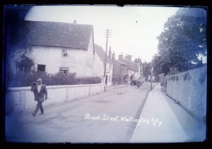
Brook Street, Watlington, as taken by Collier

Brook Street, Watlington, early 20th century

I’m sure there are short cuts to be had but as I’m not privy to that fine-grained residential ‘sense of place’ I’m going to guess that from here my friend might turn left into Couching Street, perhaps even using the junction shown in the following photograph (if you look closely you’ll see that its signposted to Lewknor!). However, I suspect he doesn’t travel with a cyclist’s assistant like the distant subject of this image:
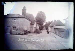
Brook Street and Couching Street, Watlington, as taken by Collier

Corner between Brook Street and Couching Street, Watlington, early 20th century

My friend’s commute takes him down Couching Street or in that general direction:

Couching Street, Watlington, as taken by Collier

Couching Street, Watlington, early 20th century

My friend almost certainly passes close to the old town hall and market place. Collier’s work includes two different views of this particular site, which also reveal subjects relevant to the navigational theme sthat I’m exploring here. The first shot features a horse-drawn vehicle:

Town Hall, Watlington, as taken by Collier

Town Hall, Watlington, early 20th century

By comparison, the second shot of this site shows early motor vehicles:

Market Place, Watlington, as taken by Collier

Market Place, Watlington, early 20th century

From here, both Collier and my friend head out into the surrounding countryside. For my friend to have a hilltop perspective like that shown below would entail an inconvenient detour (and possibly more sensible footwear again) but I’ve added this in anyway. It’s not often that the commuters amongst us have the time to take in a vista of our departure point, so I thought he might apppreciate the opportunity, even if the scene appears to be a little hazy as a result of my rushed digitisation:

Watlington from the hills, as taken by Collier

Watlington 'from the hills', early 20th century

My friend is now out into open countryside, cycling along the B4009 to Lewknor in order to make his bus connection. On the way he passes farmland that is representative of the agricultural community surrounding Watlington. An image (MERL P FW PH2/C108/62) in the museum’s Farmers Weekly photograph collection shows combine harvesters traversing a field close to the nearby village of Britwell Salome. This is not on my friend’s direct route but perhaps helps to communicate something of the kind of farming activity one might have seen in this area during the early 1950s.

Back to our route, Pyrton is situated part-way between Watlington and Lewknor, northwest of the B4009. Somewhere beyond it lies Clare Hill, which was almost certainly the location of a place once called Clare Farm. The museum holds farm records related to this site, including a receipt book dating to 1922 and bearing the name of its then proprietor, Charles Hall:
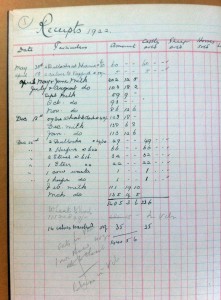
Detail of ledger from Clare Farm, Pyrton

Detail of ledger from Clare Farm, Pyrton, 1922

This set of archival papers also contains details of the sale of this same farm in 1923:
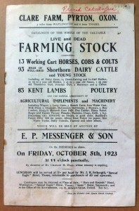
Sale catalogue for Clare Farm, Pyrton

Sale catalogue for Clare Farm, Pyrton, 1923

This is probably enough between Watlington and Lewknor (and I may well have exhausted the museum’s holdings relating to this particular area). Suffice to say, the museum appears to hold significant materials associated with the approximate route so far. From here the road takes my friend onwards between the fields to the centre of another nearby agricultural community at Lewknor. The museum holds an artefact – a musket – that was probably once used by a farmer in this very place:

Accession form for musket

Accession form for musket associated with Lewknor

This brings us to the end of my friend’s cycle ride and the beginning of his coach journey, which follows the motorway from Lewknor all the way to London. I suspect that there are probably numerous artefacts associated with different places situated along the route of the M40. However, my friend will probably have to wait until the project team have worked their data-enhancement magic and we have mapped these holdings in an easy to visualise way!

Lewknor detail on M40 planning map, 1960s

Lewknor on M40 planning map, 1960s

For now lets hope my friend is happy enough to learn of the fascinating papers that the museum holds concerning the impact planning for (and subsequent analysis of) this stretch of motorway, dating to between the 1960s and 1990s. These stem from the rich and detailed archives of the Council for the Protection of Rural England (now the Campaign to Protect Rural England), which include maps showing the intended route as well as papers and correspondence pertaining to the projected impact on the rural area affected:
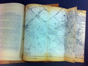
Wider shot of Lewknor position on M40 map

Map showing proposed route (from Lewknor) of the M40, 1960s

Perhaps later in the project I will revisit this exercise to see what further material has come to light in relation to the M40 route. For now though, let me close with the obscure and limited content I managed to find to link to Shepherd’s Bush, which is more or less where my friend’s morning commute comes to an end. The museum catalogue reveals only a single archival item connected in some (unknown) way with this place. This is a drawing from the archive of the engineering company Charles Burrell & Sons Limited, the catalogue entry for which reads ‘Proposed Power House for Rolling Track (Shepherd’s Bush)’. This particular drawing relates to a rival engineeering firm making it even harder to determine what (and indeed where) this machine was intended for. Here is a detail of the drawing, which does not reveal a great deal more than the catalogue entry:

Detail from engineering drawing

Detail from engineering drawing

It is nice to end on an item linked with transport, as well as on something about whcih the museum does not currently know a great deal. If anyone knows more about how this vehicle would have been used please comment. The notion that underpins much of what this project (and indeed this exercise) is seeking to achieve is one of empowering the museum’s ‘source communities’ and harnessing the rich body of knowledge and ideas that the wider public can bring to bear on complex collections like thise held here at MERL.

Now I’m heading off to catch my train…

Cataloguing continues apace!

The project team have just completed their 3000th entry. This is fantastic news. The speed at which they have been working echoes the rapid expansion of the museum in its early years.

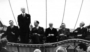
First public opening of the museum, 1955

So many objects and so little space!

Following its establishment in January 1951, the first few years saw expansive growth of the artefact holdings at MERL. Despite modest beginnings the response from object donors and other institutions was huge. By late 1954 the Museum already held over 3500 objects. Its first public displays opened in 1955, by which time the collections had already doubled in size to 7000 items. Perhaps this incredibly rapid expansion meant there was no other space available other than a wagon from which to hold the speeches at the public opening!

The Sense of Place team are currently working on material acquired in the early 1950s during this phase of rapid growth. I hope you will join me in congratulating our Project Officers for such swift, efficient, and effective cataloguing!

Cataloguing ‘place’…

Leaving my own thoughts on what a ‘sense of place’ means to another time, I’m going to talk a little bit about the practical issues we have encountered when putting geographic context about objects onto our database.

Having plenty of geographical context in the paper accession files, we had to decide how to put that information onto the database, and how to make it searchable.  We decided to create a hierarchy of places so that any specific place would, ideally, be linked to a county, region and country. Adlib, the database we’re working with, has a hierarchical capacity which enables us to do this. So, the geographical keyword (i.e. place) ‘Reading’ could be linked to ‘Berkshire’, for example.  This brought up the issue, however, of deciding what form our hierarchy should take.  Should we use a current list of contemporary administrative units, which include ‘unitary authorities’?  Or should we use the still commonly used ceremonial counties?  Long discussions threw up more and more ‘but what if…’ problems.  How would we put ‘the Cotswolds’ into a hierarchy, for example?  What about an object which arrived in the 1950s from Middlesex, a county which completely ceased to exist in the 1960s?

Throughout the course of these discussions, I discovered that my own understanding of the county system in the United Kingdom was woefully inaccurate.  In my defence, it really is quite confusing.  The ‘County of Herefordshire’, for example, is also a unitary authority, and the ‘City of London’ is apparently also a ceremonial county.  Aside from showing up my own lack of geographical understanding though, our discussions did raise an important point – how do our visitors, who will hopefully be using ‘place’ as a way to search and access the collections, understand ‘place’?

Eventually, we decided that the only way to achieve any sort of consistency in our cataloguing was to use a hierarchy based on contemporary administrative boundaries, and we have based ours on the hierarchy used in the online ‘Getty Thesaurus of Geographic Names’.  Bearing in mind some of the ‘problem places’ mentioned above, though, we have added in a number of other hierarchy levels.  These will hopefully enable us to both more accurately represent the level of contextual detail contained in the accession records, and make the hierarchy fit with as many understandings of ‘place’ as possible.

Places are therefore linked first to their ‘administrative unit’, but then also to their ceremonial county (if relevant) and region.  So ‘Reading’ is linked up to ‘Reading [unitary authority]’, which is linked to ‘Berkshire’, which is linked to ‘South East England’, and so on.  A lower level may also be added, that of ‘specific locale’, such as farm names, estate names and, where relevant, street names.  The problem places such as now non-existent counties and vague areas such as the ‘Cotswolds’ are still entered, but link straight to the country/countries they are in.  They are listed as ‘non-preferred terms’, showing that they should only be used when no other information is available, and also have a note which defines the area that they refer to.

It’s certainly not a perfect system, and we still regularly encounter new ‘but what if…’ problems, but we hope that eventually it will enable visitors to access information about ‘place’ in our collections in a way that is both consistent and logical, but also meaningful to them.