Travel Thursday – Frederick de Wit’s Atlas

Written by Fiona Melhuish, UMASCS Librarian

In seventeenth-century Europe, no library would be considered complete without a pair of globes and the provision of up-to-date maps and atlases as a source of information on new discoveries, and at the University of Reading we are lucky to have not only a large map collection at the University Library, but also a number of early maps and atlases.

Perhaps the finest of these is a copy of Frederick de Wit’s Atlas, produced between about 1670 and 1707, and this beautiful volume is the subject of a new Featured Item on the Special Collections website.

Europe

Map of Europe by Frederick de Wit

De Wit was a prolific and skilled map engraver, publisher and seller who became one of the largest publishers in Amsterdam by the end of the seventeenth century. De Wit’s Atlas is one of a series of world atlases compiled by De Wit in numerous editions. Copies of the Atlas are held in a number of map and special collections libraries and private collections, and vary in content from 17 to 190 finely coloured maps.

As with many Dutch maps of the period, the maps in De Wit’s volume feature many elaborate and beautifully coloured decorative features, including illustrations of exotic beasts and even a winged sea monster.

The volume contains a number of maps by De Wit himself, together with maps by other important map-makers of the period including Nicholas Visscher I, Abraham Ortelius and Joan Blaeu, printed by De Wit from plates that he had acquired.

The Atlas is available to view at the Special Collections reading room on request.

Travel Thursday: Thomas Thomson in Sweden

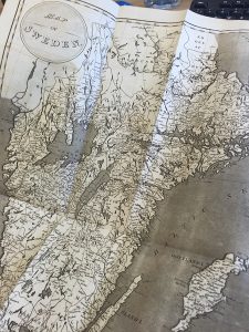
Sweden map smWritten by Louise Cowan, Trainee Liaison Librarian

This week’s Travel Thursday takes us to Sweden with eminent scientist Thomas Thomson.  As the first teacher of practical chemistry in a British university and an elected fellow of the Royal Society of Edinburgh (Morrell, 2004) it is no surprise that much of Thomson’s travelogue has a scientific focus.

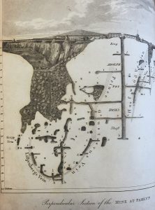
In particular, Thomson devotes a considerable amount of his work to mineralogical observations and detailed descriptions of the mines he visits on his journey.  One such mine is the copper works at Fahlun, one of the oldest in Sweden, which Thomson describes as being 200 fathoms deep and constructed, “according to very scientific and sound principles.”  The maps accompanying his description are wonderfully detailed and were “copied from a very accurate set of charts of this mine, constructed by Baron Hermelin.”  Interestingly, the mine remained open until 1992 and is now a Unesco World Heritage site

Perpendicular section of the copper mine at Fahlun

Perpendicular section of the copper mine at Fahlun

(Falu Gruva, 2014) meaning travellers to Sweden today are still able to tour the mines as Thomson did over one hundred years ago!


Thomson’s scientific interests were also piqued during his time in the Swedish capitol, Stockholm.  In particular, he remarked that the Academy of Sciences, “deserves to be visited by every scientific foreigner who goes to Stockholm.”  It does indeed sound like a fascinating place with an interesting variety of objects. For example, among their collections could be found a piece of bread which in “some parts of Norway and the north of Sweden is made of the bark of trees.”

Elsewhere in Stockholm, Thomson also marvelled at the curious collections in the Arsenal, especially the “the clothes and hat worn by Charles XII when he was shot in the trenches before Frederickshall,” which remained bloodstained from the fatal wounds. He visited most of the churches the city had to offer but did “not consider it as worthwhile to give a particular description of them,” and finally found the perfect spot to view the city – a magnificent bridge joining the central island of Stockholm to the main continent:

When you stand upon this bridge and look south, the King’s palace immediately strikes the eye, a building of immense extent, and seen with peculiar advantage from the bridge.  Toward the east, the inlet of the Baltic stretches itself before the eye covered with ships, and thick scatted with barges plying from place to place under the direction of women; for the boats in Stockholm are all rowed by women.

stockholm map sm

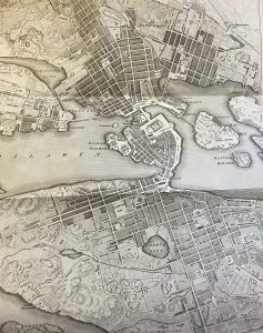
Map of Stockholm, 1812

Again Thomson provides a beautifully detailed map to help illustrate his descriptions.  This map of Stockholm was copied from one published by Fr. Akiel in 1795 and although it had been updated and was considered one of the most accurate maps of the town, Thomson believed, “the style is somewhat blameable, as not sufficiently distinguishing between what is town and what fields.  His object seems to have been to swell the town as much as possible, and conceal its real dimensions from the eye.”  Thomson therefore made several corrections in his own copy.

Overall, Thomson travelled more than 1200 miles in a short seven weeks and though his descriptions of the sights and collections he encounters across Sweden are full of lively detail and interest, it is of course the human stories that provide the colour and character to the narrative; from the wily Olof Essen, a spoke-maker who treated Thomson very ungenerously “with regard to the rate at which he let us have horses from Lilla Oby to Oby;” to the group of English sailors in Stockholm who “had all got quite drunk and had fallen together by the ears, to the number of ten or twelve in the middle of the street, and raised a clamour that was quite diabolical.” Thomson was so mortified by this particular scene that he went so far as to claim:

In most Englishmen who travel, as far as I have had an opportunity of observing them, there is an unaccountable wish to let foreigners, with whom they associate, know that they despise them.

On a lighter note, one of my favourite pieces of the human story in Thomson’s travelogue comes at the end, in an appendix chart showing the population and professions of Sweden:

chocolatemaker

Total number of chocolate makers? One – but he is a master of his art!


Sources:

Thomson, Thomas (1813) Travels in Sweden during the autumn of 1812. London: Robert Baldwin [Overstone 26F/23 – available upon request]

Jack Morrell, ‘Thomson, Thomas (1773–1852)’, Oxford Dictionary of National Biography, Oxford University Press, 2004; online edn, Oct 2006 [http://www.oxforddnb.com.idpproxy.reading.ac.uk/view/article/27325, accessed 6 July 2016]

Falu Gruva (2014) Welcome to Fahlun Mine http://www.falugruva.se/en/

The Edinburgh Imperial Atlas: Ancient and Modern

Written by Louise Cowan, Trainee Liaison Librarian

The Edinburgh Imperial Atlas

The Edinburgh Imperial Atlas


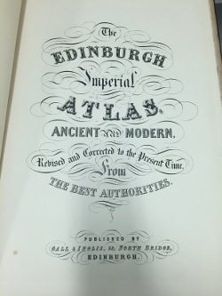
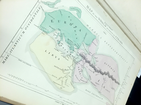
The ‘Edinburgh Imperial Atlas: Ancient and Modern’ (1859) [Overstone – shelf large 34I/10] is a beautiful collection of maps developed from, what the publishers Gall and Inglis describe as, ‘The Best Authorities.’  Unfortunately, very little information is given as to who these authorities may be or which dates the historical maps reflect– indeed only two are named: Gerard Mercator and Strabo.


Strabo (c.64BCE – 21 CE) was a Greek geographer and historian whose work ‘Geography’ diligently describes “the whole range of peoples and countries known to both Greeks and Romans during the reign of Augustus,”(Lasserre.)   Strabo drew on his own travel experiences as well as the first-hand accounts of explorers such as Polybius and Poseidonius, and earlier geographers including, Artemidorus, whose book describing a voyage around the world provided Strabo, “with a description of the coasts and thus of the shape and size of countries,” (Lasserre).

Strabo's Map of the World

Strabo’s Map of the World

Gerard Mercator (1512-1594) was a Flemish cartographer who not only introduced the term ‘atlas’ for a collection of maps but also created “one of the most influential depictions of the globe,” (Molloy, 2015), in 1569, known as the ‘Mercator Projection’.   The map is often still used today; even Google Maps uses a close variant! (Molloy, 2015)

The Mercator Projection

The Mercator Projection

Mercator’s projection was highly useful for sailors and widely used for navigation charts as, “any straight line on a Mercator-projection map is a line of constant true bearing that enables a navigator to plot a straight-line course,” (Britannica.)  However, while the map is an excellent navigational tool, the inaccurate scale of various landmasses make it less helpful as a general map of the world. For example, Greenland is particularly distorted, appearing to be larger in size than South America or Africa. (Molloy, 2015; Britannica)

Although the remaining maps are without their creator’s name tags, they are beautifully rendered and contain a fascinating insight to the historical geography of the time.  I particularly love the details on this map which show the longest rivers and tallest mountains in the Western Hemisphere:

The longest rivers and tallest mountains in the western hemisphere.

The longest rivers and tallest mountains in the western hemisphere.

Based on this newspaper clipping from ‘The Glasgow Herald’ in December 1851, an earlier edition of the ‘Edinburgh Imperial Atlas’ was marketed as an educational resource.  These comparative maps of

The Glasgow Herald -December 1851

The Glasgow Herald -December 1851

ancient and modern geography were first compiled for classroom use by French Jesuit Phillipe Briet in

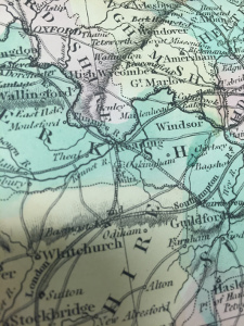
the mid-seventeenth century (Goffart, 2003.)  They usually mirrored the a Ptolemaic prototype, following the ancient map-makers’ focus on showing the outlines of different regions rather than providing glimpses of historical moments, (Goffart, 2003.)  The ‘Edinburgh Imperial Atlas’ is no different with regions being highlighted with beautiful hand-colouring.

Colouring of English counties

Colouring of English counties

A particularly interesting feature of the colouring of this Atlas is the

effect of the pale green colour on the paper.  Below is the reverse side of the map displaying Strabo’s view of the world.  This effect is caused by oxidation of the copper acetate used to create the green pigment

‘verdegris’ (Greek Green) and is usually a sign that the colouring is original and was applied when the map was printed. (Meijer, 2008)

The reverse of Strabo's map

The reverse of Strabo’s map


In his creation of a special collection of ancient maps in the late sixteenth century, cartographer Abraham Ortelius declared,“historiae oculus geographia, “geography (is) the eye of history,”” (Goffart, 2003) and in collections such as the ‘Edinburgh Imperial Atlas’ it is certainly possible to see the historical development of our understanding of the shape of our world.


Sources and Further Reading:

Goffart, Walter. Historical Atlases : The First Three Hundred Years, 1570-1870. Chicago, IL, USA: University of Chicago Press, 2003. ProQuest ebrary. Web. 2 March 2016.

Lasserre François –  Britannica: Strabo

The Glasgow Herald – 22 December 1851

The Edinburgh Imperial Atlas – digitisation

Britannica: Mercator Projection

Molloy, Antonia (2015) Gerardus Mercator: 3 ways influential cartographer changed the way we look at the world 

Meijer,  Boudewijn (2008) Antique Maps – Recognising the difference between old and modern colouring 

Baynton-Williams, Roger., Colouring on Antique Maps

Travel Thursday – Hungary and Transylvania

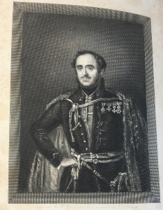
John Paget

John Paget

Written by Louise Cowan, Trainee Liaison Librarian

Born in Leicestershire in 1808, John Paget studied medicine at Edinburgh University before travelling extensively on the continent (Czigány).  His travelogue, ‘Hungary and Transylvania: with remarks on their Condition, Social, Political and Economical’ published in 1839 was formed from his visits to the region during 1835-36 and was illustrated by George Hering, an artist who accompanied him on his journey.

The travelogue provides a plethora of careful insights, humorous accounts and details of historic interest.  It is considered to be of great cultural importance and achieved particular prominence during the Hungarian War of independence in 1848-9 where it was consulted as a reliable source of background information on the country (Czigány).  Indeed, Paget promises in his preface to the work to give an accurate picture of the countries he describes:

I know there are those who think, that “to write up a country,” a traveller should describe everything in its most favourable light; I am not of that opinion, -I do believe that a false impression can ever effect any lasting good.

And there is plenty of evidence that he held to his oath.  He holds nothing back, for example, when describing the poor social behaviour of some guests at a dinner party in Presburg :

a well-polished floor, on which, I am sorry to say, I observed more than one of the guests very unceremoniously expectorate.

Map of Hungary and Transylvania

Map of Hungary and Transylvania

While Paget gives the usual details of landscapes and buildings, he is very much a natural storyteller.  His writing is engaging, imaginative and beautifully descriptive; this passage evokes a sunset over the plains of Puszta–

It is just as the bright orb has disappeared below the level of the horizon; while yet some red tints, like glow-worm traces, mark the pathway he has followed; just when the busy hum of insects is hushed as by a charm…

Although he commended Hering for capturing “whatever might be distinctive, or curious, or beautiful,” on their journey, Paget’s writing is equally captivating – never more so than when he is recounting some of the myths and legends of the

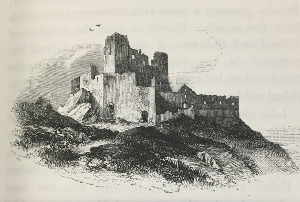
Castle Csejta

Castle Csejta

region (sadly, nothing to do with Vampires).  For example, he recounts a gruesome true story on visiting Castle Csejta; describing the horrendous murders committed by Elizabeth Báthori in 1610.  Believing that bathing in a maiden’s blood would grant her eternal life, “no less than three hundred maidens were sacrificed at the shrine of vanity and superstition” with Elizabeth luring them through a secret passageway from the castle to the cottage of her two accomplices.

Paget’s describes his encounters with the local people with equal animation, honesty and a little bit of sarcastic wit; such as the old man posing for Hering, who, “allowed a limb to be replaced in its former position, when accidentally moved [… ] though he did not seem to have the slightest idea of what was going on,” Or his

Baths of Sliács

Baths of Sliács

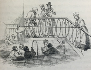
experience at the baths of  Sliács, near Neusohl:

but conceive my horror, precise reader, when some very pretty ladies quietly informed me that they took their second bath in the evening and hoped I would join them!

(And join them he did, once he was properly supplied with an appropriate bathing-dress –  “I do assure you delicate reader, that, as far as I could see, nothing occurred that could shock anyone.”)

Paget later married a Hungarian Baroness, Polyxena Wesselényi, the estranged wife of a Hungarian magnate, Baron László Bánffy, and lived with his family in Transylvania at Gyéres.  He was granted Hungarian citizenship in 1847. Paget became a keen agriculturist and focused his efforts on improving his wife’s estate by applying new agricultural methods and using modern machinery: “A regular visitor to, and adjudicator at, international agricultural fairs, in 1878 he was awarded the Légion d’honneur at the World Exhibition in Paris,” (Czigány).


Sources and Further Reading:

Paget, J. (1839) Hungary and Transylvania. With remarks on their Condition, Social, Political and Economical. London: John Murray. [Available on request – Overstone 27A/13]

Lóránt Czigány, ‘Paget, John (1808–1892)’, Oxford Dictionary of National Biography, Oxford University Press, 2004; online edn, May 2008 [http://www.oxforddnb.com.idpproxy.reading.ac.uk/view/article/21115, accessed 17 Feb 2016]

John Paget Biographies

Diary of John Paget

Travel Thursday – The Voyages of the Alceste

Written by Louise Cowan, Trainee Liaison Librarian

This week’s Travel Thursday follows the voyages of the ship Alceste as recounted by the ship’s surgeon,

Captain Maxwell

Captain Maxwell

John McLeod in his ‘Voyage of His Majesty’s Ship Alceste to China, Corea, and the Island of Lewchew with an account of her shipwreck’ (3rd ed, 1820) [Reserve 915.1].  Under the command of Captain Murray Maxwell, the Alceste was one of the first British vessels to visit Okinawa Island (Lewchew), the largest of the Ryukyu Islands of Japan.

The purpose of the voyage was to transport Ambassador, Lord Amherst to the court of the Chinese Emperor at Peking, in an attempt to open trade with China.  The Alceste sailed in 1816, travelling via Rio de Janeiro and the Cape of Good Hope to China.  Once the Ambassador and his delegation had disembarked, the Captain and crew continued on to explore the region.

Unfortunately, their visits were not always welcomed by the local people, particularly off the West coast of Korea:  “The natives here exhibited, by signs and gestures, the greatest aversion to the landing of a party of ships, making cut throat motions by drawing their

Chart showing the track and discoveries of the Alceste

Chart showing the track and discoveries of the Alceste

hands across their necks and pushing the boats away from the beach.”

It seems as though the Korean people had been forbidden from welcoming strangers to their shores, for when the crew did make land, a chief they had befriended at sea,”clasped his hands in mournful silence; at last bursting into a fit of crying” then seemed to “intimate that in four days […] he should lose his head’’ and refused to welcome them beyond the beach.

They had a more friendly reception on the Island of Lewchew (Okinawa) where, after a cautious introduction, some officers were invited ashore and hospitably entertained, “Many loyal and friendly toasts, applicable to both countries were given and drank with enthusiasm.”

The crew spent several months with the island people, learning about their language, customs and traditions.  McLeod reports for example on the nature of their dance: “The mode of dancing of these people may, strictly speaking, be termed hopping” but the crew did their best to join in forming “a grotesque assembly”.

'Lewchewan' Chief

‘Lewchewan’ Chief

The surgeon also reports on the medical practices of the islanders, noting that when Captain Maxwell injured his finger, the island people were keen to help, sending for one of their surgical professors…“The injury having being examined […] a fowl was killed with much form, and skinned, and a composition of flour and eggs, with some warm ingredients about the consistence of dough, was put around the fractured part, (Which had the effect of retaining it in its position) and the whole enclosed in the skin of the fowl.”

One of the happiest occasions occurred on 25th October when the people came together to celebrate the anniversary of the coronation of George III.  The islanders, “sent on board the ship a great number of coloured paper lanterns, for the purpose of illuminating her at night, in honour of our King.” McLeod states that the day was so remarkable that it would, “often be recalled with delight by all who witnessed the pleasing scene of two people […] harmoniously united in hearty good will and convivial friendship.”

Shortly after, the Alceste left the island and returned to China to collect Lord Amherst, whose delegation had been an unfortunate failure.  From there, the crew’s return journey was fraught with a number of difficulties; not only were they shipwrecked and
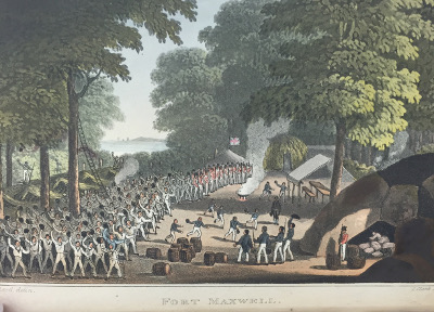
Fort Maxwell - the fort built after the Alceste was shipwrecked, named for her captain.

Fort Maxwell – the fort built after the Alceste was shipwrecked, named for her captain.

attacked by ferocious Malay pirates but their rescue ship, the Caesar, also caught fire!

The voyage home further saw the arrival of two interesting passengers when they made port at Batavia, “a snake of that species called Boa Constrictor; the other an Ourang-Outang.”  McLeod recounts the occasion of them feeding the snake a goat with great fascination, explaining that, “the whole operation of completely gorging the goat occupied about two hours and twenty minutes.”  The ship’s officers also encountered Napoleon Buonaparte at St Helen’s.  Of the French military officer, McLeod states: “Whatever may be his general habit, he can behave himself very prettily if he pleases.”

The crew finally reached home in the autumn of 1817 after a journey of twenty months (Beijing Center).  McLeod published his account of the voyage shortly after his return; a popular work, second and third editions were later released in 1819 and 1820 respectively, (Beijing Center).


Sources:

Beijing Center – Voyage of His Majesty’s Ship Alceste

Office of the Historian – Lew Chew

Naval Military Press

Travel Thursday – Taunt and the Thames

Written by Louise Cowan, Trainee Liaison Librarian.

Taunt on his Boat House

Taunt on his Boat House

This week’s Travel Thursday focuses on adventure a little closer to home, with Henry Taunt’s ‘New Map of the River Thames’ (c.1878)  [Reserve 914.22 TAU]

An Oxford-based photographer, Taunt won great acclaim for the high quality and technical skill displayed in his work, and his photographs, sketches and maps helped to transform, ‘the popularity of the Thames during the Victorian era.’ (In the Boat Shed).

Sometime resident on the river, Taunt could often be spotted ‘in his nautical garb and yachting cap’ (Oxfordshire Blue Plaques) and was known to expertly capture the people and places along the river, providing, ‘an excellent record of late nineteenth and early twentieth century architecture, and town and rural life.’ (National Archives).

Book cover: Taunt's new Map of the Thames

Book cover: Taunt’s new Map of the Thames

Taunt’s ‘New Map of the River Thames’ of which we hold the 5th edition, was described by Taunt as a guide, ‘giving every information required by the tourist, the oarsman and the angler.’ Indeed it contains a wealth of insights into the canals and towns along the Thames during the late nineteenth century, including lock tolls and timetables, charts of distances along the canals, navigation advice, and even tips on preparing a water-tight sheet, (some good duck, boiled linseed oil and strong sewing skills required!)

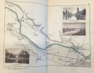
Each place of note along the river is given a carefully sketched map alongside photographs of sites you may see along the way. This sketch of Reading for example, includes photographs of Caversham, Hardwicke House and Mapledurham.

Map of the Thames at Reading.

Map of the Thames at Reading.

The maps are accompanied by a description of some of the main tourist sites in each place. For Reading, Taunt, of course mentions the famous Huntley and Palmers’ biscuit factory, adding that you can pay it a visit, ‘by order obtained on application.’ However, he states that the greatest attractions by far are the Abbey ruins and the Forbury pleasure gardens. Taunt explains their long history and points to the unusual formation ‘of the “Queen’s Head” […] made by the combination of some of the broken walls seen through an opening in them.’ The ruins he declares, ‘form a

charming resting-place if a little time to spare in Reading.’

Father Thames Sketch

Father Thames Sketch

The advertising pages included at the front and back of the book are equally interesting. For example, you could visit ‘Lovejoy’s Library’ apparently the, ‘Largest Provincial Library in the Kingdom’ run by a Miss Langley on London Street in Reading or you could hire a boat from Arthur Henry East at the Kennet’s Mouth if you fancied trying out some of the routes sketched in the guide.

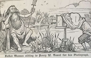
Meanwhile, the adverts at the front of the book boast the talents of Taunt himself, one giving a delightful sketch of his shop on Broad Street, Oxford while another features a fun cartoon of Taunt photographing an anthropomorphised ‘Father Thames’.

As a result of his fantastic survey and mapping of the River Thames, Taunt was elected as a Fellow of the Royal Geographical Society, (Oxfordshire Blue Plaques) and he is credited with sparking, ‘a national love affair with the river that remains to this day,’ (In the Boat Shed).


Sources:

In the Boat Shed

National Archives

Oxfordshire Blue Plaques

Travel Thursday: John Arrowsmith

Written by Louise Cowan, Trainee Liaison Librarian

Born in 1790 in County Durham, John Arrowsmith moved to London at the age of 20 to work under the tutelage of his uncle, Aaron Arrowsmith, a cartographer known for his outstanding accuracy.  Having learned the arts of map making, engraving, and printing, Arrowsmith set up his own business in 1824 and ten years later established his reputation with the ‘London Atlas of Universal Geography’.

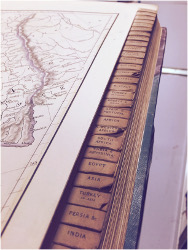
A beautiful tome, hand-coloured and created with original materials, ‘The London Atlas’ was considered to be the best large scale atlas available at that time.  Below is a 1842 edition, which was designed with useful tabbed pages:


London Atlas Photo 25-11-2015, 16 42 18 (1)


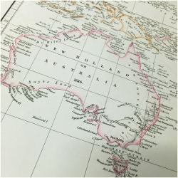
The original atlas consisted of 50 plates of maps but Arrowsmith regularly added to the collection and as such there is no firm collation for any edition.  However, this does mean that the later editions are especially important as they include a greater number of maps, particularly of countries such as Australia.

Map of Australia (1835 edition)

Map of Australia (1835 edition)

Map of Australia (1842 edition)

Map of Australia (1842 edition)


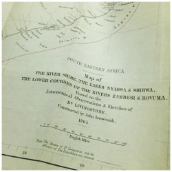
In ‘The London Atlas’ Arrowsmith states that in the creation of the atlas he examined more than ‘ten thousand sheets of printed maps’, gained insights from surveys and also drew on the knowledge of travellers who ‘were particularly acquainted with the districts.’  Indeed, Arrowsmith was friend to a number of explorers and was often responsible for converting their sketched out drawings and surveys into more accurate maps.  This example from Livingstone’s ‘Narrative of the Expedition to the Zambesi’ shows a map created by Arrowsmith in 1865 that was based n the ‘Astronomical observations and skecthes’ of the explorer:

Photo 07-12-2015, 14 37 17

The explorers showed their appreciation of his work by naming after him mountains, plains, and lakes in Australia, New Zealand, and Canada.

(Baigent, 2004)

In 1830, Arrowsmith helped found the Royal Geographical Society and was awarded the society’s Patron Medal in 1862 for his outstanding contributions to the field.


 Sources

Elizabeth Baigent, ‘Arrowsmith, John (1790–1873)’, Oxford Dictionary of National Biography, Oxford University Press, 2004 [http://www.oxforddnb.com/view/article/701, accessed 7 Dec 2015]

Elizabeth Baigent, ‘Arrowsmith, Aaron, the elder (1750–1823)’, Oxford Dictionary of National Biography, Oxford University Press, 2004 [http://www.oxforddnb.com/view/article/698, accessed 7 Dec 2015]

Arrowsmith’s Australian Maps

Crouch Rare Books

Travel Thursday – Thursday’s Child Has Far To Go

Written by Louise Cowan, Trainee Liaison Librarian

On alternate Thursdays for the next few months we will be exploring some of UMASCS collections’ fascinating atlases, maps and travel journals.

To start us off, I present ‘Coxe’s Travels’, a three-volume journal account of ‘Travels into Poland, Russia, Sweden and Denmark.’

Book spine

Coxe’s Travels – Reserve Folio 914.8 COX

The author, William Coxe, a historian and Church of England clergyman, who was born in London on 6 March 1748, travelled frequently during the period of 1775 – 1788. His first trip, with the future eleventh earl of Pembroke, took place from 1775-1779 and formed the basis of this particular travel journal. Coxe is described in the Oxford Dictionary of National Biography as being:

…of medium height, erect and active, and was known for his genial character. In later years he became stout, and his love of good food was well known among his friends.


The books feature beautiful maps of each country, such as this one of Norway, alongside some interesting insights into local culture:

IMG_7213

Wilf, a native of Norway, informs us, that the gentry and inhabitants of the principal towns, allowing for a few provincial expressions, speak purer Danish than is usual even in Denmark, not excepting Copenhagen… – p133

…many of the peasants pretend to be descended from the ancient nobles, and some even from the royal line: they greatly pride themselves upon this supposed descent…  – p134

In his ‘Travels into Poland, Russia, Sweden and Denmark’ Coxe also comments on such diverse things as geographical features, population statistics, royal families, tombs, and chance encounters… one such tale tells of the dangers of travel but also the kindness of strangers:

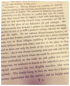
IMG_7214

On September 11 – Having narrowly missed overturning their transport, Coxe and his companion arrive at their destination after midnight to find that the town of Fossum is only a small collection of villages with no obvious place for them to rest. Taking a chance, they knock at the nearest door and are happily received and welcomed by the inspector of the cobalt works nearby:

the gentleman, who had so kindly received us at so undue an hour, and without the least of previous acquaintance, was Mr Bornstein, a native of Germany, lately appointed inspector of the cobalt-works. – p164


Of course, Coxe does not neglect the rare books he finds on his travels, noting, “a most beautiful Cicero’s Rhetoric on Vellum, and a no less beautiful Virgil on vellum, of the eleventh century,” that he finds in the King’s Libraries in Copenhagen.


Volume II and volume III of this 1790 edition of Coxe’s work are located in our Store at Reserve Folio 914.8 COX. A later 5th edition of five volumes is located in our Store at OVERSTONE–SHELF 24E/3 1. Both are available upon request.


Sources:

Knight, Jeremy. “Coxe, William (1748–1828).” Jeremy Knight In Oxford Dictionary of National Biography, edited by H. C. G. Matthew and Brian Harrison. Oxford: OUP, 2004. Online ed., edited by Lawrence Goldman, May 2009. http://www.oxforddnb.com.idpproxy.reading.ac.uk/view/article/6540 (accessed November 5, 2015).