Without meaning to offend anyone with a penchant for cloudy, calm weather with very little temperature fluctuation, I think it’s safe to say that October wasn’t the most interesting of months meteorologically speaking, a fact that was illustrated nicely in WCD today. As a result, I thought I’d take the opportunity to look at a more ‘interesting’ weather event that is expected to develop over the next few days, and that will no doubt affect the UK in some shape or form.
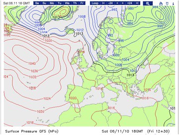
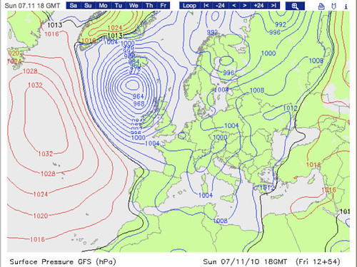
For those who haven’t been spending too much time than is considered cool looking at model runs over the past few days, a fairly standard looking extra-tropical cyclone will be trundling east or northeast towards Greenland, around the edge of a strong (1040mb) anticyclone centred in the western mid-Atlantic tonight and tomorrow. The GFS (Global Forecasting System) model run, initiated at 1200GMT today, predicts intense deepening of this system as it turns sharply southeast and races our way through the course of Saturday night into Sunday, with its central pressure dropping from 992mb to 960mb in the 24 hours between 1800GMT on Saturday 6th and Sunday 7th (two plots of forecast surface pressure are shown below).
This is not a rapidly fluctuating forecast either. Not only is there good agreement between the GFS, ECMWF (European Centre for Medium Range Weather Forecasting) and the UKMO (UK Met Office), but this forecast has been consistent in its general theme for a while now, firming up over the past 36 hours.
The next question is why do I care about the fact that this is happening? For a start, there’s what I mentioned earlier, which is that October was devoid of anything remotely interesting, at least from my point of view. In addition, for as long as I can remember, I can’t think of a case in the recent past (this includes futile attempts at finding papers) that remotely compares to this, especially in terms of the predicted path of the low, coupled with its intensity. The 32mb drop in 24 hours is well ahead of the 24mb in 24 hour threshold for a ‘bomb’ (Sanders and Gyakum, 1980). So why is this happening?
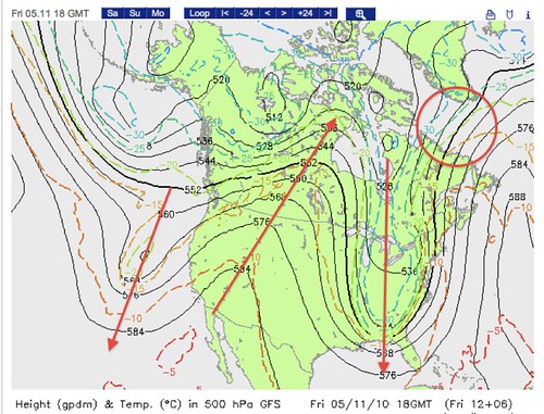
Some of the answer may be found by looking at our friends over the pond right at this very moment (Friday evening in the UK). Taking a look at the chart below a 500mb height and temperature chart, which is again a GFS product. You can see a roughly sinusoidal pattern, with ridges (associated with generally settled weather) and troughs (associated with more unsettled conditions). The ridges (troughs) are marked with upward (downward) pointing arrows. The two pictures are 24 hour apart, the first of which is valid at 1800GMT today, and the second at 1800GMT tomorrow, which is around the time the rapid deepening begins at the surface. Comparing the two circled regions, the height gradient has tightened considerably, which you would associate with strengthening winds in the mid-levels.
In addition, a noticeable shortwave trough (cyclonic kink in the geopotential height field) has developed, and these are marked on the second diagram with downward pointing arrows. This feature helps to strengthen the rising motion through the troposphere, through advection of cyclonic vorticity, and most probably contributes to the rapid deepening of the surface low.
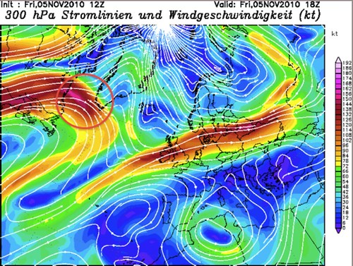
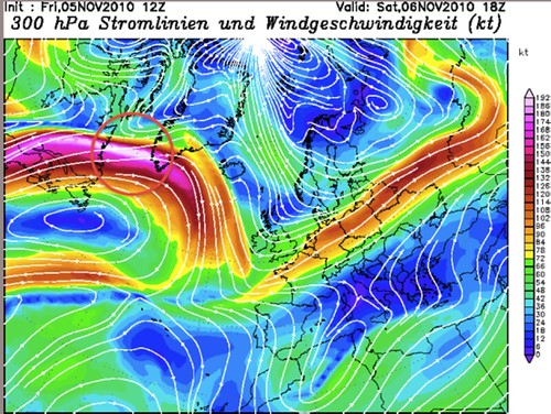
Connected to the mid-level height field is the upper level wind pattern. As mentioned, the mid-level winds strengthened considerably over the 24 hour period. A brief look at the flow pattern slightly higher in the atmosphere, at 300mb, is also useful, over the same time period. Again, the same picture is clear. Prior to the rapid strengthening of the surface low pressure system, upper level winds increased considerably, from around 160 knots (not too shabby) to an eye-watering speed of greater than 192 knots.
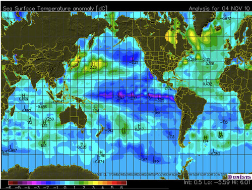
A (fairly) brief look at the surface gives another clue. More specifically, the sea surface. The diagram below in the link below illustrates nicely that anomalously warm water (roughly 3°C above average) is currently lying across the exact area this storm is expected to develop over. This chart is valid for Thursday 4th November, but again, this pattern has changed little in recent weeks.
This relatively warm surface helps with cloud development by increasing low-level convergence, inducing rising motion. As rising air condenses to form water droplets that make up clouds, latent heat is released, which helps to warm the air immediately around it. The extra warming associated with this latent heat release during cloud formation can play a significant role in rapid cyclogenesis cases. In fact, it has been theorised that this condensation heating effect can account for as much as 40 or 50% of the deepening in particularly strong cases (for more information, Reed et al. 1988 is a good source).
A crude way that I thought might help in keeping track of the development of this storm is to look out for how the precipitation forecast associated with the frontal bands changes between now and when the low pressure begins to deepen. More extensive, and heavier, precipitation would be a good proxy for stronger latent heating, since more clouds would be developing in the first place.
To finish, the most rapid deepening is forecast to occur as the system moves south-east out of Greenland, and current indications suggest that it will be filling by the time it reaches our shores, which is either good or bad news depending on whether you’re looking at it from a weather geek’s viewpoint (myself) or a ‘normal’ member of the public, who might be more concerned about the potential for damage to his/her property etc. Throwing it over to anyone else, do people have memories of anything similar to this that approached from such a direction and deepened so rapidly?

It appears the conditions for ‘bombogenesis’ persist until Wednesday, with UKMO calling for another rapid spin-up of a low pressure south of Greenland.