The perennial question of a whether we will have a white Christmas has returned!
In Weather and Climate Discussion, many forecasts have been scrutinised, but exactly how snow forms has not really been discussed. In this article I will answer the following questions:
- how does snow form; and
- will there be a white Christmas this year?
A loose definition of snow: Particles of ice (not ice pellets and hail) formed within a cloud that are large enough to fall to the ground.
Formation
Needless to say, it needs to be cold (T < 273K) for snow to form. Also required for snow formation are water vapour and a mechanism for conversion of this water vapour into ice particles/crystals. In order to form snow, ice nucleation must occur and this requires either an ice nucleus (heterogeneous formation) or temperatures generally below 233K (homogeneous formation). If ice nuclei are present then ice may form within a cloud. Ice has a lower saturated vapour pressure than water and this results in a cloud that was saturated with respect to water being supersaturated with respect to the ice. The result is vapour diffusion onto the ice, and the ice particle will grow at the expense of water droplets – the Bergeron process. However, this method would lead to too few ice crystals for snow and will generally result in “hole punch” clouds – where ice crystals rapidly form around ice nuclei at the expense of liquid cloud water and fall out leaving a hole in the cloud.
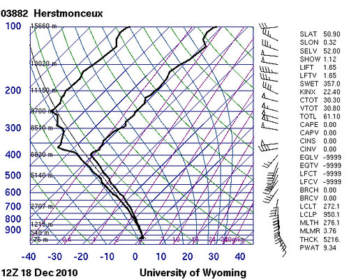
To produce sustained periods of snow fall, homogeneous formation needs to occur. Consider the Herstmonceux sounding at 1200UTC on 18th December 2010 (during the snow fall on Friday):

The ground is below freezing and the top of the cloud (400mb) is a little below -40°C (233K). At the top of the cloud ice is forming homogeneously, grows and then falls through the cloud. As ice falls through the cloud, the particles may grow to form snowflakes through collisions with other snowflakes, vapour diffusion (the Bergeron process) or riming. The presence of ice is demonstrated by the dry bulb and dew point temperature traces being separated by a few degrees Celsius. This is because the vapour pressure over ice is lower than over water, resulting in the air being sub-saturated with respect to water in ice clouds. Near the surface (as the temperature nears freezing) the clouds contain more water and the vapour pressure over ice is nearer that over water – the sounding looks near saturation. Since the sounding is below zero, it is reasonable to conclude that snow would have been falling.
White Christmas
Will there be a white Christmas this year? I am going to approach this question carefully and begin by defining what I mean by a white Christmas. A white Christmas (for this article) is defined as snow lying on the ground at 0900UTC on 25th December 2010. This is not the definition used in betting circles, but would be a Christmas that most people would call ‘white’.
At this time, confidence in the forecast for Christmas is low and this is a brief discussion of a handful of forecasts and not an official forecast!
At the time of writing, the UK Meteorological Office (UKMO) is certainly optimistic that snow will be lying on the ground on Christmas day, with some snowfall:
“UK Outlook for Saturday 25 Dec 2010 to Monday 3 Jan 2011:Continuing cold with further snow, widespread ice, severe overnight frosts and some freezing fog in most parts of the UK for the first few days. Locally significant accumulations of snow can be expected at times. Over parts of southwestern UK it is likely to become less cold and the snow will probably turn to rain at times beyond the Christmas weekend. This unsettled weather with rain, sleet or snow at times is then expected to spread slowly and erratically north and eastwards later next week and into the following week. Probably becoming less cold across much of the UK later in the period, with temperatures returning to nearer normal and precipitation mainly falling as rain. Updated: 1157 on Mon 20 Dec 2010” |
This is for the entire UK and quite general. It suggests that some of the snow in the south may have melted by Christmas day – it is already melting near the coast in Bournemouth. The UKMO currently has no warnings issued for Friday. WeatherOnline states that confidence is low for the Christmas day forecast, but the forecast seems to point to the potential for lying snow for much of the UK except perhaps in the south where sleet or rain may have caused the snow to melt.
The European Centre for Medium Range Weather Forecasts (ECMWF) is predicting a more southerly wind from their deterministic forecast with temperatures below freezing but warm air advection occurring as the day progresses. I cannot access the ensemble forecast plumes and therefore am not be able to comment on the ensemble output.
Conclusion: There is a lot of uncertainty regarding the Christmas day forecast at this time, however current forecasts seem to point towards a cold day with the potential for lying snow. Only time will tell whether the forecasts verify or not, but at least some of us may well see snow on the ground on Christmas day.