In many summers, a normal monsoon is forecast by the India Meteorological Department using their statistical model. 2012 was no different, and in the absence of large external drivers such as ENSO or anomalous snow cover over the Himalaya, the IMD early-stage forecast issued in April (model described here) suggesting that the chance of getting rainfall within 96-104% of the long period average (LPA) was 47%.
The onset of this year’s monsoon took place on 5 June, a short while beyond the forecast of 1 June but well within the normal range. Incredibly the onset as defined over the south-western Indian state of Kerala has a standard deviation of only 7-8 days, giving a clue to how strongly tied to the timing of the monsoon are the lives and work of the Indian population. The onset progresses in a north-westward direction to cover almost the whole country in monsoon rainfall by mid-July near the border with Pakistan.
In mid to late June the monsoon underwent a stall or hiatus, not advancing north of mid-Maharashtra between 6 and 16 June (see Figure 1), causing problems for agriculture.
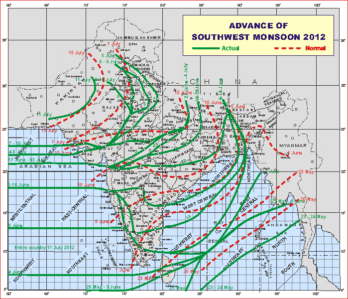
Figure 1: 2012 monsoon onset progression (green curves) and normal dates (red curves). Source: India Meteorological Department.
A further delay in advancing over the north of the country in late June led to widespread fears of drought after a very normal monsoon in 2011 should the poor rains continue.
The delay in the monsoon onset in mid- and late-June is reflected in Figure 2, which shows the daily rainfall totals averaged across the whole country. These breaks are part of the intraseasonal variability of the monsoon and are subject to considerable present research owing to their effects on agriculture (for example, the extended break in July 2002 in which the country received only 50% of its normal rainfall, even causing a drop in India’s GDP. From here on in, the monsoon looked like it was never going to recover.
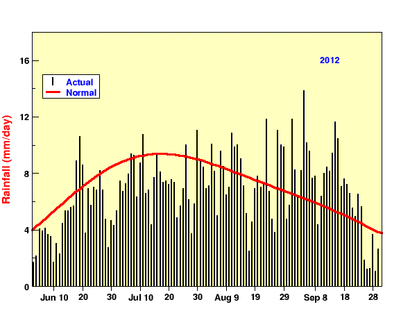
Figure 2: Monsoon On-Line’s daily rainfall totals for India. Source: Indian Institute of Tropical Meteorology.
Fortunately, the IMD update their monsoon forecast from late June, when further information on the tendencies of spring-to-summer SSTs in the Pacific Ocean are available. Dynamical forecasts of ENSO conditions being made at that time were for neutral to weak El Nino conditions (see Figure 3), however the emergence of even weak El Nino conditions in the central rather than east Pacific can cause quite large deficits in the monsoon (e.g., in 2002, 2004 and 2009).
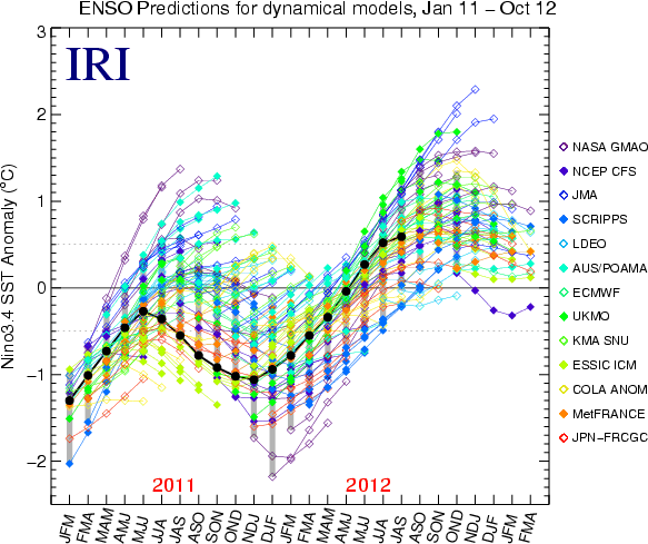
Figure 3: Summary of IRI’s dynamical model ENSO forecasts for the last 22 months. Individual models are shown by the colours and observations are in black. Source: The International Research Institute for Science and Society.
However, conditions are currently neutral in the equatorial Pacific, with temperatures having cooled recently in the central region.
Quite a severe drought looked likely until September, and it wasn’t until 8 September that the accumulated rainfall total came back within normal limits (above the -1 standard deviation line, representing 90% of LPA rainfall) as in Figure 4.
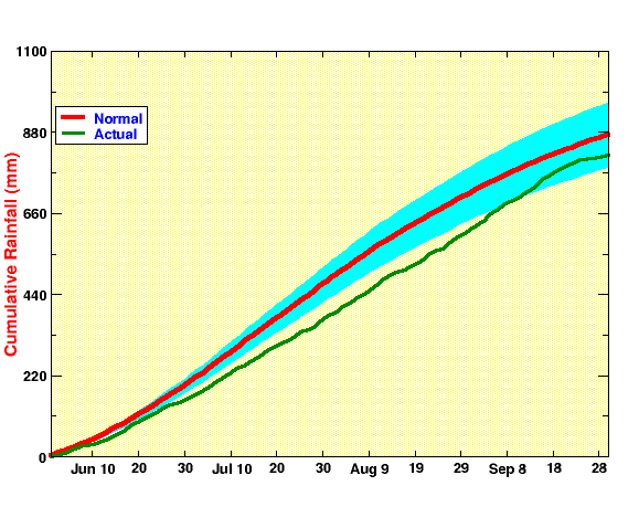
Figure 4: Monsoon On-Line’s cumulative daily rainfall totals for India. Source: Indian Institute of Tropical Meteorology.
The late surge in rainfall was aided by the eastward passage of the Madden-Julian Oscillation (MJO) along the equator in late August and early September seen by the blue contours near 80E in Figure 5, as its active phase brought enhanced convection to Indian longitudes.
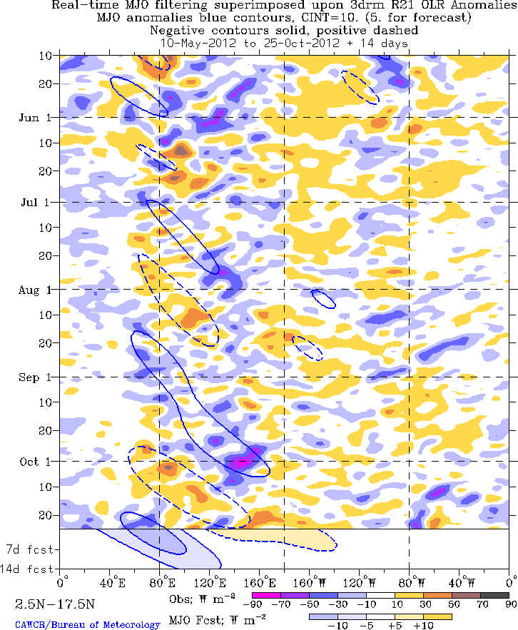
Figure 5: Time-longitude diagram of out-going longwave radiation (OLR) averaged over the northern tropics (2.5-17.5N). Blue regions show areas of reduced OLR, which is increased convection and shows the eastward progression of the MJO near the end of August 2012. Source: Matt Wheeler, the Centre for Australian Weather and Climate Research.
So the 2012 Indian summer monsoon season turned out to be 92% LPA, or 798mm rainfall against the usual 865mm when averaged over the country as a whole. This is much too small a deficit to be classed as a drought, but as one can see from the dramatic variability through the season in Figures 1, 2 and 4, thinking of the monsoon in terms of its seasonal mean area-average tells only part of the story.