Tropical cyclones (known as hurricanes in the North Atlantic) have huge economical and social effects including destruction of properties, influencing the price of gas and oil, and can cause substantial loss of life. When I decided to do my PhD, starting last October, on Tropical cyclones and climate change, motivation wasn’t hard to come by. The Atlantic hurricane season formally kicks off on June 1st and names such as Arlene, Emily, and Lee may soon be making headlines.
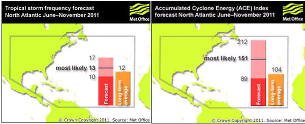
The Met Office issued its Atlantic hurricane forecast yesterday and predicts a near normal season in terms of the number of tropical storms with their best estimate at 13 tropical storms (70% chance, 10-17). A tropical storm has wind speeds between 39 mph and 73 mph. Tropical storms with winds speeds between 74mph and 111mph are known as hurricanes and major hurricanes are defined as having wind speeds greater than 111mph. The met office also forecast above normal activity of the ACE (Accumulated Cyclone Energy) index 151 (70% chance, 89-212). The ACE index is a measure of the collective intensity and duration of all tropical storms over the season (units are 10^4 knots^2).

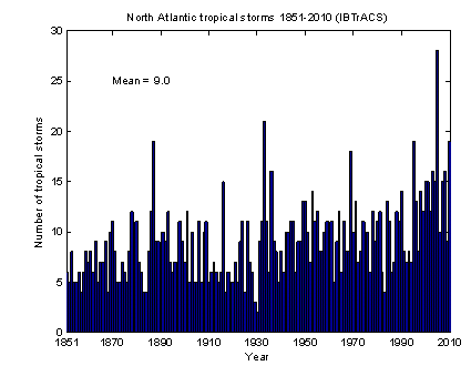
So how does the forecast this year compare to a normal Atlantic hurricane season? An average season has 12 tropical storms and an ACE index of 104 using a recent climatology of 1980-2010. The Met Office has predicted a normal number of tropical storms and an ACE index 50% greater than average, so I speculate this season could have more hurricanes (wind speeds > 74mph), and major hurricanes (wind speed > 111mph) than usual. Unfortunately, hurricane data before the advent of satellites, in the early 1970s, is not entirely reliable due to the lack of observations. As we travel further back in time, observations of hurricanes becomes even more sparse and prone to uncertainties, as many short lived storms far out at sea were often missed. Landsea et al. have spent many years extending the Atlantic hurricane record back to 1851 using historic newspaper cuttings, ship reports and even damage records. However, this shortness of a robust hurricane time series limits the ability to identify trends and will always be an issue when I put my climate change results into perspective.
 The forecast is the first public press release and unfortunately there is no related document explaining how the forecast is made. I comment below how last years forecast was produced but there may be a slight update to the model or methodology this year. The forecast was produced using a combination of their dynamical seasonal forecast model GloSea4 as well as ECMWF’s dynamical seasonal forecast model System 3. Both models use an ensemble prediction system with each forecast run with slightly different initial conditions. GloSea4 has 42 members and System 3 has 41 members, giving a robust 83 member ensemble forecast. The distribution of these members, around certain values (pdf), then gave the Met Office some meat in their final forecast. The final stage of their forecast involved making sure the model isn’t misbehaving. If hurricane numbers and the ACE index are significantly different from expected, the forecast was calibrated by using analogue years. These are years which had similar conditions in May to what we have now .
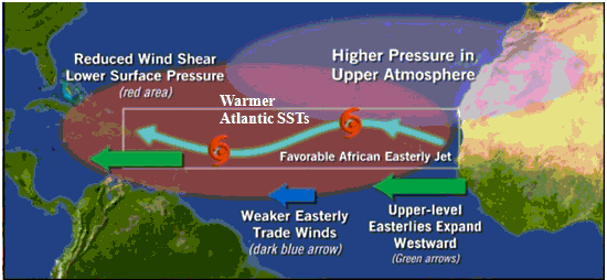
Sadly, without the supporting document I cannot say why the Met Office forecast 13 tropical storms and an ACE index of 151; they simply provide the numbers. I’m sure this information will soon follow. However, I can comment on how other centres using dynamical models created their forecast. NOAA predict a best estimate of 15 tropical storms and an ACE index of 152.5. They summarise the reasons in the figure below, which shows the forecasts of parameters (tropical Atlantic SST, NiNO3 SST and land temperatures over North Africa) from August to October – the most active time of the hurricane season. – which are known to influence hurricane activity (local SST, wind shear, African Easterly Jet)

Surely we can’t trust a forecast 6 months prior? The Met Office have been issuing hurricane seasonal forecasts since 2007 and therefore only give a handful of years directly comparable to observations. However, these forecasts have done very well. Last year the Met Office forecast 20(13-27) tropical storms along with an ACE index of 204(89-319). Observations showed was 19 and 170, respectively. As there has been a change in the seasonal forecast model over the years to give them some reliability of this years forecast they will most likely run a hindcast (forcing previous years with the known conditions in May) with their current model. Last’s year model gave a linear correlation of 0.33 with tropical storms and 0.61 with the ACE index from 1987-2009 using an 11 member ensemble. It will be interesting to see if they have used an updated model/method this year and what it’s hindcast skill is.
Other Atlantic seasonal forecasts including the veterans of statistical forecasting at CSU – who even issued a forecast back in December – predicting 17 tropical storms and an ACE index of 165, greater than the Met Office’s forecast. TSR predict a best estimate of 14.2 storms and an ACE index of 124, going for slightly more storms but a small ACE index. Only time will tell who’s right.
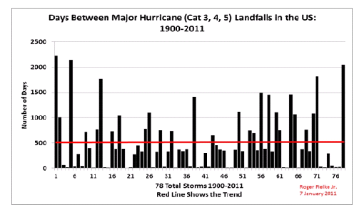
Most storms are likely to live out their lives in the North Atlantic, but it’s when they are close to the shore that most people take interest. It has been 5 years now since the US had a major hurricane strike (image below from Roger Pielke Jr.’s blog) – believed to be the third longest break since 1900 – so the million dollar question (or billion dollar question) is will there be any landfalls? and where?

Hi did you get any data from the met office? Are they allowing to use their API again?