“April doet wat hij wil” is a common saying in Dutch, meaning: “April does whatever it wants”, and suggesting that the weather in April couldn’t care less about any hosepipe ban. Indeed, even though we are in drought, we saw the wettest April on record in the UK. Interestingly, in their news release on April being the wettest in a century, the MetOffice also noted that “despite the heavy rain experienced this month, sunshine amounts so far this month have not been far off the average“. Thus, unless all the rain fell overnight, we will have seen plenty of isolated showers in April, bringing the ideal type of weather for the DYMECS project here at Reading.
DYMECS (the Dynamical and Microphysical Evolution of Convective Storms)
The DYMECS project is a collaboration between Reading and the MetOffice, aimed at studying the evolution of convective storms in observations and in the MetOffice forecast model. Our principal observations are made with CAMRa (Chilbolton Advanced Meteorological Radar) at Chilbolton, which we use to track storms with an automated scanning algorithm, retrieving high-resolution data on the microphysical and dynamical structures of these storms. Similar data will be extracted from the forecast model and separate model runs for sensitivity studies, which may show how a different representation of certain microphysical and dynamical processes can improve the evolution of convective storms in the model. In this blog, we will focus on how a single scanning day is approached by our team.
What is a perfect day for DYMECS?

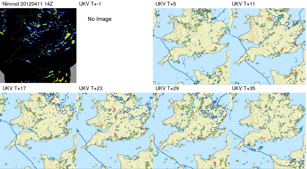
This set of forecasts for 3pm on Wednesday 11th April, 2012, shows the kind of rainfall pattern that indicates an abundance of convective storms. There are plenty of storms in the vicinity of Chilbolton (conveniently near the center of these plots) and when studying the animation, we see that the storms develop from small rainfall regions in the early afternoon to larger storm systems in the evening, so we may be able to track some of the storms as they evolve into bigger systems. The next step is to check with the people at the Chilbolton facility that the radar is available and – in case it’s a holiday or weekend – if someone will be around to turn it on and off for us!
Step 1: Identifying your target storm
In order to find out where the storms are in relation to Chilbolton, we use the MetOffice rainfall radar data (Nimrod), which is updated every 5 minutes and shows rainfall observations on a 1km grid. A basic flood-fill algorithm will identify individual rainfall regions, given an initial threshold (usually 1mm/hr) and assign each storm a label. For each labelled storm we then store its area, range and azimuth position relative to Chilbolton, maximum rainfall, and a whole host of other properties.
Step 2: Keeping track of your target storm

Since we want to make sure we keep tracking the same storm once we’ve decided it’s interesting, we also need to know where it’s going. First, we compare two consecutive Nimrod images (at times T-2 and T-1) and use a cross-correlation function to obtain the displacement of rainfall features from one to the next, which gives us u and v velocity fields. All the storms identified in the image from time T-1, S(T-1), are then advected by their mean velocity, to provide us their new locations at time T, S'(T-1). We compare the locations of these advected storms S'(T-1) with the actual storms observed at time T, that is S(T) and if there is enough overlap between two storms, we assign the storm at time T the same identifying label as the overlapping storm from time T-1. As you can see in the animation, this algorithm seems to keep track of the same storms (in the red boxes) quite convincingly.
Step 3: Blasting storms with microwaves!
To make efficient use of the radar, storms are mostly scanned if they are located in roughly the same region (see the animation). For the three or four most interesting storms, we do two types of scans:
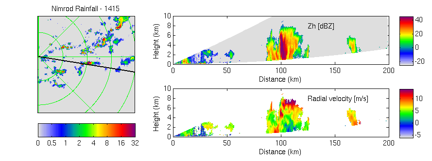
- A set of RHI (range-height indicator) scans at a fixed location through most intense rainfall, so that we can study the convective cores. An example of an RHI scan through a convective core is shown below. On the left, we see where this scan is in relation to the rainfall data. Top right shows the radar reflectivities, with a strong echo above 40 dBZ at about 100km, indicating that there might have been hail involved. We can also easily tell the height of the storm along the scan. Bottom right shows the radial velocity, derived through radar doppler measurements, which indicate the low-level convergence and upper-level outflow.

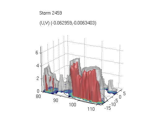
- A set of PPI (plan-position indicator) scans at different elevations, giving us slices through the storms at different heights, which can be reconstructed into 3D volumes so that we can study the full storm structure as it evolves. The figure below shows a set of PPI scans that have been collated and the isosurfaces of 5dBZ and 20dBZ are shown to indicate the extent of cloud (grey) and precipitation (red) of this storm. When the same storm is tracked throughout its life cycle, such 3D volumes will enable the analysis of storm area at different heights, for instance.

Step 4: Return to Step 1, or CTRL+C
At some point, either the storms will have moved out of the range of the radar or the working day is done (unless we’re very keen) and we get time to analyse the data. Our next steps will be to find the storms that we successfully tracked throughout a large part of their lifetime and plot out the evolution of some of their characteristics, such as area of rainfall, maximum height of a given reflectivity, and number of convective cores. Similar analyses will be done on storms in the MetOffice forecasts and sensitivity runs so keep an eye out for more DYMECS-related WCD blogs and presentations in the near future!