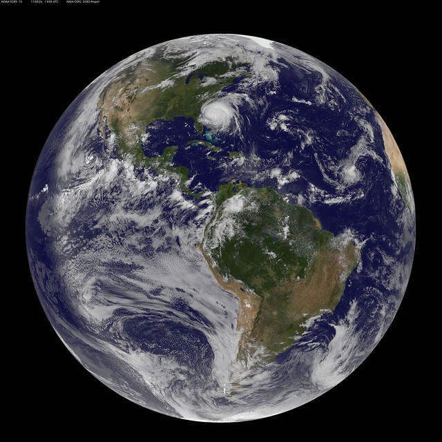
Hurricane Irene is currently travelling over warm Gulf Stream waters to the east of Florida, maintaining wind speeds of 110mph (sitting on the category 3 Saffir-Simpson Scale border), and is expected to make landfall in North Carolina mid day tomorrow (Saturday). Its current forecast track then takes Irene along the heavily populated east coast (with Hurricane winds striking New York) before dissipating over Maine. It is likely to bring ferocious winds, gusting up to 150mph, torrential rain, possibly reaching 300mm in isolated areas (fig. 1.) and a storm surge of 3m along the North Carolina coastline. As a result, 7 states along the east coast have declared a state of emergency and hundreds of thousands of people have been evacuated (http://www.bbc.co.uk/news/world-us-canada-14669374).

Exceptionally active season
On the 20th August Tropical Storm Irene became the 9th storm of the 2011 Atlantic season and later the first Hurricane. This marked the 2nd earliest date for formation of the season’s 9th storm, tied with 1936 and only behind the hyperactive season of 2005. However, all the storms so far have gone unnoticed due their offshore location and weak winds. Jeff Master’s write’s a great blog explaining why he believes this is the case (here).
The Met Office forecast 13 storms this season earlier in the year.
Warm SSTs
Hurricane Irene is currently tracking northward (recurvature of the hurricane is not expected for a couple days as the extra tropical circulation does not suggest a trough will push Irene out into the Atlantic (http://www.youtube.com/watch?v=xGJDGRLPzN8&feature=feedu) over warm Gulf Stream waters. The SSTs here are currently 28/29 oC giving hurricane Irene plenty of energy in terms of heat and moisture, which is then radiated out to space and dissipated as wind. However, this Hurricane is able to utilize energy from warm Ocean waters below the sea surface. As hurricane winds intensify the mixing becomes greater at the surface. Hurricane winds travel in a anti-clockwise direction around their central low pressure (opposite for the Southern hemisphere). The Ocean surface then ‘feels’ this wind which induces a current. The slow movement of the Ocean current is greatly influenced by the Earth’s rotation and therefore, the net depth integrated Ocean current moves to the right of the wind, under coriolis force (Ekman pumping). Movement of surface water away from the Hurricane usually causes cooler deeper waters to be upwelled from underneath (see figure in Shay (2009)). This usually provides a limit to the maximum wind speed a Hurricane can attain. In the case of Hurricane Irene the warm Gulf Stream waters extend deeper compared to waters to the east (the depth integrated water to 26.5oC is know as the Tropical Cyclone Heat Potential (TCHP)). As the winds of Irene are currently churning up the waters off the east coast of Florida the SSTs are unlikely to cool as much as usual due to Hurricane wind divergence over fairly warm waters.
An extreme example of hurricane intensification by this mechanism was shown by Hurricane Opal in 1995. It passed over a warm ocean eddy and its central pressure deepened from 965hPa to a scary 916hPa in just 14 hours (Shay et al, 2000).
Super Typhoon Nanmadol
Although all eyes are on the East Coast of the US (possibly due to the availability of media there compared to other regions of the world) a super typhoon is approximately 120km from the coast of the Philippines. Nanmadol’s wind speeds are forecast to reach a staggering 160mph by mid-day tomorrow (Saturday) and gusting even faster dwarfing the wind speeds present in Irene.
Hurricane Irene Links
For up to date information of all tropical cyclones world wide see my twitter feed.

Animation of Hurricane Irene’s lifecycle from GOES (http://www.youtube.com/watch?v=oDbGCYGulY8&feature=feedu)
Stay tuned to most US media channels for up to date reports on Saturday and Sunday.
References
Shay, Lynn K., Gustavo J. Goni, Peter G. Black, 2000: Effects of a Warm Oceanic Feature on Hurricane Opal. Mon. Wea. Rev., 128, 1366–1383
Shay, Lynn K. (2009) Upper ocean structure response to strong forcing events. Encylopedia of Ocean Sciences. pp. 3100-3114
1 thought on “Come on Irene”