By Andy Turner
Forecasting the monsoon in India continues to be a challenge for scientists, both for the season ahead and long into the future, the monsoon being vital for 80% of the country’s annual rainfall and securing the food supply for more than a billion people.
For years scientists have studied climate models from all over the world to understand why they don’t represent the monsoon well. But new observations are needed to help understand the processes involved, including how the land surface affects the timing of the onset and cessation of the rains, and how the deep convective clouds of the tropics work together with the monsoon winds that cover a much larger region.
 Figure 1. The summer months feature much stronger rains than winter over India (coloured blue over the land) as winds blow onshore from the Indian Ocean. Also shown are sea-surface temperatures. Notice the heavy rainfall on the west coast, caused by the influence of the Western Ghats mountains.
So this year, with the support of funding from the Natural Environment Research Council in the UK and India’s Ministry of Earth Sciences, that is what we started with our INCOMPASS project.
University of Reading and the Indian Institute of Science in Bengaluru (Bangalore) led a team of more than 10 universities, research institutes and operational forecasting centres to observe the monsoon in India from the air and on the ground.
After years of planning, this May we flew the NERC-owned Atmospheric Research Aircraft, a BAe-146 four-engine jet operated by the NCAS Facility for Airborne Atmospheric Measurement to India, as part of one of the largest observational campaigns that NERC has ever funded.
We based ourselves in two locations: the northern city of Lucknow, central to some of India’s most fertile land in the basin of the river Ganges, and in Bengaluru in the southern peninsular, equidistant between the heavy rains of the Western Ghats mountains and the drier land on the east coast. The aircraft returned to the UK in mid-July.
In the north we captured the monsoon onset: taking measurements as the monsoon progresses from east to west over the plains. How do the transitions between wet and dry soils affect the development of monsoon storms? How do the temperature and humidity change as we approach the Thar Desert in north-western India? By analysing our results over the next few years, we’ll find out.
In the south we gave more attention to the heavy rainfall over the Western Ghats mountains. How does this rainfall change during the day? What does the atmospheric boundary layer look like to the west of the mountains, over the Arabian Sea from where the moisture originates? Just as in the north, and as explained in our Planet Earth article, several of our flights took place only a few hundred feet above the ground, giving a spectacular, if bumpy, view of the landscape.
A research aircraft has the advantage of being able to cover large distances and measure large weather systems from different angles. But fuel and supporting the aircraft is expensive and requires a huge commitment of engineers & flight operations and instrument scientists at FAAM and the Met Office. To accompany these measurements, the INCOMPASS project also put in place a series of flux towers (installed by colleagues at CEH) at locations across India (Figure 2).

Figure 2. Towers like this one installed at IIT Kanpur by INCOMPASS colleagues at CEH will offer long-term measurements of fluxes of heat and moisture passed from the surface to the atmosphere. Photo (c) Andy Turner 2016.
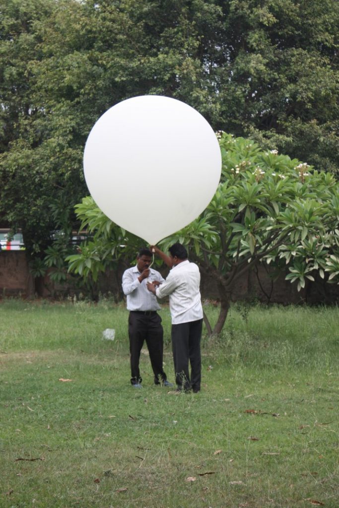
Flux towers are vital for measuring turbulent fluxes of heat and moisture as they migrate from the surface to the atmosphere. The information collected in 2016 and hopefully for years to come will help develop and improve the JULES land model, a vital component of the weather and climate models used by the Met Office. INCOMPASS also gave us the opportunity to use the Department of Meteorology radiosonde equipment. We based this at IIT Kanpur in northern India, close to our Lucknow airport base, and launched more than 100 balloons during the monsoon rains of July.

Figure 3. Scientists in India prepare to launch a radiosonde (weather balloon). Photo (c) Andy Turner 2016.
But what happens next? The team of scientists and students will spend the next few years analysing the vast datasets collected. With the Met Office and the NCAS Computational Modelling Services, we will be running model experiments at a variety of high resolutions to compare with our data for the 2016 monsoon. During the field campaign, we ran forecasts for India at 4 km resolution, but in the work to come we hope to perform tests below the kilometre scale to see how well we can re-forecast some of the storms in the monsoon.
