Some scientists are weird people. Take me as an example. It is summer, the sun is shining out there. Yet here I am, longing for autumn and winter and the storms they bring.
Don’t get me wrong. I still enjoy the sunshine, just waiting to go to the next BBQ. But while I wait for that to happen, I spend my time trying to understand more about the way autumn and winter storms produce their strong winds. These storms are also called extratropical cyclones. Giuseppe Zappa also wrote about these kind of cyclones a few weeks ago in this blog. In his contribution he discusses what changes we might expect with climate change.
I am sure that many of you remember last autumn and winter and the many storms they brought. It was a period of really strong winds, not to mention the large amount of precipitation that caused so much flooding in the UK. Just to give an example of one of these storms we can mention St Jude’s Day Storm on 28 October 2013. It caused disruption in southern England and Europe, reaching Denmark with full force and winds of more than 120 mph (50 metres per second). Several people died in England and Europe on that day because of this storm.
To understand more about how the strong winds are produced in these storms, we scientists need observations, ideally from inside the storm. But of course not many people want to go up there to measure pressure, humidity and temperature in the centre of a storm and so we have to do it ourselves with the invaluable help of fantastic pilots. That is precisely what we did during storm Friedhelm on 8 December 2011. This flight took place as part of the DIAMET project, a large science collaboration between four British universities (Manchester, East Anglia, Leeds and, of course, Reading) and the Met Office. The research aircraft we used was a modified BAe-146-301 large Atmospheric Research Aircraft (ARA) operated by the Natural Environment Research Council (NERC) and the Met Office. If you are interested to read more about the flight you can do that in a short article we published in Weather (Baker et al. 2013).
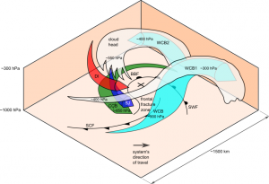
The observations we took as we flew through storm Friedhelm allowed us to learn a great deal about this kind of storm. For example comparing these observations and the output of our numerical models we managed to establish the trajectories followed by the high-speed damaging wind. It might sound simple, but if you think about it this is not a trivial achievement. Following a volume of air as it travels through the atmosphere is not easy, especially when this air is part of such a complex phenomenon like an extratropical cyclone. To stress this point Figure 1 illustrates the many different airstreams inside these cyclones. If you are interested in knowing more about how we did this and what else we learnt from doing it you can read our article in Monthly Weather Review or ask us for a copy (Martínez-Alvarado et al. 2014).
Figure 1. The many air streams inside an extratropical cyclone. The X represents the cyclone centre and the black lines with symbols represent the surface cold front (SCF) and the surface warm front (SWF). The arrows represent air streams: cyan – warm conveyor belt rising and splitting into two sub-streams (WCB1 and WCB2), red – dry intrusion (DI) descending towards the cyclone centre, blue – sting jet (SJ) and green – cold conveyor belt (CCB). The white shading represents cloud top (Martínez-Alvarado et al. 2014).
This was not the only interesting storm the DIAMET team flew through. In fact, there were four field campaigns during 2011 and 2012. All of them were very successful, producing observations of many different weather patterns, during winter and summer. Keep visiting this blog as we will describe more of these flights in future entries.
References
- Baker, L., O. Martínez-Alvarado, J. Methven, and P. Knippertz (2013) Flying through extratropical cyclone Friedhelm. Weather 68, 9–13. DOI: 10.1002/wea.2047
- Martínez-Alvarado, O., L. H. Baker, S. L. Gray, J. Methven and R. S. Plant (2014) Distinguishing the cold conveyor belt and sting jet air streams in an intense extratropical cyclone. Mon. Weather Rev. In Press. (link)

