By Hannah Cloke Department of Meteorology
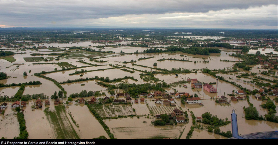
Weeks of rainfall followed by significant rainstorms between 13-16 May 2014 led to widespread flooding in the Balkans (Figure 1). Bosnia-Herzegovina and Serbia were particularly affected, with severe flooding also reported in several other regions including Poland, the Czech Republic and Slovakia.
Figure 1. Pictures from a Slovenian helicopter crew as they provided assistance in Bosnia and Herzegovina. Photo credit: EC/ECHO/EEAS/EU Delegation BiH – 19 May 2014.
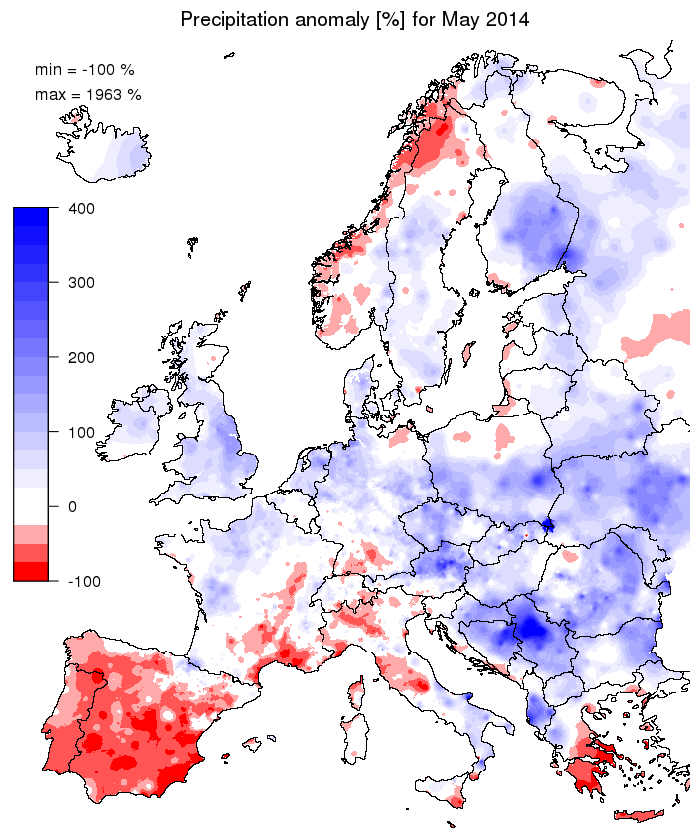
The month leading up to the severe rainfall was wet with more than 200% of the normal rainfall for this time of the year (Figure 2). The 3-day period with the highest rainfall accumulations started on 13 May with rain along a cold front and strong westerlies: the heaviest rain fell in parts of Serbia and Bosnia. The highest observed values were in a band from Tuzla in the west to Belgrade in the east, with more than 160 mm/3 days. The four highest totals were Tuzla (264 mm), Loznica (213 mm), Valjevo (190 mm) and Belgrade (174 mm).
Figure 2. Observed precipitation anomaly [%] for May 2014, relative to a long term average (1990-2011).
More than 60 people died in the flood-affected regions of Bosnia-Herzegovina and Serbia with a serious loss of livestock. More than a million inhabitants were estimated to have been affected by this flood event, including the awful cases of unexploded mines floating to the surface of the wet ground. Both Bosnia-Herzegovina and Serbia activated the EU Community Mechanism for help in the afternoon of 15 May and again on the 17th for further assistance for Bosnia-Herzegovina. Effective disaster risk management relies on science based solutions to close the gap between prevention and preparedness measures. The European Flood Awareness System (EFAS) is one system implementing such solutions by providing probabilistic flood forecasting information to national authorities within Europe as well as to the Emergency Response Coordination Centre (ERCC) of the European Commission up to 10 days before a flood event. The EFAS has been running operationally at ECMWF since 2013 and was able to demonstrate its early warning capabilities in the Balkan floods of 2014 by providing this early warning information.
When predicting severe floods an early signal is invaluable for disaster preparedness mechanisms to be activated, where preventative actions include closure of barriers, placement of temporary flood defences and residents preparing their homes for flooding. At longer lead times (i.e. further in advance) the forecast may be less able to pinpoint with certainty the exact severity, timing and location of a flood, but even small probabilities can initiate valuable preparations such as ensuring incident rooms are staffed, monitoring gauges more closely, stepping up modelling activities and in particular for the ERCC undertaking detailed scenario planning and preparing emergency assistance.
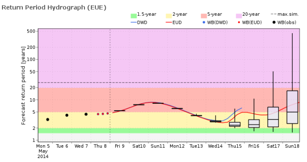
For the Balkans, it was possible to predict the extreme rainfall relatively early due to the large scale forcing of the event. However, rainfall forecasts alone cannot be used to forecast floods accurately, as the complexity of the land surface and the variable response times of river catchments mean that we have to be able to model the antecedent conditions, the hydrological processes of runoff and the routing of water down rivers in order to predict when and where it will flood and how bad that flood will be. The EFAS forecasts for the Balkans case were able to indicate extreme streamflow on 9 May, the earliest forecast that covered the day of peak flow, allowing early information to be provided to national authorities and the ERCC. Figure 3 shows the streamflow predicted for the river Sava for a point close to Belgrade, where ensemble members indicated a 500 year flow return value for 18 May.
Figure 3. EFAS forecast showing return period hydrograph for the flow in river Sava for a point close to Belgrade initialised for 9 May 2014. Courtesy of EFAS/ECMWF.
Although such improvements in the provision of early flood information are admirable, there remain many technical and communication challenges that remain for probabilistic flood forecasts to achieve their full potential (Stephens & Cloke, 2014). A comparison of current EFAS system skill compared against perfect forecasts demonstrates the importance of further improving the skill of the forecasts. Improving the response to warnings is also essential in reaping the benefits of flood early warnings. This includes working out exactly how early warning information is used by forecast recipients, understanding how to link forecast thresholds to flood impacts and how to prompt forecast recipients (response decision makers) to operate within a probabilistic mindset. These are some of the challenges that are actively being researched within the Hydrology Research Cluster at the University of Reading, where, working closely with partners such as EFAS, we are developing techniques to improve local scale through to global scale flood forecasting systems.
References
EFAS (2014) EUROPEAN FLOOD AWARENESS SYSTEM: Bimonthly Bulletin – Issue 2014(3). www.efas.eu
Magnusson, L, F. Wetterhall, F. Pappenberger and I. Tsonevsky, 2014. ECMWF newsletter No. 14, Reading, United Kingdom, pp 5-6. www.ecmwf.int
Stephens, E. and H. Cloke, 2014. Improving flood forecasts for better flood preparedness in the UK (and beyond). Geographical Journal, 180 (4). pp. 310-316. ISSN 1475-4959 doi: 10.1111/geoj.12103
HEPEX, 2014. http://hepex.irstea.fr/balkans-worst-floods-for-more-than-100-years/.


