I was concerned to read this warning published recently in a national newspaper, partly because to roast me would require perhaps 200 °C for quite a few hours, but to boil the air (see lower down the article) would require (for Nitrogen anyway) a rather cool -196 °C. Perhaps if the roasting/boiling air were to be mixed, it could probably be comfortable?
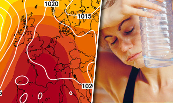
HEATWAVE WARNING: Shock new weather maps show how Britain will ROAST in next 72 hours
BRITAIN is set to roast in sizzling temperatures of up to 40C (104F) within hours as the most extreme heatwave in living memory grips the country.
By Nathan Rao & Levi Winchester
PUBLISHED: 00:30, Tue, Jun 30, 2015 | UPDATED: 07:49, Tue, Jun 30, 2015
 TheWeatherOutlook.Com
“The Spanish Plume of soaring heat will envelop Britain by 9 am on Tuesday.
New weather maps show a huge plume of boiling air pushing north into much of the UK by tomorrow morning. By Wednesday the whole country will be sweltering – both by day and night – as uncomfortable, muggy conditions take hold amid warnings to stay indoors to avoid the near-record high temperatures. It comes as it emerged Wimbledon matches could be SUSPENDED this week as the heatwave from Africa hits the All England Club. Worried chiefs have already issued warnings to fans and VIP visitors”.
The warning of the heat took me to Roger Brugge’s and Stephen Burt’s very recent volume “One hundred years of Reading weather”, just to check what this campus’ record high temperature is. The mercury reached 36.4 °C on 10 August 2003.
That got me thinking about the incidence of “hot” weather here – say days when the maximum was 30 °C or greater. So I trawled through the Department’s Atmospheric Observatory data bank to produce a few statistics.
Here’s the incidence of such values for dekads (save 21-31 July) since 1968:
1-10 June 0 11-20 June 1 21-30 June 9 1-10 July 13 11-20 July 19
21-31 July 14 1-10 August 17 11-20 August 2
and the incidence during (arbitrary) five year periods from 1968 till the present:
events in n years events in n years
1968-1972 3 3 1993-1997 11 4
1973-1977 16 2 1998-2002 7 3
1978-1982 0 2003-2007 16 3
1983-1987 7 1 2008-2012 4 1
1988-1992 9 2 2013-2015 so far 4 2
The well-known summer of 1976 experienced 14 consecutive days of maximum temperatures of 30 °C or more from 25 June to 8 July inclusive. In 2003, eight such days were recorded and seven in 2006.
The synoptic ‘climatology’ of many of these occurrences is not surprisingly one of southerly or south-easterly airflow from a strongly heated France, persistently sunny days and of dry surface conditions.
The plume from Spain must flow over the plain
France plays a key role too in the genesis of severe convective storms that sometimes reach our southern shores and progress inland. The particular region is north of the Pyrenees – low-lying Aquitaine and northwards. The Spanish Plume is a southerly current that traverses the strongly heated, dry, elevated Meseta (Madrid is some 650 metres above sea level for example) – typically ahead of a trough moving in from the Atlantic.
The southerly, high Ө air flows across the Pyrenees and on across western France as a ‘plume’ above warm, moister air in the lowest km or two. The Spanish air acts as a lid to strong convective development, with shallow convection simmering away earlier in the day until – the surface temperature reaches a critical value such that deep convection can explode rapidly through the ‘cap’. The same phenomenon occurs in the US Southern High Plains where warm, moist Gulf air is overrun by much hotter, drier air from northern Mexico.
So, get rid of the Meseta and, probably, get rid of many of our severe convective storms.
Summer daytime heating over south-west France, for example, does of course spark deep convection that can be long-lived when growing in a favourable vertical windshear environment.
All this reminded me of my puzzlement when a teenager living near the Solent as to why spectacular summertime thunderstorms sometimes occurred at night. I wasn’t of course aware that they could well have formed over France and drifted across the Channel in the dark. Interestingly, this was a year or two before Carlson and Ludlam’s 1968 Tellus paper in which the term ‘Spanish Plume’ was perhaps first coined.
So the reporters were right about the risk of extreme heat, though not about the “in living memory “ bit. It was of course just one day of risky heat (see ‘Phew! What a scorcher!’ And they missed the important aspect of the Plume – that of the risk of localised-flood producing storms, large(ish) hail and lightning – the latter sadly to fatal effect on the bare, exposed Brecon Beacons.
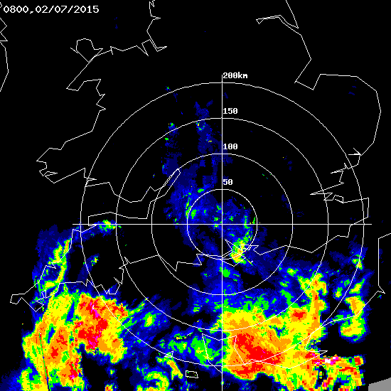
The uncorrected radar images below illustrate the progression of deep convection originating over France, moving north to threaten southern England from 0600 to 0800, 2 July 2015.


