What is El Niño, how often does it occur, and why is everyone so concerned this year?
El Niño is the warming phase of the El Niño Southern Oscillation (ENSO). During an El Niño event, the central to eastern tropical Pacific warms by 0.5-2 degC or more for anything between a few months to two years. El Niño occurs, on average, every three to seven years. It impacts weather systems around the globe so that some places receive more rainfall while others receive none at all, often in a reversal of their usual weather pattern.
There were super El Niño events in 1972-73, 1982-83 and in 1997-98, the latter bringing record global temperatures alongside droughts, floods and forest fires. The current El Niño has already affected millions of people and comes on top of already volatile and erratic weather patterns linked to climate change. Globally, 2014 and 2015 were the hottest years on record, with the Pacific Ocean already warming up to an unprecedented degree.
El Niño in West and Central Africa
Experts have confirmed that unusual high surface temperatures at the end of 2015 and in January 2016, above the annual increase, are an indication that El Niño could have possibly impacted West and Central Africa (particularly in Chad, Cameroon and the Democratic Republic of the Congo) from September 2015 to March 2016. However, since January 2016, a decrease in ENSO intensity was noted. Most model outputs and expert assessments have suggested a persistence of this decreasing trend leading to ENSO neutral conditions starting from May 2016.

Figure 1. Source: http://www.unocha.org/el-nino-west-central-africa

Figure 2. Source: http://www.unocha.org/el-nino-west-central-africa
Predictions – June to September 2016 for West and Central Africa
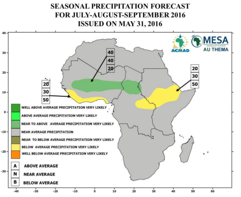
Figures 1 and 2 show the seasonal temperature and precipitation that were forecasted for July to September 2016, while Figure 3 shows significant weather and climate events expected from June to September 2016.
- Below average precipitation was very likely from July to September 2016 over the west part of Guinea, Sierra Leone, Liberia, southern Côte d’Ivoire, Ghana, Togo Benin and Nigeria, southeastern CAR, Sudan, northern DRC, Uganda and most of South Sudan and Ethiopia.
- Near to below average precipitation was very likely over the most of the coastal part of Mauritania, Senegal, Gambian and Guinea Bissau, the Gulf of Guinea from Sierra Leone to Nigeria during June to August period.
- Over the northern Guinea, central Sahel region, near to above average precipitation was very likely from June to September 2016.
- Near to above average temperature was very likely over most part of northern Africa, the Sahel region and southern Africa from June to September, 2016.
- Above average temperature was very likely during June to September 2016 over Morocco, Algeria, Tunisia, northern Libya, northern and eastern Egypt, northernmost Mauritania and Mali.

Figure 3. Source: http://www.unocha.org/el-nino-west-central-africa
