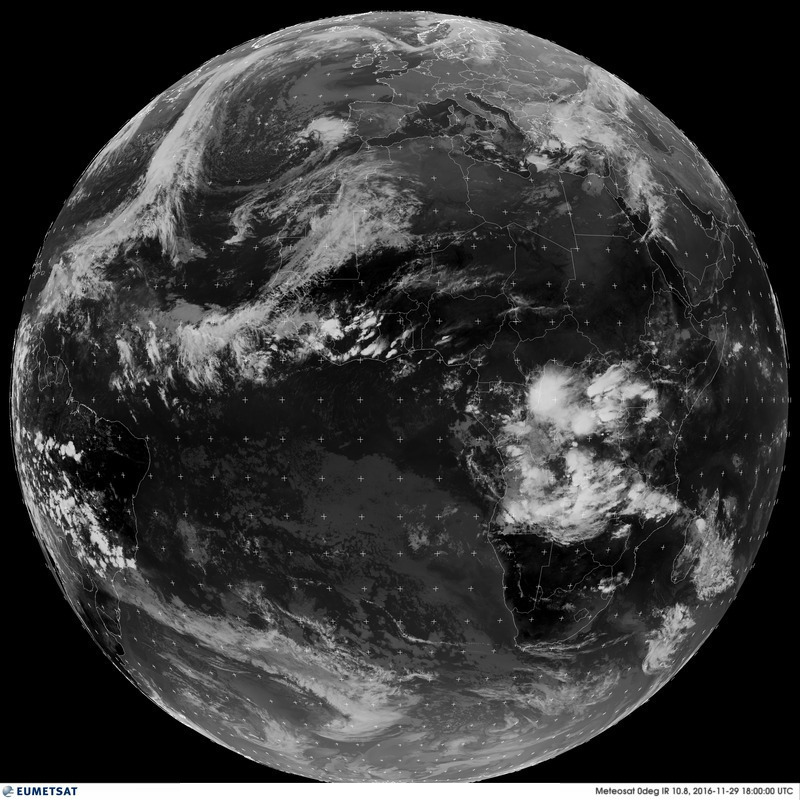
The University of Reading’s TAMSAT group ( www.tamsat.org.uk ) have helped pioneer the use of satellite imagery in rainfall estimation across Africa since the early 1980s when the group was first established. Thanks to some bright and innovative minds back in the day, it was quickly realised that the availability of frequent thermal infrared satellite images providing full coverage of the African continent (e.g. Figure 1) could readily be used to observe the cold tops of rain-bearing convective cloud systems, and in turn, produce much needed information on where and how much rainfall has likely fallen. Given the high dependence on rainfall for many socially and economically important activities across sub-Saharan Africa (namely those in agriculture) and the severe lack of raingauges across much of the continent, this satellite-based alternative proved an extremely useful resource to monitor rainfall conditions and forewarn to impending water shocks, such as drought or flooding.

Figure 1. Meteosat thermal infrared image from 29 November 2016, 1800 UTC (Source: www.eumetsat.int). White scenes denote cold cloud tops, while black/dark grey scenes denote the warmer land or sea surface.
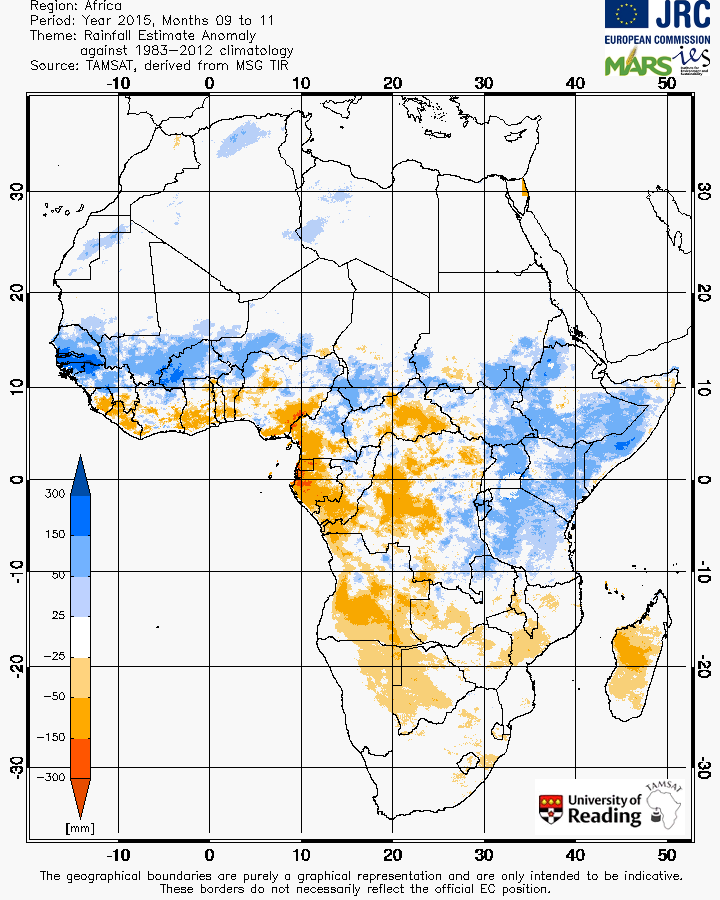
More than three and a half decades on, the TAMSAT group still provide operational rainfall estimates (e.g. Figure 2) to all of Africa using a simple, yet effective rainfall estimation algorithm which is based on the use of cold cloud duration (CCD) fields derived from the satellite imagery. Over the years, many African meteorological services and other agencies or organisations have depended on this data for a range of applications such as flood and drought monitoring, famine early warning and weather index-based insurance schemes (e.g. Figure 3), helping millions of people to manage the highly variable rainfall climate that characterises much of the African continent.

Figure 2. The TAMSAT seasonal rainfall anomaly for September-November 2015 with respect to the 1983-2012 climatology (Source: www.tamsat.org.uk). The seasonal anomaly, derived from 10-day total rainfall estimates, shows the impact of the 2015 El Niño event on African rainfall (namely, a wetter East Africa and drier Southern Africa).

Figure 3. A weather index-based insurance workshop in Zambia where the use of TAMSAT data in insurance products are being discussed (Photo credit: Agrotosh Mookerjee).
In an era where there is an increasing amount of satellite-derived rainfall products, many of which are based on new and highly sophisticated sensors, it is reasonable to assume that the TAMSAT data, given it is based on a relatively simple method, may no longer be as useful. However, the strength of the TAMSAT data lies in its longevity and consistent estimation algorithm. For many applications, a short rainfall time-series makes it very difficult to assess the severity of unexpected changes in rainfall when the average or climatological conditions are not well known. The long time-series of the TAMSAT archive (since 1983) and its operational system ensures that new estimates are created on a regular basis, making the TAMSAT rainfall dataset a highly valuable resource, for both climate-based operational activities (e.g. Black et al 2016) and climate research (e.g. Maidment et al 2015).
So what next for TAMSAT? During the last 12 months, the TAMSAT group have invested huge efforts into overhauling their estimation algorithm, and in doing so, minimising several of the characteristic problems associated with the previous algorithm. In addition, and with the help of collaborators at the International Research Institute at Columbia University, the group have developed novel techniques to provide uncertainty rainfall estimates (which surprisingly many rainfall datasets do not issue) and merging of auxiliary information (such as raingauge measurements) with the satellite data to improve the estimation of rainfall intensities over short time periods. It is planned that these products will be run operationally alongside TAMSAT’s primary rainfall product during 2017, and also in a rainfall monitoring platform currently deployed in several countries across West and East Africa.
The activities described here, amongst others, ensures that TAMSAT are delivering both skillful and reliable rainfall products that are much needed in a region of the world that is deprived of adequate rainfall information, and at the same time, is challenged by marked climate variability and human-induced climate change which is expected to exacerbate current conditions in the near future.
References
Black, E., E. Tarnavsky, R. Maidment, H. Greatrex, A. Mookerjee, T. Quaife, and M. Brown, 2016: The Use of Remotely Sensed Rainfall for Managing Drought Risk: A Case Study of Weather Index Insurance in Zambia. Remote Sens., 8, 342. http://www.mdpi.com/2072-4292/8/4/342/htm
Maidment, R. I., R. P. Allan, and E. Black, 2015: Recent observed and simulated changes in precipitation over Africa. Geophys. Res. Lett., 42, 2015GL065765. http://dx.doi.org/10.1002/2015GL065765
