In late 2015 and early 2016 a strong El Nino event, characterised by warmer than normal temperatures in the Pacific Ocean, developed and led to a variety of global effects. These included drier than normal weather in Indonesia and the Philippines, wetter than normal conditions over parts of South America and warmer, wetter conditions over much of the south in the United States.
Since El Nino reached its peak last November, forecasters have turned attention to the possible development of a La Nina event in late 2016 and early 2017. La Nina events, characterised by prolonged cooler than average temperatures in the Pacific Ocean, often (but not always) develop following a strong El Nino event. The timing and strength of such an event can have a variety of implications for climate patterns worldwide (see Figure 1). Organisations such as the Department for International Development (DFID) are therefore interested in monitoring the development of conditions in the atmosphere and oceans associated with a La Nina, as well as understanding the potential impacts of a La Nina event across certain vulnerable regions. These potential impacts are assessed by combining information from analysis of historical impacts during previous La Ninas, climate model forecasts that predict 1-3 months ahead and by monitoring current climate conditions across the globe.
Figure 1: Potential global impacts of a La Nina event. Source: http://www.pmel.noaa.gov/elnino/lanina-faq
Following the 2015/16 El Nino, conditions in the Pacific returned to neutral (neither an El Nino or a La Nina) in the spring of 2016. Sea surface temperatures in the Central Pacific have been significantly below average over the last three months, consistent with the formation of weak La Nina conditions. However temperatures across the whole Pacific region have not cooled as much or as quickly as predicted earlier in the year, suggesting that if a La Nina does develop it will likely be a weak event.
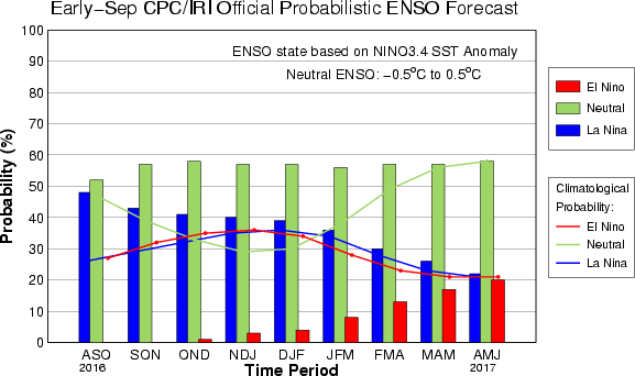
Forecasts made earlier in the summer suggested La Nina conditions were slightly favoured (with around a 55-60% chance) to develop during late 2016. More recent forecasts have suggested a diminished likelihood of a La Nina event developing, with Pacific Ocean temperatures predicted to be near-normal for the remainder of 2016 (see Figure 2). Some models still indicate a possible weak La Nina event this winter, although many other phenomena associated with La Nina are either absent or only weakly present in the models, causing forecasters to downgrade their predictions.

Figure 2: CPC/IRI Official Probabilistic El Nino Southern Oscillation (ENSO) forecast from September 2016. Probabilities for El Nino, neutral, or La Nina conditions for each three-month period during late 2016 to early 2017. Neutral ENSO conditions are currently favoured over the coming months. Source: http://iri.columbia.edu/our-expertise/climate/forecasts/enso/current/?enso_tab=enso-cpc_plume
The potential absence of a La Nina event over the coming months has consequences beyond the just Pacific region. This includes implications for how the tropical cyclone and Atlantic hurricane seasons may develop, as well as the impacts of changes in rainfall patterns, which can lead to flooding or drought, particularly across parts of Africa and Asia. Current predictions suggest East Africa is likely to see drier than average conditions over the next three months, consistent with expectations during a La Nina event, but there is no clear consensus about rainfall patterns across the rest of Africa, for example. La Nina conditions also typically lead to lower temperatures, so in the absence of this event temperatures across much of the globe are expected to continue to be above normal throughout the end of 2016 and into 2017 (see Figure 3).

Figure 3: Global long-range temperature forecast for October/November/December 2016 from the UK Met Office (issued in September 2016). There is an increased probability of above normal temperatures over much of the globe during the next three months, while temperatures in the Pacific have an increased probability of being near normal. Original source: http://www.metoffice.gov.uk/research/climate/seasonal-to-decadal/gpc-outlooks/glob-seas-prob

