
By: Robert Lee
The winter weather in the UK and Europe can be split into different patterns based on the large-scale flow in the atmosphere. A commonly used method is to use a type of machine learning algorithm – a clustering algorithm – to partition the weather into distinct categories, known as ‘regimes’. Weather regimes can persist for a number of days or even weeks, before transitioning to another regime. Using large-scale weather regimes such as these are useful when considering the ‘subseasonal’ forecasting period, approximately 10–20 days ahead since they give an approximate indication about the average weather covering many countries for many days, without focusing on precise differences on a local and hour-by-hour scale, which cannot be forecasted well due to the inherent chaos.
For the combined North Atlantic and European region, it turns out that the optimal number of large-scale weather regimes is four [1]. These regimes are often called the (1) NAO− (a.k.a. Greenland Blocking), (2) NAO+ (a.k.a. Zonal), (3) Atlantic Ridge, and (4) Scandinavian Blocking. As a side note, the NAO− and NAO+ weather regimes are similar, but not identical, to the North Atlantic Oscillation index. Figure 1 illustrates the differing winter weather conditions under each regime. For example, NAO− brings colder and calmer conditions to the UK and North Sea region, while NAO+ brings milder, windier and wetter conditions.

Figure 1: Anomalies of temperature, wind, and rainfall (precipitation) during the extended winter season during each of the four weather regimes.
Subseasonal forecasts of weather regimes can help authorities and businesses to plan ahead in sectors such as agriculture, energy, health, aviation and transportation, water, and retail. In the energy sector, for example, if NAO− weather is forecasted, then the energy industry can plan for a ‘shortfall’ in electricity [2]. A shortfall is caused when the demand exceeds the supply, due to increased electricity used for heating in the colder weather. A (growing) proportion of the electricity supply comes from wind generation: during NAO− days the winds are much calmer. Similarly in the health sector [3], a heads-up about an upcoming period of NAO− can aid preparations for an increase in average and peak (extreme 5-year return interval) hospital admissions and mortality in the UK, associated with the colder conditions.
Remote atmospheric links from other regions, known as ‘teleconnections’, provide a way of getting an advanced warning for upcoming weather, thereby improving the potential for predictions on subseasonal timescales. For over 30 years there has been a known link between weather in the tropics and weather in the North Atlantic and European region that exists on these subseasonal timescales [4]. These links are primarily driven by a weather phenomenon in the tropics known as the Madden-Julian Oscillation (MJO), which is an eastward moving ‘pulse’ of suppressed and enhanced cloud and rainfall near the equator which typically recurs every 30 to 60 days during the boreal winter (although the MJO is not active about one third of the time). An important study in 2008 [5] showed how these teleconnections from the MJO in the tropics influence the weather regimes in the North Atlantic and European region. The study also showed how packets of energy, known as ‘Rossby waves’, can travel eastwards from the Pacific to the North Atlantic in the jet streams of the atmosphere, revealing some of the physics involved in these teleconnections.
At the inception of our study [6], the El Niño–Southern Oscillation (ENSO) was hypothesised to also play a role in altering these teleconnections. ENSO characterises the periodic variation of sea surface temperatures and accompanying atmospheric circulation over the tropical Pacific Ocean. The warm phase is known as ‘El Niño’, and the cool phase as ‘La Niña’, reaching peak intensity during boreal winter. The Pacific sea surface temperature is commonly split into three categories: (1) El Niño, (2) neutral, and (3) La Niña, as shown in Figure 2.

Figure 2: Sea surface temperature anomalies in the tropical Pacific during the extended North Hemisphere winter season, under El Niño, neutral, and La Niña conditions.
ENSO conditions change on a longer (slower) timescale than the MJO, and so from a subseasonal perspective, ENSO conditions remain approximately constant. We find that ENSO modifies the MJO [6], making these regions of wet and dry weather narrower or broader in longitude (Figure 3).
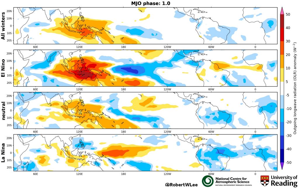
Figure 3: The classic animation of the MJO (top row), here shown as an Outgoing Longwave Radiation (OLR) anomaly (to represent the clouds); and during El Niño, neutral, and La Niña conditions (lower three rows). The phase of the MJO is labelled at the top.
This ENSO modification of the MJO then has a consequence on the type of teleconnection that is triggered and the path that it takes. Our study [6] shows that during El Niño winters the teleconnection from MJO phases 1–3 makes the NAO+ regime occur twice as often as the full climatology, with the signal travelling along the jet streams (Figure 4). Whereas during La Niña this MJO phases 1–3 teleconnection is absent and there is no increase in NAO+ regime occurrence. During La Niña years we also find the teleconnection from the MJO phases 6–8 makes the NAO– regime occur up to 2.5 times as often as the full climatology – this signal travels via the stratosphere, warming it and slowing the stratospheric polar vortex (Figure 4), with the total pathway taking around 20 days. There is a strong subseasonal link between the stratospheric polar vortex and the weather regimes throughout all winters [7], however, it is during La Niña years when there is the strongest subseasonal link between the MJO and the stratosphere [6].

Figure 5: Simplified schematic of teleconnection from MJO phases 3 and 7, to the North Atlantic and European region during El Niño and La Niña conditions, respectively. Schematic adapted from: [6].
This statistical method, using the ENSO and MJO conditions, indicates which weather regimes we might expect 10-20 days in advance. By combining this with dynamical models, which can forecast the MJO up to 10 days ahead, we may improve the weather outlook for up to 30 days ahead. These results have important implications, including for the achievable skill in predicting these weather regimes on subseasonal timescales. In addition, this dependence of the teleconnections on the ENSO state should be well represented in weather and climate models. Finally, long term changes (both past and future) in MJO amplitude and in ENSO strength, may alter the proportions of time in each the weather regimes experienced overall.
This work [6 & 7] is part of the InterDec project, connecting scientists from 6 countries, researching inter-regional linkages on subseasonal-to-decadal timescales, and has been funded by NERC via the 2015 joint call from the Belmont Forum and JPI Climate.
References:
-
Michelangeli, P.-A., R. Vautard, and B. Legras, 1995: Weather Regimes: Recurrence and Quasi Stationarity. Atmos. Sci., 52, 1237–1256, https://doi.org/10.1175/1520-0469(1995)052<1237:WRRAQS>2.0.CO;2
-
Wiel, K. Van Der, H. C. Bloom, R. W. Lee, L. P. Stoop, R. Blackport, J. A. Screen, and F. M. Selten, 2019: The influence of weather regimes on European renewable energy production and demand. Res. Lett., 14, 094010, https://doi.org/10.1088/1748-9326/ab38d3
-
Charlton-Perez, A. J., R. W. Aldridge, C. M. Grams, and R. Lee, 2019: Winter pressures on the UK health system dominated by the Greenland Blocking weather regime. Weather Clim. Extrem., 25, 100218, https://doi.org/10.1016/j.wace.2019.100218
-
Ferranti, L., T. N. Palmer, F. Molteni, and E. Klinker, 1990: Tropical-Extratropical Interaction Associated with the 30–60 Day Oscillation and Its Impact on Medium and Extended Range Prediction. Atmos. Sci., 47, 2177–2199, https://doi.org/10.1175/1520-0469(1990)047<2177:TEIAWT>2.0.CO;2
-
Cassou, C., 2008: Intraseasonal interaction between the Madden–Julian Oscillation and the North Atlantic Oscillation. Nature, 455, 523–527, https://doi.org/10.1038/nature07286
-
Lee, R. W., S. J. Woolnough, A. J. Charlton‐Perez, and F. Vitart, 2019: ENSO modulation of MJO teleconnections to the North Atlantic and Europe. Res. Lett., 46, 13535– 13545, https://doi.org/10.1029/2019GL084683
-
Charlton-Perez, A. J., L. Ferranti, and R. W. Lee, 2018: The influence of the Stratospheric state on North Atlantic Weather Regimes. J. R. Meteorol. Soc., 144, 1140– 1151, https://doi.org/10.1002/qj.3280