By: Arathy Menon
The Indian monsoon provides water for agriculture, industry and the basic water needs of more than a billion people. The monsoon onset usually takes place in south India during the beginning of June and the monsoon rains then advances in a north-westward direction, over a period of six weeks, covering the entire country by around mid-July. It is interesting to note that the monsoon rains progress in a direction perpendicular to the direction of the mean winds which are southwesterly during the monsoon season from June to September.

Figure 1: An animation showing the progression of the monsoon onset isochrones (Courtesy: India Meteorological Department).
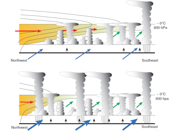
Based on an observational dataset, Parker et al., (2016) showed that during the beginning of the monsoon season, northwesterlies prevail in the mid-troposphere, and they carry dry air from the Afghanistan region right across the Indian subcontinent as far as the southeast coast of India. During the pre-monsoon period, this layer of dry air in the mid-troposphere suppresses deep convection and rainfall. As the monsoon season begins, these northwesterlies are moistened by the moist monsoon winds which support the development of shallow cumulus and congestus clouds, slowly eroding the dry-air intrusion from the southeast. As the season develops, the northern limit of the onset progresses towards the northwest as the rate of moistening of the dry layer from southeast increases, relative to the horizontal advection of the dry air from the northwest. Volonté et al., (2020) elaborated on this finding by showing that the north-westward progression of the monsoon is a non-steady process modulated by the balance of the interaction between the moist monsoon air mass and the dry northwesterly air mass.

Figure 2: A schematic from Parker et al., (2016) showing the situation around the time of onset (around the 1st of June, top panel) along northwest-southeast India, when the dry layer is still quite deep in the southeast but has been sufficiently moistened to allow the onset of deep convection there. The bottom panel shows the situation around the 15th of July when the onset has advanced to the northwest and the dry layer extends only a few hundred kilometres into the subcontinent.
In one of our recent pieces of research, we used the Met Office Unified model at 4 km grid-spacing and found that the land-atmosphere interactions also play a major role in the advance of the monsoon by modifying the local onset. During the beginning of local onset over a region, onset or pre-monsoon showers lead to an increase in soil moisture heterogeneity. This introduces a gradient in sensible heat flux over that region. Increased gradients in sensible heat generate local mesoscale circulations which favour an earlier triggering of rains. However, as the onset advances and the soil becomes wetter, surface fluxes become less sensitive to soil moisture and then the mid-tropospheric moistening plays the major role in the further progression of the monsoon.

Figure 3: The time evolution of mean sensible heat flux (red lines) and spatial standard deviation in sensible heat flux (blue lines) at 6:30 UTC over a region in central India. Solid lines represent the values from a model simulation using CCI land ancillaries and dashed lines show values from a model simulation using IGBP land ancillaries. As the onset advances, in June and July, the mean sensible heat flux (H) falls due to the increase in soil moisture from the rains. During June, i.e., during the beginning of the onset, the spatial variability in H is at a maximum due to patchiness in rains and these gradients can result in local mesoscale circulations and rainfall during the beginning of the local onset.
A proper understanding of the basic physical mechanisms of the onset advance is a prerequisite for improving the biases in weather and climate models, eventually improving forecasts. An agrarian society like India, whose economy is mainly based on rain-fed agriculture depends a lot on accurate monsoon predictions.
